I like maps. Always have. Most any kind.

Whether it was due to family travels in my early years, the Rand McNally World Atlas my brother gave me for my ninth birthday (back in the days when the world was not a mouse click away), or the historical maps we used in high school and college, I’ve always enjoyed peering over and studying maps.
There is still something to be said for a paper map, even a plain old USGS quadrangle. As an outdoorsman, my favorite maps currently are the hard copy National Geographic Adventure/Trails Illustrated maps. The tactile experience of taking a paper map into the outdoors and comparing notations and contour lines to landmarks and the land itself with the assistance of only a compass and the naked eye is still the essence of orienteering. It’s hard to imagine Lewis and Clark, Daniel Boone or Jim Bridger using a hand-held GPS. The accomplishment and romance of their legendary explorations into the vast unknown American frontier would just not be the same thing if they had had the assistance–the crutch, if you will–of modern mapping and satellite technology.
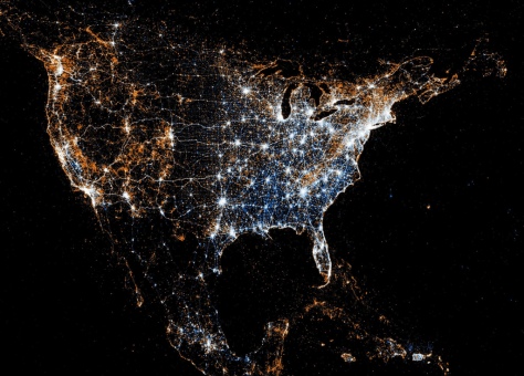
Not that GPS or other electronic maps aren’t awesome in their own ways. Which brings me to the maps in this essay. Several months ago I came across an article in the London Telegraph that contained a link to these Twitter and Flickr maps. Eric Fischer created these unique maps from Twitter and Flickr metadata. Twitter is of course the ubiquitous microblogging website, and Flickr is the premier photo sharing application/website in the world.
Mr. Fischer was able to collect where people geotagged their tweets and uploaded Flickr photos over a period of time in 2011. The tweets are in blue and the Flickr photos are red (overlapping areas appear white). Presuming his sample size was large enough, the maps are probably accurate today. They certainly would appear to correlate with my own idea of where people would be more likely to take geotagged photographs.
The white areas are the most populous areas, and probably where there is more economic activity. So if you are interested in living in areas of high levels of microblogging (and most likely, more economic activity), the white areas on the maps would be the place for you.
If, on the other hand, you are more interested in the most photographed areas where there is less human activity, the red areas would be of interest. In the map below, I have noted some of the significant national parks, recreation areas, and wilderness areas in the United States. These areas correlate closely with high levels of Flickr geotagged activity.
For example, the Rockies generally but Glacier, Yellowstone and the Grand Canyon national parks specifically are among the “hottest” geotagged areas of the country. Other out-of-the-way places, like the Boundary Waters Canoe Area, also stand out. (You really have to click on this photo to see the enlargement and appreciate the Flickr data.)

A closer look at Abingdon Outdoors country shows how our region is practically an island of red along the East Coast. The red spine of the Blue Ridge is clearly visible in the enlargement below, and in the Southeast, the mountainous area of Southwest Virginia, Western North Carolina, and Great Smoky Mountain National Park are the most photographed areas south of New England.
Our region is also unusual in that we are a “red zone” surrounded by white–a relatively less populated, highly photographed area surrounded on all sides by the major population centers of the Mid-Atlantic and Southeast (Washington, Richmond, Charlotte, Atlanta).
Human activity can be very telling about where it is beautiful. In these maps, the red shows what are likely the most photographed, less populated areas of our country. On the United States map above, our region looks similar to the Cascades area of Washington and Oregon, and the Sierra Nevada region to the east of San Francisco.
Lots of people apparently agree that Abingdon Outdoors country is pretty country indeed.

