Have you ever been to a brush burnin’ and rat-stompin’ party? Have you ever even heard of such a thing?
Let me introduce you to an Appalachian mountain tradition: Spring and fall land clearing and cleaning, gathering the debris into a huge pile over a period of weeks or months, and then torching the whole thing one evening. Some folks do this in conjunction with a neighborly get together—thus the party.
One person tends the fire while others enjoy dinner at a biannual brush burnin' party in Rural Retreat, Virginia
The allure of fire has attracted men and women for ages. In modern times, those who spend time in the outdoors know the enjoyment of a campfire in the woods or a bonfire on the beach. Most everyone enjoys a crackling fire in a fireplace. I always get nostalgic about my own youth when around a fire: Sharing a spot in front of the fireplace at my parents’ home with my brother when we came back inside after playing in the winter weather; drinking hot chocolate in front of a roaring fireplace at a lodge or cabin when our family vacationed during colder times of the year; or the old-fashioned campfires we had when car camping across the Midwest. Generations of Americans have enjoyed the huge fireplaces of the grand lodges in our national parks in the West or in famous hotels like the Grove Park Inn in the East.
Sitting around a fire makes us feel warm, relaxed and mellows our mood. We are softened and reminiscent when we stare into the fire, thinking about our lives and talking with friends and family. The so-called “fireside chat” is the informal discussion about serious issues in a relaxed manner, made famous by FDR’s radio addresses in the 1940s. During an evening meal, the simple lighting of a candle can transform the environment and make it warmer and romantic. There is something about socializing in front of the fire to which people are drawn.
In this day and age, there has been a renaissance of the outdoor fire, usually now burned in a fire pit, fire kettle or chiminaya in the backyard of someone’s house. Some could argue that the modern versions of the campfire have become too sanitized: Newer backyards have elaborately constructed fire pits with built-in seating such that they are virtual living rooms outside. Some patios even have fireplaces with chimneys, replete with outdoor kitchens and all other manner of niceties. Many don’t even use real wood. You can just push a button or use a remote control to start the ignition and crank up a gas fire that is supposed to mimic the real thing.
While such controlled and comfortable environments may be desired, there is something to be said for the old-fashioned campfire, just a bunch of brush and twigs on the ground inside of small, hand-arranged stone ring, with flickering coals, true ashes, and the smell of wood smoke. The primitive simplicity of it is what makes it aesthetically as enjoyable as the most expensive, fancy backyard patio.
This is the beauty of brush burning: It’s nothing more than a campfire on steroids. It’s the real deal, and it’s huger than huge.
This month we went to my wife’s parents’ brush burnin’ party. Built with their neighbors, the accumulated brush pile reaches over ten feet in height and about 20 feet in width before it is burned. When torched, the flames lick up high and the amount of heat thrown off is incredible. It’s a sight to see. As the flames grow, the lawn chairs are pulled back and the people retreat to a safe distance. The fire is watched as its flames reach their zenith and then shrink back to a manageable size. Embers form beneath the fire, and the coals are red hot.
The folks all bring their chairs in closer, and the meal begins. Long tables are set up, and prepared food—good country food and fixings—are all laid out. Everyone has brought something: casseroles, beans, cole slaw, chips, dips, buns, etc. (and of course, several desserts like pies and red velvet cake).
Hot dogs are roasted just like they are over a campfire. The main difference here is the device used to roast the wieners. Two-pronged large forks that hold the wieners are attached to poles between 8 and 15 feet in length so that the hot dogs can be thrust into the fire without the holder of the roasting device getting burned. These contraptions are lined up against a nearby tree, ready for battle like knights’ jousting poles in a medieval stadium. Folks roast the wieners while one person minds the fire, making sure the embers stay within the designated area and redistributing the burning material to maintain the brush pile’s heat. As the hot dogs come off the fire, people eat, socialize, and enjoy the flickering flames.
Our brush burnin’ parties these days are just family affairs, but I have attended some in Southwest Virginia that are much larger and are major gatherings for people from all over the county where they’re held. These larger parties are a great time. In some rural communities lots of local “movers and shakers” from the area come out, and county and community business is discussed. It’s a social phenomenon that many people don’t realize occurs. If you are fortunate to get invited to a good old-fashioned brush burnin’ party, you definitely should attend and personally experience this regional outdoor activity.
If you want to start your own brush burnin’ party, remember there are rules in most areas regarding burning. Most of the radio and television news programs broadcast the ubiquitous burning regulations that the state forestry departments announce every spring and occasionally at other times of the year. In Virginia, for example, there is a burn ban in the spring until after 4 pm. There is also a requirement that burning is done carefully, i.e., in a big pile with a cleared area around it. Legally stated,
It shall be unlawful for any owner or lessee of land to set fire to, or to procure another to set fire to, any woods, brush, logs, leaves, grass, debris, or other inflammable material upon such land unless he previously has taken all reasonable care and precaution, by having cut and piled the same or carefully cleared around the same, to prevent the spread of such fire to lands other than those owned or leased by him.
Va. Code § 10.1-1142. Of course, if there is an outright burn ban due to dry conditions, don’t burn anything outside.
Oh yes, and what about the “rat stompin’” part of the party? Supposedly, when the brush pile starts burning, all the rats and other vermin come scrambling out from it. The idea is that you should stomp them as they come out. I have never actually seen vermin come scrambling out, and I certainly have never seen anyone actually successfully stomp on them as they did so.
I will keep looking out for them, though, as I plan to attend many more of these parties in the future. And next time you are driving on a country road or down the interstate and see a bunch of people all hanging out around a big brush fire, you’ll know what they’re doing.
On Sunday, May 22, 2011, a set of late evening thunderstorms came through Abingdon. They left in their wake an unusual reddish hue in the sky, more of an Alpenglow than we ordinarily have in this region (especially for this time of the year). From our house you could see the sky change from dark grey, to burgundy, to red, eventually to a reddish orange. My son Karl and I hopped in the car and hastily drove to some vista points to capture the post-storm sunset, as there were only about five minutes left in the evening to capture the skylight.
Taken from a ridge on the outskirts of Abingdon, this photo overlooks the ragged ridgeline of Clinch Mountain southwest of town. Mist and steam created from the fast moving storm rises from the valley. Click to enlarge.
Landscape photography is something I have always enjoyed and is an interest my son and I have shared for the last year or so. This winter he received a camera which he has been using on our trips outside. In addition, we have become fans of From the Edge, a photography show on The Weather Channel with landscape photographer Peter Lik. In From the Edge, Lik travels to beautiful areas of the United States, primarily our National Parks, and demonstrates photographic techniques. The show at times is a bit over the top, and Lik may exaggerate somewhat how dangerous some of the situations are, but the man is exuberant, the show is entertaining, and the photography and cinematography are gorgeous.
This photo is looking west. Remnants of storm clouds hover and reflect the evening sunlight. Click to enlarge.
Dark purple storm clouds above Clinch Mountain. Click to enlarge. The snaggle-toothed ridgeline of Clinch Mountain that divides Washington and Scott counties is visible in the enlargement.
On this evening Karl and I were able to have our own “Peter Lik” moment inside of town limits as we raced to the west side of Abingdon to get these shots before the light changed. As the photos show, to the west the sky was a fiery red with heavier cloud cover framing a shrouded sunset.
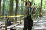
Young photographer adjusts camera on tripod to get the "perfect shot."
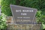
Only 45 miles from Abingdon, Bays Mountain Park and Planetarium in Kingsport, Tennessee is one of the nicest large parks in the region. It is right off of Interstate 26, Exit 3, Meadowview Parkway. The entrance to the park is just a few miles to the south of the exit.
With 3,550 acres and an extensive network of 37 miles of trails, it offers a good place to do some trail running or mountain biking in an enclosed, very pretty natural park. The trails are a mix of old fire roads and single track. There are several good annual trail running races within the park, most notably the Bays Mountain 15 Mile Trail Race, which is in September and starts from the nature center area, and the Laurel Run Ascent, which is in April and starts in Laurel Run Park (accessed from Church Hill, Tennessee). I did the Bays Mountain 15 miler several years ago and can attest to it being one of the nicer trail races in the region.
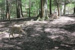
Bays Mountain Park has nature programs and dedicated habitat areas—essentially large pens—for bobcat, wolves, river otters, turtles, and raptors. This area of Bays Mountain Park is similar to the Western Carolina Nature Center in Asheville, North Carolina. There are not as many exhibits at Bays Mountain as at WCNC; however, the wolf exhibit at Bays Mountain is larger and better.
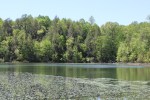
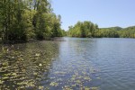
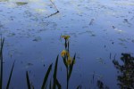
The photo gallery below shows some areas of the park close to the nature center. Click on a photo to see a description of it.
I recently visited Bays Mountain with my son for an elementary school field trip. (This park hosts many school field trips; during our visit there were also school field trips from Scott County, Va. and from Hawkins County, Tenn.). With the school group, we visited the nature center, listened to a lecture on the wolves, and watched a program at the planetarium.
During the wolf lecture, the park official explained how wolves live in packs, their feeding habits and pack behavior, and then demonstrated how the wolves howl. She prompted the wolves to howl with her own human “howl,” which involved cupping her hands to her mouth and then initiating a howling sound and was unlike an ordinary human imitation of a wolf howl. The wolves responded slowly at first, and then all of them seemed to howl together. This lasted several minutes. It was quite loud, actually pretty fascinating to hear, and was the highlight of the trip.
We then proceeded to the planetarium. The planetarium has a modern Carl Zeiss planetarium projector that allows the audience to sit back and look up onto the domed ceiling to watch an accurate representation of the night sky. This was the first time I had seen a planetarium show since I was a child at the Adler Planetarium in Chicago, so it was a treat. The Bays Mountain Park website indicates they also have quality telescopes and allow the public to use them at designated times in the evenings.
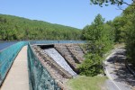
Bays Mountain Park has a 44 acre lake named the Kingsport Reservoir that was apparently originally used as the major source of water for the city of Kingsport. The lake has many inlets, lily pads, and bass and bluegill that were visible from the shore. Overall, this park is a nice asset to the region, one often overlooked as a place for outdoor recreation considering how close it is to Abingdon and Southwest Virginia. It’s definitely worth a day trip.
This interesting aerial photograph, taken during the day on May 5, 2011, shows a thin band of snow on the crest of Iron Mountain in the foreground and two wider bands of snow on Mount Rogers on the left and on Whitetop Mountain on the right. On Wednesday, May 4, 2011, the temperature dropped precipitously across Southwest Virginia in the evening. It rained in Abingdon during the night but as the photo shows it snowed with just a tad of accumulation in the higher elevations.
This week perhaps the worst set of tornadoes in history hit the South. In Washington County, Virginia, where I live, we experienced tornadoes unlike anything in the last 60 years. This tragic event prompted me to recall some of my own personal experiences with extreme weather, and to contemplate the fierce, uncontrollable power of nature from the perspective of those who love the outdoors.
Ignorant of the Danger
On Wednesday, April 27, 2011, I came home for dinner and went back to work at my office in Abingdon, unaware of severity of the impending storm. My wife called me around 8:00 PM, telling me we were in a tornado watch area, and that a neighbor who was coming back from Knoxville had his vehicle pelted with hail while driving up Interstate 81. I told her to call back “when it got closer.”
She called me again at 10:30 PM, and told me in a raised, nervous voice, “Get home. It’s here!”
“What’s here?” I asked.
“Where the #%^* have you been? What do you think? The Tornado!”
I quickly closed down the office and drove home. As I drove home, there was lightning and thunder all around in the sky.
Our family spent the night in our unfinished basement. My wife and I sat in lawn chairs, watching the weather reporters who broke into the regular TV evening programming, while our children lay in sleeping bags on the basement floor. We experienced some anxiety and fear, but I also was curious and strangely fascinated in what was happening. Having grown up in the Midwest, I had experienced tornado watches and had done innumerable tornado “drills” in school, but I did not recall ever previously being in the direct projected path of one.
Actually, there was some disconnect between my view outside of our house and the weathermen’s Doppler radar graphics showing the super cells and tracking them in real-time. I periodically opened our basement door, looked outside, and never did I hear the locomotive engine roar that was associated with tornadoes. There was no incredible wind or horrible hail as was being reported on TV. The closest we got to the action were the sounds of hail pounding the television station studio coming through the TV, thunder in the distance, and the shrill call of Abingdon’s fire engines and ambulances through the night. The worst thing that we physically experienced that night was lack of sleep.
I had to awake and leave early for work Thursday. Our cable TV went out in the early morning, so I did not know the state of affairs until my wife called me and told me the news that a tornado directly hit the small community of Glade Spring. Later that day, my office manager, who lives near Glade Spring (and who thankfully was alright), explained what she saw on her drive to work. “It would make you cry,” she said.
I would later appreciate how bad it was: Glade Spring looked like a war zone, and individuals with whom my family has connections were killed. Numerous students whom my wife teaches at Patrick Henry High School in Emory, Virginia suffered damage to their homes. Virginia Governor Bob McDonnell declared a state of emergency that morning, and as of this writing the roads are still closed in Glade Spring and a curfew is still being imposed there.
Glade Spring is just a few miles from my house in Abingdon. The tornado that hit there would have come right through the middle of Abingdon if it had been on a trajectory just a mile or so to the north. We were fortunate that it did not come through our neighborhood, like the tornado did in 1944.
The storm spawned a series of tornadoes that traveled northeast at high speeds, some as fast as 100 miles per hour. Their glide path essentially paralleled I-81. This may have been what allowed them to maintain themselves. In our region, tornadoes coming from the Tennessee and Ohio valleys usually peter out by the time they come across the Appalachian Mountains. Not this time.
Chastened
On Thursday afternoon I was sent a photo of Virginia Creeper Trail Trestle No. 7. This is one of the longest and most beautiful trestles on the trail. It spans (or spanned) a large dry creek bed on the Smith Farm between Watauga Road and Alvarado, and is the only trestle wholly located in open pastureland, allowing the intricacy of its curved design to be viewed from an approach from either direction on the trail.
The photo was jaw dropping, not only because it showed the trestle completely demolished, but because my son and I had traveled over it and had stopped to take pictures of it barely a month earlier. I could remember the feeling of the cool March breeze across the trestle, the sound of the trestle while running over it (running on the trestles creates a unique, woody, slightly dampened thud with each footstep), and the smell of its aged railroad ties and wooden planks as if we had just completed our workout a few minutes ago. Now I was looking at a photograph of it utterly obliterated.
Photo of Trestle No. 7 taken by Karl Thiessen in late March 2011. This may be the last photo of Trestle No. 7 before it was destroyed.Photo of former Trestle No. 7 taken April 28, 2011
We often forget—or take for granted—the danger of extreme weather and how paltry human frailty is in comparison. It takes an event like the one on Wednesday to humble us and renew our respect for nature’s power.
“So Fast, So Sudden” read the newspaper headline in the print edition of the Bristol-Herald Courier print edition on Friday morning. Seeing the photos of the devastation in Glade Spring, I was chastened to realize how cavalier I had been on Wednesday evening about the power of the storm and the seriousness of the situation.
Measuring Risk
Those drawn to the outdoors know that there is some element of danger in every adventure, and we cannot go outside without accepting some risk. Driving on the highway to and from the trailhead remains the most risky element of most adventures most of the time. Yet the longer it is since we have personally experienced nature’s power, the less conscious and less respectful of it we usually become.
Similarly, those who come away from first-hand encounters with extreme weather completely unscathed also may develop a hubris that leads to being less cautious when the weather may turn poor. We misinterpret our good fortune and consciously or unconsciously convince ourselves that it was not but for the Grace of God that we were spared, but that we have acquired some kind of mastery over nature. Of course, nothing could be further from the truth. It takes something dramatic to shock us into recognition of that which we should know without a reminder.
Sign at the Trailhead to Wilburn Ridge and the Appalachian Trail at Grayson Highlands State Park in Virginia announces "WARNING: Extreme Weather Change - Be prepared for drastic temperature changes"
In the mountains, the weather can change in a heartbeat, and those who go unprepared or ignore the reality of our frailty sometimes suffer serious, even deadly, consequences. The harrowing tale of the storm on Mount Everest in 1996 may be the most held out example of this phenomenon. As reported in Into Thin Air, in 1996 a number of climbing teams, whose leaders were trained and experienced with protocols concerning safety and “turnaround” times lost sight of these rules in their aspiration to get their clients and themselves to the summit of Everest. The teams’ leaders ignored the warning signs and their own protocols when the weather turned bad. As a consequence eight climbers perished and a number of others were permanently injured.
“Summit fever,” as it is known in mountain climbing, manifests whenever people outdoors lose respect for nature’s power, become consumed with themselves and their own personal objectives, and as a result make poor choices that may end in dire consequences. The storm on Everest in 1996 was not predicted and came upon the climbers suddenly. While the climbers could not have avoided all adversity related to the storm, the previous years’ relative safety may have lulled the climbers into apathy or lack of appropriate concern regarding the ever-present danger of extreme weather.
Nature’s Fickleness
I personally experienced an unpredicted and uncanny swift change of weather while on a mountain climbing expedition last year on Mt. Shasta in California. Mt. Shasta, 14,000+ feet above sea level, is the southernmost intact volcano in the Cascade Range (Mt. Lassen, 70 miles away, is technically the southernmost volcano, however Mt. Lassen is not fully intact due its eruption in 1915 that blew most of the top cone off of it).
The main climbing route up Mt. Shasta, known as the Avalanche Gulch route, is easier than the main climbing routes up Mt. Rainer in Washington. We were climbing with several folks who had successfully summited Mt. Rainer the previous year. Therefore, in planning this trip we decided to climb Mt. Shasta via the Hotlum-Bolam Ridge route, a much more difficult, less taken, and semi-technical route with some 45 degree pitches that ascended a ridge between two glaciers on the on the northeast side of the mountain.
We had planned and coordinated the Mt. Shasta climb for months—actually for almost a year. We carefully chose to do the climb during the best “weather window” based upon studies of previous years. We chose the last week of June/first week of July, based upon the fact that the snowpack would still be good but the weather and chances of storms would be minimal.
The weather forecasted for the climb was perfect. No rain or snow was predicted. The first day of the climb, we had great conditions, a blue sky and warm temperatures. At base camp at 10,000’, we were ready for the final ascent the next day and were awoken by the guides at 2 am. We got ready quickly and started climbing in the dark for the summit push.
View of the Hotlum-Bolam Route on Mt. Shasta taken June 28, 2010, the first day of the climb. There was not a cloud in the sky, and perfect climbing conditions were forecasted.
We were surprised, however, that it was colder than expected—mainly because of the wind chill. None of us remembered seeing anything on the weather reports before the trip about the wind chill. With the wind chill, the temperatures were below freezing. At one rest stop at about 12,000’, I began to shiver uncontrollably. The guide told me to take some ibuprofen, that the altitude may have caused some swelling in my blood vessels that could be affecting my circulation. As we continued to climb, I would warm up while moving, but the wind chill was making our rest stops, which were a necessity at the altitude, difficult because we were cooling down so fast every time our movement stopped. And with each stop higher on the mountain, the wind’s intensity increased and made it still yet colder.
The route required us to climb more or less straight up the northeast side of the mountain until we were almost at the summit. About 200 yards from the summit our route required us to traverse around the north side of the mountain to the western side, where we would walk across a flat section near the top about the size of a football field and then climb just a few feet to the true summit on the southwestern peak.
As we began the traverse, the wind velocity continued to increase with each step. The wind was blowing 40+ miles per hour in our faces. Walking forward with crampons became difficult. With two groups of five climbers roped together, our purchase on the rocks and snow during the traverse was becoming increasingly more treacherous due to the winds. As we continued to travel around the mountain, gusts began literally blowing us backwards. Each of us looked like a news reporter getting blown by hurricane force winds on the beach. Except unlike at the beach, if one of our groups fell, the plunge was 1500 vertical feet down a steep ice and rock covered slope.
Climbing towards the summit around the north peak of Mt. Shasta. Ferocious wind velocities began as we rounded the bend on the left of this photo.
As we came around towards the west side, several of us slipped and almost fell. The guides huddled us together, each of us lying down so that we would not get blown away. We conferenced about whether it was safe to continue. We had to scrunch our heads close together to hear each other in raised voices over the howling of the winds. Several of the members of the group pleaded to continue. The guides explained we were still in a protected position on the lee side of the mountain. They told us that when we went around the mountain—only about another 100 feet or so—the wind speeds would pick up to 70+ miles per hour based upon how they were ripping around the mountain to where were currently located. We were told the summit was a no-go: “When you go around the corner, it will be like sticking your head straight into a hurricane. We cannot cross the flat area. You will get blown off.”
We could see where we had to go. It was just behind those rocks above us . . . you could almost reach out and touch it . . . it was so close. You could smell it, too—the sulphurous odor coming from the top of the volcano was detectable notwithstanding the ripping winds. After eight bleary-eyed hours of climbing in the wind, after tramping up to base camp with fully loaded packs the previous day, after assembling the whole group in California, after many of us individually traveling across the United States from Virginia, after all the anticipation, planning, and effort . . . it was so damn close. There was a strong temptation just to ignore the safety concerns and continue onward.
We agreed to a compromise: We would try to attain the north summit, only about 100 vertical feet up the mountain. One group would proceed about 40 feet in front of the other. Being in the second group, I followed the first group climb up the final section of the mountain. After about thirty steps, each of which seemed to be in slow motion, I glanced up and saw more spindrift than usual swirl up around the corner of the mountain, exactly where we were headed. An instant later, a huge gust of wind hit us. It blew the group in front of us down. In unison, just as we had been taught, each member of the fallen group self-arrested. (Self-arrest is the alpine technique to drop and plunge your ice axe into the snow to stop, or arrest, a fall down the slope of the mountain). All of the members of the first group were chest down on the snow, but they were not sliding and were secure in their place. The group’s lead man, one of our guides, turned his head and squarely looked back at us. He raised his hand to the front of his neck and very deliberately moved it back and forth in a chopping motion. Although he spoke no words, the message was clear: “We’re done.”
We were less than a hundred vertical feet from the summit, and yet nature had turned us back. That afternoon, back at base camp, we knew we had done the right thing. The conditions had been too dangerous to proceed. The guides suggested we should count the climb as a success, since it was not lack of physical conditioning or human error that caused the summit to elude us. We were practically there. Practically. Sometimes, reflecting back on the trip, it continues to gnaw on me to this day that we were so close yet had to turn around right at the summit. On the other hand, the weather added an epic perspective to the trip and provided an up close glimpse of the physical and psychological conditions world-class mountain climbers experience when confronted with extreme weather.
While the Southern Appalachians and the Blue Ridge may not have the altitude of the higher mountain ranges, there are similar dangers in our region that are inherent in outdoor activities in relatively remote locations. A good friend and I went on a winter backpacking trip once in the Mount Rogers National Recreation Area, and we almost got stuck in a two foot snowstorm. That snowstorm was totally unpredicted.
Late season snow can hit higher elevations even in the South. We once were caught in a huge snowstorm in the Smoky Mountain National Park and were forced to stay in an overcrowded shelter. When we got back home, we saw that the freak storm had caused an unheard of snow delay during the spring race at the Bristol Motor Speedway. While on both of these occasions we were prepared with equipment and clothing, the weather took us by surprise and changed the scope of the trips.
I am sure there were backpackers and campers in the Cherokee and Jefferson National Forests when the tornadoes came through our region. Some were probably shocked by the change in the weather even if they were on the periphery of the tornadic activity.
Nature’s Mercy
Summer storms can be the most dangerous type of weather in the mountains. Perhaps the scariest weather phenomenon I have experienced was in Rocky Mountain National Park in July 2002. My wife, young son Karl, and I went to Colorado for a vacation. We camped in the national park, and one of the days I went for a day hike with my son in a Kelty child carrier. This is a carrier that has a child seat built into an external aluminum frame that the adult wears like a backpack. My son and I were traveling up one of the lower approaches to the Keyhole Route, the famous hike that climbs Longs Peak, the highest mountain in the park. My idea was to hike up the trail for a few hours, and then head back to the parking lot.
Photo taken a few days before the climb on the Keyhole Route in Rocky Mountain National Park in June 2002
We left the parking lot in the middle afternoon on a beautiful, warm summer day. The sky was cloudless and cobalt blue. After about an hour of hiking, during which we passed other hikers, a single, low-lying cloud became visible as it skirted across the mountains we were approaching. The cloud hugged the mountains, snaking over them and towards us, expanding as it approached. At first it was innocuous but became ominous as it got closer. The sky above us started to turn from blue to grey, even though the sky was blue everywhere else. The dark, grey mass came right at us. We turned around and started back down the trail. I walked as quickly as I could with Karl in the backpack carrier.
Then I could feel the electricity in the air. The hair on my neck literally started to stand on end. My three-year old son, sensing the danger, started to cry uncontrollably. Lightning flashed everywhere, in the heavens and with crystal-clear sharp, white bolts striking the foot of the mountains immediately behind us. The thunder reverberated in the amphitheater of peaks surrounding us, amplifying the already deafening sound. The dark cloud with wispy white tendrils swirled around us, seemingly inescapable, as if we were being drawn into a grey whirlpool above.
I had experienced this kind of weather before in the East and Midwest, but with less intensity. I had also read about what was happening to us. Anyone who has researched hiking out West has read about the quick developing, high altitude summer lightning storms prevalent in the Rockies. I knew I was about to be in the middle of one, and I knew they could be deadly. And I was acutely aware that I had my helpless toddler son strapped on my back in what amounted to a high-tech version of a lightning rod.
Telling Karl everything would be alright in the most soothing voice I could manage in the middle of a full-on lightning storm and saying a silent prayer for both of us, I walked still faster to get below the treeline. Then, just as quickly as it developed, the storm cloud dissipated. “So fast, so sudden,” it was gone. In fact, by the time we made it back to the trailhead, the sun was shining again. Nature had been merciful on this day.
Respect
While I have not had an experience quite as scary as the one in Rocky Mountain National Park with my son, I have been in several situations that are comparable while hiking and running, and I have been caught out on the road cycling numerous times and subject to unpredicted torrential downpours. Indeed, afternoon lightening and thunderstorms are practically de rigueur during the summertime in the Southern Appalachians.
As we have known since time immemorial, as Robert Burns wrote in 1785, nature may cause men’s best laid plans to go awry. Sometimes the effect of nature’s power cannot be avoided—the devastation in Glade Spring is an example of this. From our perspective as outdoorsmen and women, such incidents serve as reminders that we should always respect nature’s power, be humble, and not allow our vanity and hubris to ever lead us to underestimate the dangers when we go outdoors.