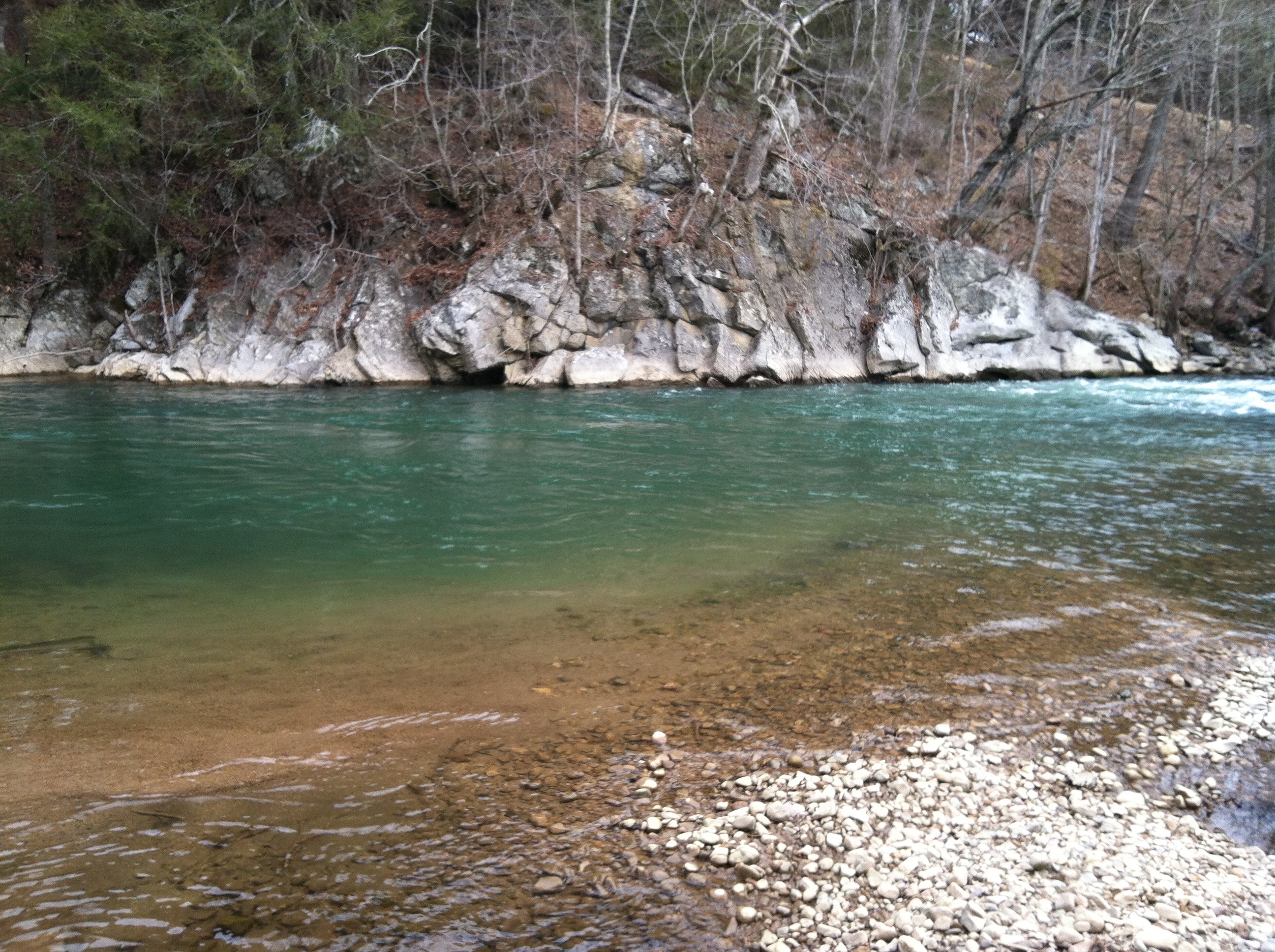
This weekend we went for a walk down the VCT near Alvarado. The melted snow run off from the mountains colored the South Fork of the Holston, making the deeper pools bluish green. The water was just a bit high. The section of river from Damascus to Alvarado was likely about the right level for kayaking.
One of many emerald pools on the South Fork of the Holston River, Washington County, Virginia, March 1, 2014
On Saturday, August 22, 2012 our whole family went to Hungry Mother State Park to enjoy a day on the lake and to try out our newest toy—a 2012 Dagger Zydeco 9.0 Kayak.
Kayaking Hungry Mother Lake
Back in April I saw the new edition of the Zydeco at an outdoor store over in Boone, really liked it, and so I ordered one. I purchased it to be used with my 10-year-old, 12′ Perception Antigua Kayak for group trips or for quick “throw the ‘yak on the roof and go” short trips. In mid-June we picked it up, and we have been waiting for a several months to test it out.
So we packed up the Jeep for a picnic, put the two ‘yaks on the roof, and brought along some spinning rods for good measure. It was a beautiful day in the mid-70s with low humidity. The sky was mostly sunny, and the lake was really busy.
Hungry Mother State Park Beach
The beach was open, and my two boys were suddenly more interested in swimming and going off the diving boards than kayaking, so I took the new Zydeco for a solo trip all around the lake.
Circumnavigating the entire lake takes over an hour, as it’s about a 100 acre lake and there are approximately 3 or so miles of shoreline. I’ve kayaked from one end to the other and back in under 35 minutes while racing in the Mountain Do Triathlon multiple times, but it had been a while since I had just gotten out and kayaked for fun on a summer day. Consciously trying to stay close to the shore, in order to truly go around the whole lake, it took about 1 hour, 20 minutes of consistent paddling.
View from Near the Dam
As I have written previously, Hungry Mother State Park also has trails that circle the lake, as well those that climb to the top of Molly’s Knob. With all that this park has to offer, it is still probably a bit underutilized except for some of the busier summer weekends. From my own personal use perspective, this suits me (and, I suspect, most of the other park patrons who live around here) just fine.
Clouds reflecting on the lake create shadows on Walker Mountain in the background
So, how did the Zydeco handle? Overall, pretty well. It’s very manageable at 36.5 pounds (a lot easier to get on the roof than the 49 pound Perception) and very easy to turn. The lighter weight suits it well for smaller folks, which is one of the main reasons I got it (for my boys and wife).
Hungry Mother State Park Kayaking Panorama
The shorter length does make the Zydeco track a bit less well than the Antigua (meaning it doesn’t hold a straight line without correction as well. Better tracking generally allows for more powerful paddling).
Boys Kayaking–Zydeco 9.0 on the left, Antigua 11.9 on the right
Both the Antigua and the Zydeco are “Adventure Recreation” kayaks, meaning they’re designed for light touring or class I or II+ whitewater, not for sea kayaking or hardcore whitewater rafting.
Zydeco 9.0 in Action
The Zydeco fits the bill for what we’ll need for the next several years when we go on family, mild whitewater, and fishing trips in the region. I think the two kayaks will pair up well for our future adventures.
This is the second article in my short series on the New River. This summer we canoed and fished several sections of the New River, first exploring the upper section in North Carolina, then the middle section that flows through Virginia, and finally the section that flows through the New River Valley and into West Virginia. In the first article, I reviewed the section of the New River below the confluence of the North and South forks of the river. This article is about our second trip where we fished and camped at Foster Falls in August 2011.
The Cliff at Foster FallsShallow Water and Rocks Visible at the Falls
The New River leaves Ashe County and Alleghany County in North Carolina and crosses the state line and flows into Virginia at Mouth of Wilson in Grayson County. It then briefly crosses back into North Carolina and then back into Virginia again near Fries, Virginia. The river then flows through the eastern part of Grayson County and into Wythe County. As the river flows through the eastern part of the Appalachian Mountains in these counties it gains considerable volume and size as various tributaries add water to its flow.
Shortly after flowing under I-77, the New River has a series of step-like waterfalls that spand the entire width of the river and are collectively classified as a class 3 whitewater. This area is known as Foster Falls and is the site of Virginia’s New River Trail State Park.
Great Biking
The New River Trail State Park is a unique Virginia park: A 57-mile linear state park with various facilities located at different segments of the trail. The main facilities are located at Foster Falls, where there is a small “walk in” campground, river access for fishing and a boat ramp, picnic areas, horse stables, and a canoe livery with a small shop.
The New River Trail itself is a converted railroad bed. The trail is a packed dirt/ash trail that is excellent for mountain bikes or cross bikes. The trail has several trestles that cross the river and also has a tunnel or two that cyclists travel through. The trail is a level grade, with only a few minor hills, and generally follows the New River between Fries and Pulaski. Foster Falls is the approximate half-way mark on the trail, and makes a good base camp to cycle in either direction on the trail.
This trail is scenic with minimal traffic and road crossings. After the Virginia Creeper Trail, it’s probably the nicest off-road cycling trail in Southwest Virginia.
Smallmouth Country
Low water allowed for great wet wading and fishing
The New River is renowned as one of the premier smallmouth fisheries in Virginia. Actually, it’s one of the premier smallmouth fisheries in the United States. The river also has large populations of musky and other game fish. The New holds Virginia’s state records for largest smallmouth bass (8 pounds, 1 ounce) and largest musky (45 pounds, 8 ounces.)
Isaac nabs a nice 14 inch smallie
There are several areas to fish right at Foster Falls. I believe the key to fishing any large river, but especially the New, is to spread your casts methodically over fairly large areas of water to reach the most fish as possible and then move on. Unless you are bait fishing and patient, covering a section of water and then moving on to another section is the best way to cover this river.
We therefore first bank fished the river, then waded parts of the river where it was shallow and fished across a large island adjacent to the campground. I fly fished with streamers and caught about 10 smallies with a size 8 olive wolly bugger. My sons Karl and Isaac used Mepps and Blue Fox spinners on light and ultra light spinning tackle. They caught about a dozen fish between them.
Great Camping
Foster Falls campsite. The New River is seen right behind the campsite.
There are only 12 campsites at Foster Falls. Thus, although it is a group camping area, the sites are dispersed and there is a wonderful absence of what I sometimes call the “Camp Jellystone Effect”−hundreds of sites jammed together creating a permanently smoky area that from a distance resembles a foreign refugee encampment as sometimes seen on the evening news.
The Falls Near the Camprground
Also, because these are “walk in” sites, there are no RVs or trailers. You have to park in a designated parking area and carry your camp gear between 100-200 feet to the designated campsites. This is not that difficult, and, much to my surprise, the state park provides little wagons for campers to transport their gear from the car to the campsites.
"Walk In" Campsites
Most of the campsites are either right on the river, or very close to the river (with river views). The camground also provides a sheltered area with dry wood for the campers. You simply have to pay a daily fee, and then you may transfer the firewood to your site for your own use. This was convenient and a reasonable way to provide firewood (if you run out, you simply go back to the covered area and get a few more logs).
Kayaking and Canoeing
Although we didn’t do any boating, there is the possibility of boating both up river and down river from Foster Falls. Running the falls looked a bit sketchy. When we were there in August, there did not appear to be sufficient water to successfully navigate the falls. We saw one kayaker dragging his kayak down the river; it didn’t look fun.
I have kayaked the section of the river above the falls previously (my brother-in-law once took me down this section when a summer lightning and thunderstorm developed in which I feared for my life−getting caught on the water under these conditions can be scary). During higher flows, this can be a moderately challenging kayak with lots of riffles and fast water, but there are not too many obstacles. Downriver from the falls the river slows considerably as it approaches and eventually forms the upper part of Claytor Lake.
Kayaker Down River from Foster Falls
We will definitely return to Foster Falls, probably with a bike focus on our next trip. However, I will also have to bring more marshmellows, Hersheys chocolate, and graham crackers next time. Because this time, these ingredients seemed to mysteriously disappear each night.
This is the first of a short series of articles that will examine the New River, the largest river which flows through Southwest Virginia, and the source of great outdoor opportunities in the region including paddling and fishing.
Canoeing the New River in the North Carolina "High Country" - Click to Enlarge
Purportedly the second oldest river in the world (only the Nile in Africa is older), the New River predates the Appalachian Mountains (themselves some of the oldest mountain ranges in the world). Geologists explain that this river existed before the tectonic shift that caused the uplift of the Appalachia range. The river more or less continued its present-day path during the tectonic shift, cutting through the mountains as they were created.
The New begins high in the mountains of northwestern North Carolina. The New actually starts as two rivers, the North Fork and South Fork of the New. These two forks join in Ashe County before flowing north and west through Virginia into West Virginia. The mighty New ends when it confluences with the Gauley River to form the Kanawah River, which flows into the Ohio River at the West Virginia/Ohio state line.
In the 2001 bestseller Far Appalachia, author and radio host Noah Adams travelled the length of the New River from North Carolina to West Virginia, recounting the scenery, his interactions with local residents along the way, and his autobiographical musings about his own family’s heritage in the region. In the book, Adams notes that there are two views as to the source point, or the true beginning, of the New. On the South Fork, it is somewhere near Blowing Rock; on the North Fork, it is somewhere on the upper part of Snake Mountain, one of the highest peaks in northwestern North Carolina. (As an aside, Blood, Sweat and Gears, the well-known challenge century road bike race that starts and ends in Valle Crucis, NC every June, traverses the high road over Snake Mountain. I can attest it is very difficult climb on a road bike.)
My son Karl and I did our own “section” paddle trips and travels to different parts of the New River Blueway, or paddle trail, over the course of this summer. For non-hiking readers, a “section” hike is the partial completion of a long trail, like the Appalachian Trail, in “sections”. Most hikers on the AT, for example, are section hikers, not thru hikers. We applied this concept to the New River, taking on several distinct sections of the river to observe and experience the river along its course. This article is the trip report about the first section. In June we travelled from Abingdon to Ashe and Allegheny County to paddle a 13-mile stretch of the South Fork of the New (above the confluence). This section of the New is part of the New River Paddle Trail in North Carolina. An excellent map of the New River Paddle Trail in North Carolina is here.
possess outstandingly remarkable scenic, recreational, geologic, fish and wildlife, historic, cultural or other similar values, [and] shall be preserved in free-flowing condition, and that they and their immediate environments shall be protected for the benefit and enjoyment of present and future generations.
This section of the river is also part of the North Carolina New River State Park (there is also a New River State Park in Virginia, but that is for the next article). We elected to paddle the section from Wagoner Road to Route 221. The trip is about a five or six-hour paddle, not including stops. Here was our route:
Wagoner Road to Route 221
In North Carolina the New River is still a moderately sized river. Both the North Fork and the South Fork are navigable. There are apparently some trout in the upper reaches of the New River, most notably high on the North Fork section. However, where we were paddling the river was already somewhat warm (compared to trout waters). The section of the New from the confluence to the Virginia state line is supposed to be a fairly good smallmouth fishery. We were above that section. We fished the 13-mile stretch of the South Fork intermittently with light spinning tackle, and did not catch anything.
Yes, That's Really Rhododendron on the River! - Click to Enlarge
The flora up in the North Carolina High Country is a bit different from down in the New River Valley in Virginia. For example, there were rhododendron on the banks of the river and stands of pine trees mixed in with the hardwoods.
Make no mistake, although moderately sized, this is still a powerful river. There are numerous boulders and riffles that I imagine cause current changes to a much greater extent when the river is at a higher cubic feet per second (CFU). We ran the river in low water, however it is probably quite a different river during the springtime. On this section of the New, where it is designated a National Scenic and Wild River, there are relatively few homes or other signs of development. You go through whole sections of river where the trees come right down to the water, and there are no homes visible up river or down river.
Geese and Goslings
On this paddling trip, we saw geese, beaver or otter, osprey, and ducks. There were also hunting blinds set up in some of the open fields along the river. The water along the 13-mile stretch we paddled was mostly flat or moderate Class I rapids. There were a few submerged rock shelves over which we had to paddle, and we almost bottomed out in a place or two.
Overall, this is a nice paddle trip. It may be a bit long for some folks. There are shorter alternatives along this route, and both up river and down river from the section that we completed. The New River State Park has several access points.
One thing we did not do, that should be done if you are in the area, is have breakfast or lunch at Shatley Springs Inn, an old inn and restaurant that is a true old-timey place renowned for its family style dining with delicious North Carolina country food.
Breakfast at Shatley Springs and/or a canoe trip down the New would be an excellent day trip down from a camping trip in the Mount Rogers National Recreational Area in Virginia. We have in fact done this in the past.
Cumulus Clouds Over the New River
Directions
It takes about 1 1/2 hours to drive from Abingdon to the Route 221 Bridge crossing (where the New River State Park is located, and where we rented our canoe). From Abingdon, drive to Damascus, then up Route 58 past the Beartree Lake area. Up on the mountain, Route 58 makes a sharp right-hand turn. You can continue on Route 58 through Whitetop, or instead stay straight on Route 603, aka Konnarock Road. Either one will eventually take you to Route 16/Route 58 south. I prefer going via Route 603 over to Route 16, as it is a straighter road.
At Route 16/58 head south to Mouth of Wilson. Drive through Mouth of Wilson. Here Route 16/58 split. To get to the New River State Park at the Route 221, bear left and stay on Route 58. After about 1 mile there is a junction with Route 93. Turn right on Route 93. This turns into Route 113 at the NC state line.
Drive on Route 113 for about 8 miles, until it junctions with Route 221. (At this intersection is a BBQ restaurant called Motleys.)
Make a right on Route 221. Route 221 is a very twisty road, taking you through the small community of Scottsville, NC (just a few homes and churches) and after about 5 miles on Route 221 you will see the signs for the New River State Park. A nother mile or so and you will cross the New River. Immediately on the right there is an old General Store with inadequate parking right on Route 221. Behind this store is New River Outfitters.
Note: There are plenty of other outfitters in the area. National Geographic makes an excellent map of the entire New River watershed, it is Map 773, New River Blueway, and it contains names of most of the outfitters in NC, VA, and WV with their locations identified clearly on the map.
Note: This area of North Carolina is very rural, and the roads are very twisty. Getting around is not intuitive until you know the roads. Carry a good map, use a GPS, etc. In addition, this makes getting to and from the canoe/kayak drop off points difficult. This is another reason using an outfitter in this area is good idea.
This weekend two good friends, my wife, and I drove over to Boone, North Carolina for the evening to attend the local screening of the Banff Mountain Film Festival at the Farthing Auditorium at Appalachian State University. The Banff Mountain Film Festival is the largest and oldest film festival for celebrating mountain sports and culture. The festival takes place in Banff, Alberta, and then a shorter version travels around North America (and the world) for screenings of the best films. The Boone screening, a two night affair, is supposed to be one of the largest outside of the actual festival in Banff.
Our road trip was about an hour and ten minutes via Route 91 through Mountain City, Tennessee and up Route 421. As we went through Trade, Tennessee, we were treated to a setting sun shining directly on snow-capped mountains on the North Carolina side of the state line. The upper half of the mountains had a nice dusting of fresh snow that looked like someone had dumped powder sugar on them. Apparently it had been snowing all day in the higher elevations, setting the mood nicely.
Arriving at Farthing Auditorium, the crowds were raucous, and there was a lot of energy anticipating the screening. We watched five films. WildWater, Eastern Rises, and The Swiss Machine were the most memorable. WildWater is about the spiritual aspects of paddling in wild places and the devotion of those who paddle. The film contained incredible footage, including creek boating in Colorado, rafting in the Grand Canyon, and the massive rapids of the North Fork of the Payette River in Idaho during high water.
Eastern Rises seemed to be the best liked film of the night. It documented a bunch of guys who took an incredible fly fishing trip to Kamchatka, Russia. Kamchatka is one of the most remote areas of the world: A vast, basically unpopulated peninsula across the Bearing Sea from Alaska and to the north of Japan and China. In the film these guys fished super remote rivers and streams, many without names. The trout were huge, and they were rising to go after gigantic custom-tied flies. The guys’ reverence for trout fishing and the pristine waters they fished came through, and their irreverence towards one another was hilarious. This is one entertaining movie regardless of whether you are personally into fly fishing.
The Swiss Machine was an adventure biography of Ueli Steck, an alpinist who is a speed climber. The film shows Steck climbing in the Himalaya, Yosemite, and in the Alps. The film leads up to his speed ascent of the north face of the Eiger. Viewing the steepness of the Eiger face on the big screen almost made me queasy. The filming shows how dangerous speed climbing can be. Yet the film is quite inspirational. Steck’s athleticism and determination are well conveyed for such a shorter film. The cinematography in the final scene is superb.
Coming back from the screening, appropriately enough it began to thunder snow on the drive home. This is in April in Virginia, mind you. There are additional screenings of the Banff Film Festival in other places this year. This was the first year I was able to attend the annual festival; if you have a chance to see it sometime, I highly recommend it. It’s inspirational and definitely makes you want to go get into the outdoors in the mountains.