Tag Archives: Smoky Mountains

Happy 75th Birthday, Appalachian Trail

This month marks the 75th anniversary of the completion of the Appalachian National Scenic Trail.  (To be precise, it was finished on August 14, 1937.)  The trail is 2,180 miles long, has over 250 three-sided “shelters,” and links innumerable other trails through 14 states.

180 Degree View as the A.T. Approaches Thomas Knob Shelter, Mount Rogers, Virginia

For three-quarters of a century people from all over the United States–indeed, from all over the world–have been trekking up and down the Appalachian Trail, or A.T., as most folks in the know refer to it.  In commemoration of this milestone, this weekend I hiked a section of the A.T. between Mount Rogers and Whitetop Mountain.
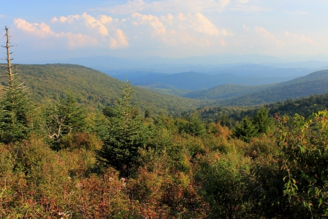
View from A.T. approaching Mount Rogers’ Spur Trail, at 5500′

Founded by a small group of hikers, particularly one forester named Benton Mckaye, who envisioned an East Coast “super trail”, the Appalachian Trail Conference started work on the A.T. in the 1920s.  By 1930 the trail began to take form as small groups of volunteers worked up and down the mountains of the East.  According to the Appalachian Trail Conservancy, this was not a government project but the accomplishment of private, local clubs who mapped and routed sections of the trail, negotiated with private landowners and governmental agencies, and did the physical labor to build it in their respective areas.

To this day, although the A.T. is now owned by the governnment, the Appalachian Trail Conservancy and the many volunteer organizations are critical to the maintenance of the trail. 

View from A.T. into North Carolina it approaches the Mount Rogers’ summit

After World War II, volunteers renewed development of the A.T.  In 1948, Earl V. Shaffer, an Army veteran who served in the Pacific Theater, completed the first “thru hike,” or continuous hike of the entire A.T., reportedly in order to “walk off” the stress of the war.  In the years since, the A.T. has become a cultural phenomenon in addition to being an outdoor experience.  Every year hundreds of individuals from all walks of life attempt to thru hike or section hike part of the A.T., seeking solace, self-exploration, or temporary escape from urbanity on the trail.

Balds on Mount Rogers – Whitetop Mountain Looms to the South

In 1968, the United States Congress passed the National Trails System Act, and the A.T. was the first completed national trail designated a National Scenic Trail.  This added the A.T. to the system of national parks.  The A.T. links two national parks (the Great Smoky Mountain National Park and Shenandoah National Park), and includes Abingdon Outdoors’ own Mount Rogers National Recreation Area.  While the A.T. has always crossed the MRNA, the trail used to traverse the Iron Mountains to the north of Mount Rogers and Whitetop Mountain.  It was re-routed over Mount Rogers and Whitetop due to scenic beauty of these highest mountains in Virginia.  The old shelters on Iron Mountain are still maintained as part of the Iron Mountain Trail.

Cabin Creek Bald Panorama in the Mount Rogers National Recreation Area

Most folks—like myself—have no intention (at least no immediate intention) of hiking the entire length of the A.T.  Most folks hike part of the trail in a day, or at most over the course of a weekend or for a week or two.  The trail is also frequently utilized by the Boy Scouts and by church and civic groups for hiking and camping trips.
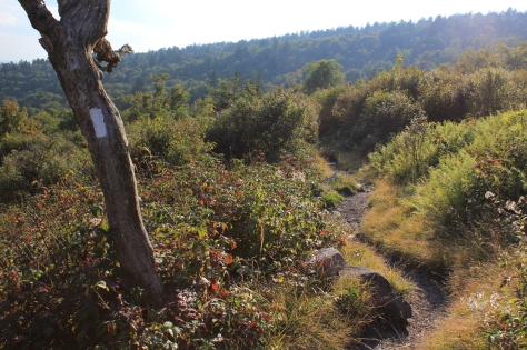
Southbound on the A.T. on Mount Rogers

The trail is designed not to be easy:  It randomly meanders and seldom takes the easiest path from point “A” to point “B”.  At points it certainly appears as if the A.T.’s designers purposely placed obstacles such as rocks and roots in the way.  This keeps the trail challenging.

Root Strewn Section of the A.T.

The A.T. is different things for different people:  A place for solitude and meditation; a place for a communal outdoor experience; a training ground for other pursuits; a naturalist’s place to study flora and fauna.  Perhaps Benton MacKaye best answered the question, “What’s the ultimate purpose of the Appalachian Trail?” 

He said, “To walk.  To see.  And to see what you see.”

Happy Birthday, A.T.  . . . See you on the trail.

View from the Appalachian Trail on Mount Rogers

Tour de Rocky Top: A Twisty, Thirst-Quenching Metric Century

The Tour de Rocky Top is a metric century ride in Knoxville, Tennessee organized by Race Day Events, a private race organization.  This ride is unique in this region in that it starts and finishes at a large pub, Barleys Tap Room.

I did this metric century on Saturday, July 2, 2011.  The ride went through downtown, across the Tennessee River, and out into the country to the south and east of Knoxville towards the Smoky Mountains.  The ride never got into the mountains, but had many rollers, totaling about 3,000′ in total elevation in climbing (and descending) in the 62 mile course.   There were three well-stocked aid stations on the ride.

The staging area for this ride was excellent.  It began right next to Barleys Tap Room.  Adjacent to the tap room is a six lane off-ramp/overpass.  The City of Knoxville has turned the area under the overpass into a very large parking lot.  This was a perfect area to park and leave vehicles in the shade while cycling.  The ride started cool but became quite hot.  Who would have thought riding in Knoxville in July under a noon sun could get hot?  On the negative side, there was no place to shower at the end of the ride.  You pretty much had to just change into street clothes next to your car or go into Barleys and use the restroom to do so.

This is definitely more of true “tour” than a race.  While there may have been a lead group pushing the pace at the front (I don’t know if there was or not since I was at the back side of the starting line), there were about 45 turns on the course.  Every time you got up to speed or began to proceed in a good rhythm it seemed like there was a turn.  And many of these turns were not your gradual “bear to the right or left” turns, but true 45 degree turns on small country roads, several at stop signs.  So this ride was not conducive to a personal best time record, but it was nonetheless a pleasant tour of the countryside around Knoxville.  The race organizers did a good job of getting the riders out of and back into the downtown area on roads with relatively slight traffic, which was impressive.

I finished the ride in approximately 4 hours.  Actual riding time was about 3 hours, 40 minutes.  The average speed on my odometer was 16.2 mph.

The ride ended on a great note.  The ride ended at Barleys Tap Room, a restaurant with excellent pizza in the old town section of Knoxville.    The Barleys in Knoxville is an open, unfinished warehouse with brick interior walls, large rough-hewn beams, and a nice garden patio.  Barleys had two large flat screen TVs showing coverage of the first day of the Tour de France.  Watching part of “the” Tour with several hundred fellow cyclists after doing a century ride was a nice way to start off the Independence Day weekend.

A note on getting to the ride:  The venue is about 1 hour, 50 minutes from Abingdon.  It is a straight shot down I-81.  It makes for an early morning to do the trip in one day.  There are several nice hotels in downtown Knoxville close to the race staging area, and there are lots of restaurants and boutique stores in this area of Knoxville.  Going down the evening before would probably not be a bad idea.