
My son and I spent his birthday on an all-day kayaking trip to Laurel Bed Lake, one of the most remote lakes in Virginia. Laurel Bed Lake is about 330 acres and is located in the center of the Clinch Mountain Wildlife Management Area, Virginia’s second largest such area.

The trip to the Clinch Mountain Wildlife Management Area takes a while to get to from anywhere. From Abingdon, it’s about 35-40 minutes.
Once at the CMWMA, the drive up to the lake takes about another 35-40 minutes, because you have to drive up Clinch Mountain. There is a map of the CMWMA available on the VDGIF website (it is located here).
While the gravel roads are maintained, you should have a four wheel drive vehicle (in fact, the road is often closed in winter). There are several significant switchbacks. The vertical climb from the entrance to the lake is about 1300′, most of it along Big Tumbling Creek, a boulder-strewn creek with numerous waterfalls.
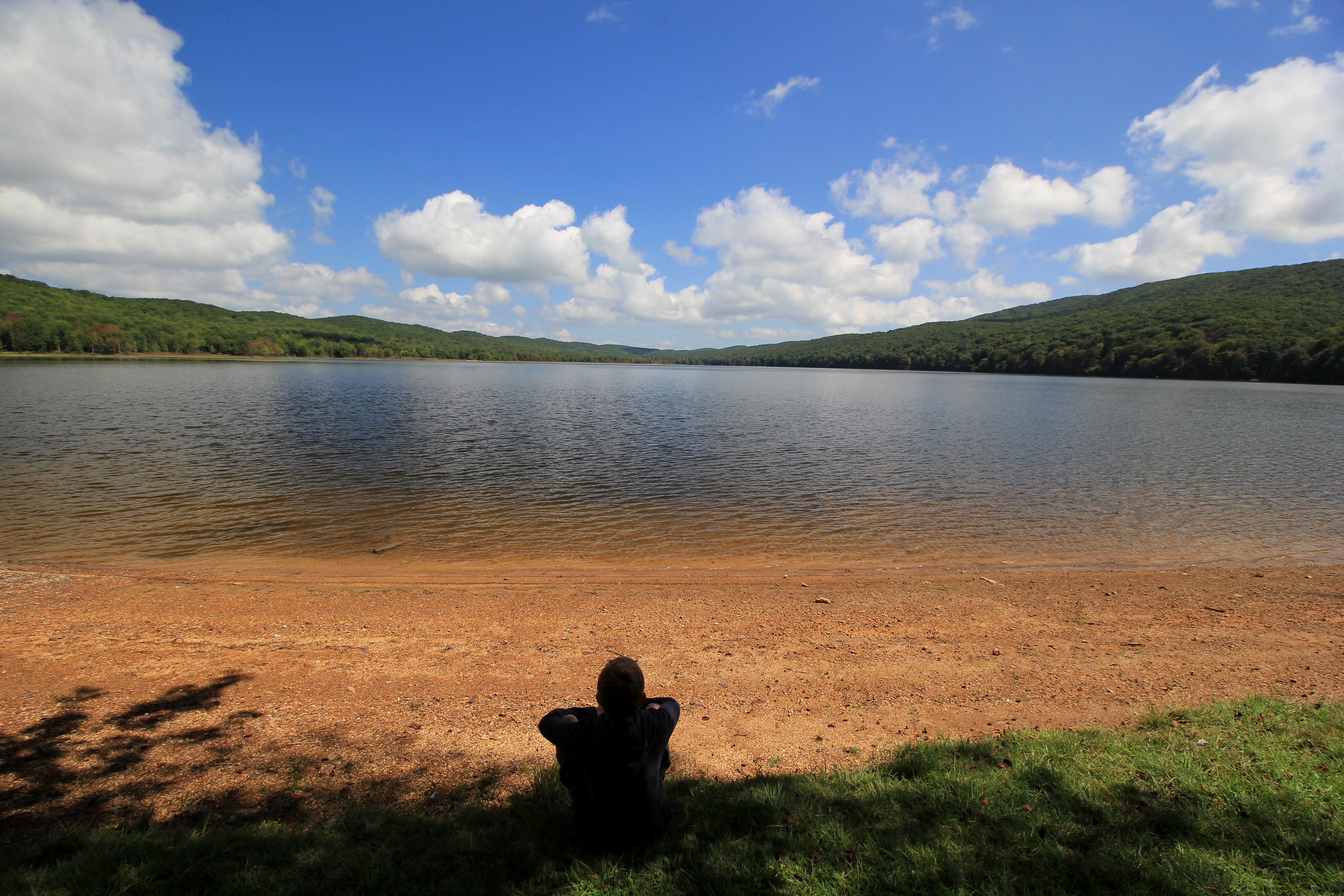
There are smallmouth bass and brook trout in the lake, although we did not have any luck fishing on this day. We did, however, spend about three hours kayaking around the lake: this is a large lake, at least by comparison to the other high mountain lakes in the Southern Appalachians. For example, this lake is much larger than nearby Hidden Valley Lake or Hungry Mother Lake in Virginia, or Julian Price Lake near Blowing Rock, NC.
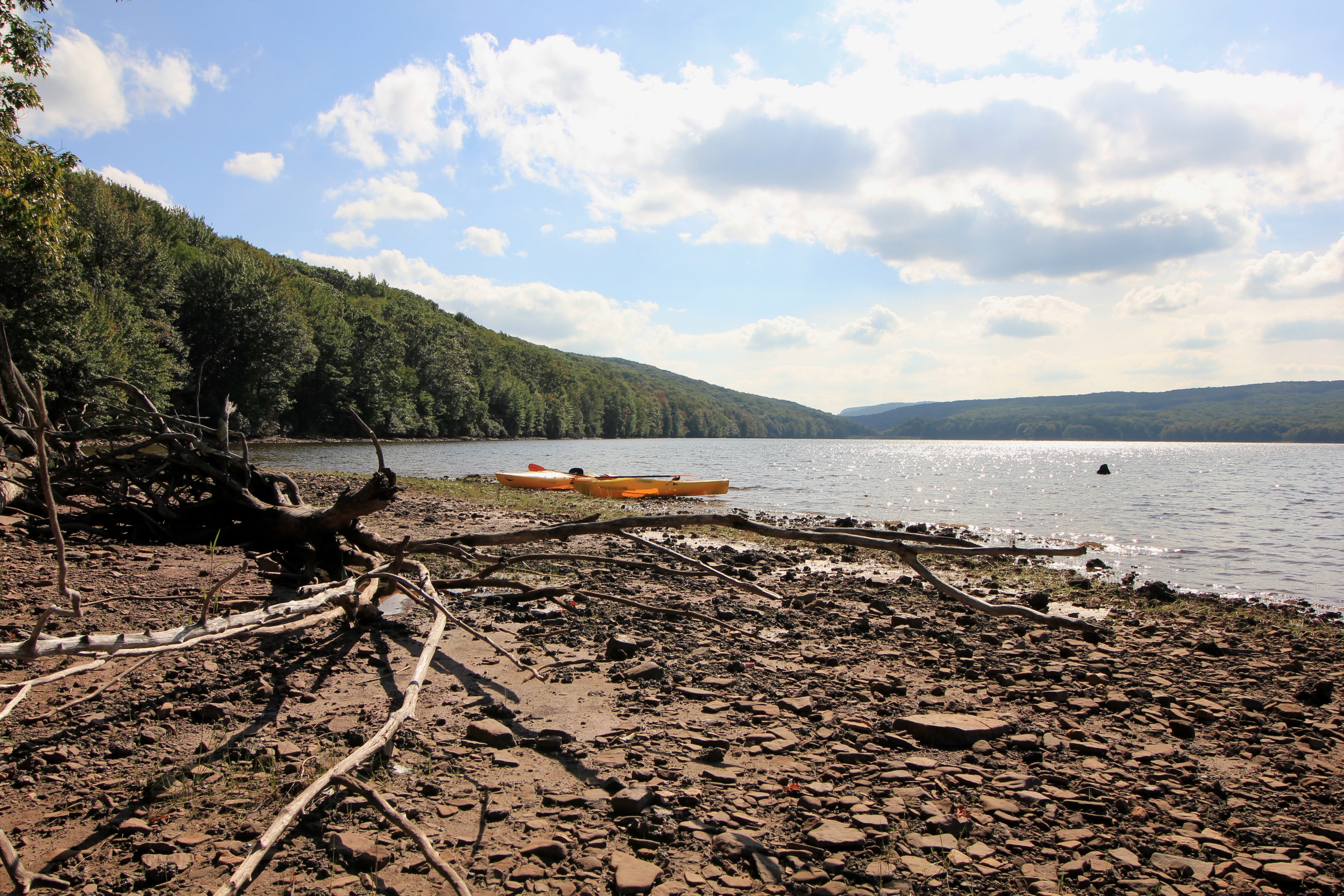
I would estimate that the lake takes about 3-4 hours to circumnavigate. Other than two boat docks, the lake is surrounded by wilderness. No camping is allowed near the lake, so the shoreline is undisturbed and pristine. Paddling on this lake, you can easily imagine yourself somewhere in the remote wilderness of Canada or Maine.

We stopped in a couple of spots to rest and enjoy the sun. We saw all manner of wildlife: jumping fish, hundreds of frogs, ducks, blue herons, a hawk, other birds we could not identify, deer, and a lone bald eagle soaring high in the sky above the lake. There were also signs of beaver along the shoreline.
Generally speaking, one side of the lake features rhododendron and has a steeper bank, while the other side features more wetland areas. The Virginia Department of Game and Inland Fisheries has set up some bird nest areas along the wetland side of the lake.

This is a gem of a lake, one we would like to visit again in the fall when the colors are changing. We were there during a weekday, but the trip to the lake takes so long that I doubt it is ever extremely busy. At one point there were about four boats on the lake, but by the evening we literally had the lake to ourselves. It’s pretty amazing in this day and age that you can have a 330 acre lake to yourself on a nice day.
This is, however, a place you really want to have to visit, as it’s very much out-of-the-way compared to many other outdoor spots in Southwest Virginia. But if you have the time, it’s a worthwhile trip. I know we’ll be back.
Because of its prominence, Clinch Mountain affords some of the best views over the Holston River and Clinch River watersheds. The best views are available during the winter when there is no foliage. On clear winter days you can see almost 100 miles south. On Saturday, February 22, 2014, I drove to the Hidden Valley Management Area and hiked the southeastern section of Clinch Mountain on access roads and trails in that area.
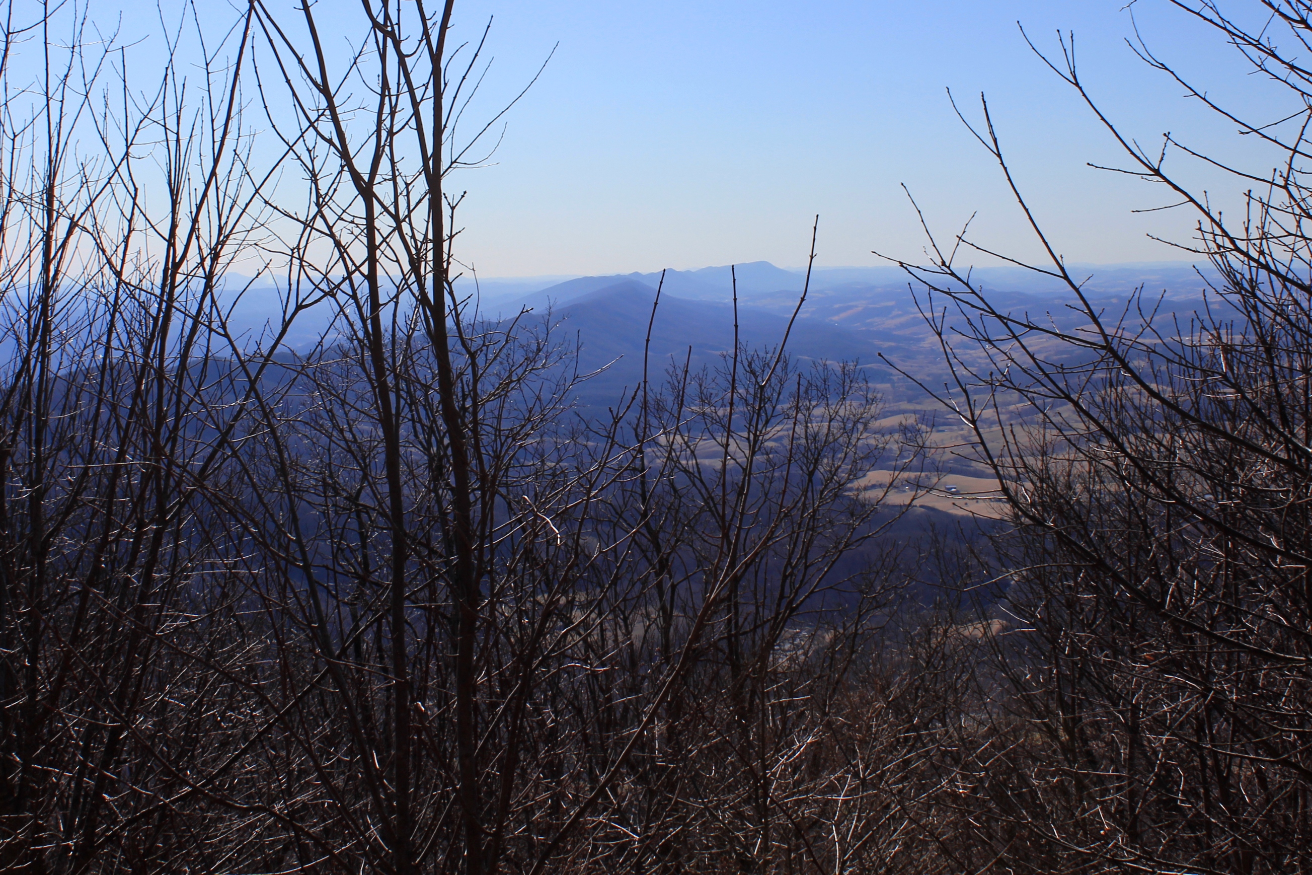
Clinch Mountain overlooks the small community of Hansonville and Moccasin Creek. Clinch Mountain divides two significant river basins: the three forks of the Holston River drain the valleys to the east and south of the mountain (which is to the left of the ridge in the photos), and the Clinch River to the west and north of the mountain (which is to the right in the photos).

In the photo above, the view shows the spine of Clinch Mountain to the southwest, and further to the south the valley through which I-81 travels, with the Iron Mountains (and Holston Mountain) bordering the other side of the valley, with the much higher Unaka Mountains (including Roan Mountain) on the horizon.

The western side of Clinch Mountain hase similarly long range vistas, with some cliff outcroppings. On this hike, however, I stayed on the southeastern side of the mountain.

In the photo above, Clinch Mountain is on the left, and the much smaller hill on the right is Big Moccasin Ridge. Together they frame in the Big Moccasin Creek and the valley.
Immediately above the confluence of Little Brumley Creek and Brumley Creek on Clinch Mountain is a unique 16-20 foot plunge-type waterfall known as Little Brumley Creek Falls.

This past weekend some friends, my son, and I hiked, climbed across mountainsides, and otherwise bushwhacked through state forest to reach this remote waterfall.
This waterfall is unique in that the waterfall drops over a huge slab of overhanging rock. There is a shallow cave behind the falls. You can actually get up in the cave and walk behind the falls.

Here is some footage of my son and another person in our party walking behind the falls:
There have been more bald eagle sightings in Southwest Virginia this fall and winter. The sightings are becoming more widespread. I have heard first-hand accounts of bald eagle spottings at Hidden Valley Lake and at Clinch Mountain Wildlife Management Area, as well as on private land in Washington County between Abingdon and Damascus. Here is a photo my brother-in-law James Bear took of two eagles in December:

The increase in bald eagle sitings was also recently profiled in a local article:
Sightings of bald eagles are still rare enough that people like Osborne and his neighbor are excited to spot one. However, Boynton, a bird watcher himself, says if individuals know where to look, it’s not difficult to see a bald eagle in Southwest Virginia or Smyth County.People regularly spot bald eagles, Boynton said, at Laurel Bed, Claytor and South Holston lakes as well as along the New River. In Smyth County, the wildlife biologist said, eagles can be seen along the Middle Fork and at DGIF’s trout hatchery on Rt. 16 and some private trout farms.
While the bald eagle’s presence has been growing in the region for some time, Boynton did note a new observation that now some nests are being located in Southwest Virginia.
SWVA Today, November 30, 2012 (online).
Thanksgiving is tomorrow. During this time we often reminisce and reflect on what’s happened in the past year and give thanks for the good things we have in our lives. Along the themes of reminiscence and reflection, here are some tranquil, reflective photos from a trip my son Karl and I took to Hidden Valley Lake one evening in this November.

We approached the eastern side of the lake just as a series of interesting cloud formations developed in the otherwise clear evening sky. The lake was very still—there was no wind—and the reflections looking back toward the sun were magnificent. (Click on any of these photos to enlarge them.)

The leaves had already mostly fallen, but as can be seen in the above photo, there were still oaks on the far side of the lake that clung to some of their dark auburn foliage.

We were the only two people in the valley. There was absolute quiet except for the sound of the rushing water in the distance at the dam.
The air was crisp and had a unique, slightly sweet scent. I have since come to learn that Hidden Valley at one time may have been a high elevation bog. There are some unusual plants in the valley that give off the unique scent in the late fall. I have discussed with Virginia Game and Inland Fisheries that it may be Possum Haw aka Shawnee Haw or Nanny Berry, or it may even be the bark from some of the trees after the leaves have fallen and they are more exposed to the air and sun.
Karl and I went for a hike to explore upper Brumley Creek. The creek’s headwaters are formed from the lake’s drainage, high elevation springs, and smaller creeks in the valley.
Upon our return, most of the clouds had rolled away. In the stillness of evening, the lake made an almost perfect reflecting pool. Faint light and muted features caused the scene to look like an impressionist painting:
Reflecting back on this year, I’ve spent a lot of time in the outdoors with my family. That’s one thing, among many other things, for which I am thankful.
Bigfoot has been sighted in Southwest Virginia. Apparently often. Usually associated with the mountains in the Pacific Northwest, there have been encounters with bigfoot, or sasquatch, all across this country.

Earlier last month, I was finishing a hike with a client when we saw an 8′ tall, fur-covered, man-like creature stop on the trail about 100′ in front of us. Standing but slightly hunched, it turned its head slowly and looked back at us, barred its teeth, and then quickly lumbered away down the hill out of sight.
Neither of us had our cameras ready. It happened so fast we were not able to get a photograph of the creature. Dumbfounded, shocked, and in fear, we just stared down the trail and then back at one another.
Actually, that’s not what really happened.
Earlier last month, I was finishing a hike with a client when we learned that Animal Planet was getting ready to film a new episode for the second season of the TV show Finding Bigfoot in Southwest Virginia. This is what really happened:
As we were arriving at the gravel parking lot, a large, white SUV drove up to us. The blonde driver stated, “Hi, I’m a TV producer from Los Angeles, and I’m trying to find out some areas to shoot footage for our television show.”
He pointed to where we were hiking. He asked, “Do you know who owns this property?”
My client stepped forward. She said, “I do.”
Then, gesturing towards me, she said, “And he’s my lawyer.”
So our conversation began. We talked for a while, and we learned he was one of the producers of Finding Bigfoot.
Last week, the local newspaper reported that the TV show had a “casting call” of sorts, where they interviewed individuals who believe they have encountered bigfoot in our region. According to the Washington County News:
After a short introduction by the show’s cast, the floor was open for local residents to tell their best Bigfoot stories on camera. Most of the witnesses’ stories had the common theme of spotting an extremely tall, broad-shouldered figure while hunting in the woods. One of the hunters was a man from Piney Flats, Tenn., who told a detailed story about how a large, dark figure with long, matted hair walked up to him, looked at him for a moment, then walked away in a zigzag motion.
“With my hand up to heaven I know what I saw,” the man said after he told his story.
A teenager from Saltville told a story about how she saw the familiar dark figure at the top of a hill outside her home, and soon after she made eye contact with it she was hit by a rock that left a sizeable bruise on her right leg. She even brought in a drawing of the creature to show to the cast.
The phenomenon of the fascination with bigfoot is itself fascinating. Like other paranormal phenomenons, such as UFOs, opinions on the existence of bigfoot are polarized. Either you believe they exist, or you think those who do are freaks.
Those who believe in bigfoot argue that bigfoot’s existence without definitive human knowledge is not that far-fetched: There are other phenomena−far larger phenomena−that have existed without human knowledge through the ages. For example, until the last 10-15 years, many of the world’s tallest waterfalls remained unknown to humankind (the 3rd, 5th, and 16th tallest waterfalls were only recently discovered). If such large geographical formations could remain hidden, is it not possible that an intelligent humanoid could covertly exist in remote areas of the country?

The phenomenon of bigfoot sightings is world-wide. Individuals around the world swear they have seen the humanoid cryptid. In Europe the creature has been known through the ages as the “Wildman”; in Asia it is known as the “Yeti” or the “Abominable Snowman”; in Oceania it is known as the “Yowie.”
The great climber, Reinhold Messner, spent several seasons in the Himalaya and had an encounter with the Yeti. Messner wrote a book about it, My Quest for the Yeti. Messner ultimately concluded that the Himalyan Yeti was most likely a bear.
Perhaps most, if not all, human encounters with bigfoot could be explained in some similar fashion−misconceptions about what people saw or thought they saw.
In Virginia, there are several organizations dedicated to bigfoot research. The Virginia Bigfoot Research Organization boasts of “combining scientific methodology with shamanistic awareness in the hopes of establishing peaceful contact.” Based in Northern Virginia, VBRO has a large list of encounters with bigfoot in the Commonwealth organized by region. There are numerous sightings in Southwest Virginia. Sasquatch Watch of Virginia, another organization, “conducts initial field investigations and field research within areas of reported encounters or habitual recurring encounters.”
One website purports to map all of the confirmed bigfoot encounters in the United States. From my review of the maps, there are more bigfoot sightings in the Eastern United States than in the West. There are numerous encounters near New York City.
Which brings us to the penultimate question in this article. Hypothetically, if there are bigfoot in Southwest Virginia, where would they most likely be?
My guess would be up on Clinch Mountain, in the Mount Rogers National Recreational Area, or somewhere near the Virginia-Kentucky state line near Breaks Interstate Park. These are the most rugged areas of this part of the state, where the squatch could reside with fairly large ranging areas and yet hide from humans.
So, is there a squatch in these Southwest Virginia woods? I can’t wait to hear the testimonials on the TV show and find out. And next time you are in the outdoors, be extra aware. Oh yes, keep your cameras ready, too.
This past Sunday afternoon my sons Isaac, Karl and I went for a five mile loop hike on the Iron Mountain Trail / Forest Road 84 off of State Route 600 in Smyth County. These photos were taken at the Skulls Gap scenic parking lot, which is about 3500′. The colors are starting to change at higher elevations and all foliage is taking on that golden hue in the evening that signals autumn has arrived. Click on any of the photos to enlarge to appreciate the panoramic views.


This photo taken with a point-and-click camera shows Brumley Creek the day after the heavy rains from Tropical Depression Lee last week. Normally, this creek is only about 10 feet wide during low water. As a point of reference in the photo, the distance from the bank on the right side to the large tree in foreground in the middle of the creek is about 15 feet (and the width of the stream from the tree to the other side is at least about another 10-15 feet).

We went down to the creek in the evening to look around, and to see how high the water would have risen from the storm water runoff. Usually this section of the creek is quiet, but there was a roar from the water that you could hear as soon as you opened the car door.
How do trout survive in such a rapidly changing environment? This week over at the Orvis Fly Fishing Blog Drew Price explains. Simplifying the explanation, the torrential flow we view from surface is moderated at the bottom, and there are places where the fish can hold and stay safe.
A little bit about Brumley Creek: Technically, it is the closest trout stream to Abingdon. It’s a small stocked creek less than 10 miles from town. It doesn’t have a reputation for producing large or many fish, as there are not many holdovers from the previous seasons. It’s also not regulated, i.e., it’s open to all fisherman who hold a trout license during the stocking season. As stated above, it’s also small. It’s still a pretty little creek though.
Note that this description is of the stocked lower section of the creek, which has about 1/2 mile or so of fishable water, on Trout Road. The creek flows from Hidden Valley Wildlife Management Area and down off of Clinch Mountain.
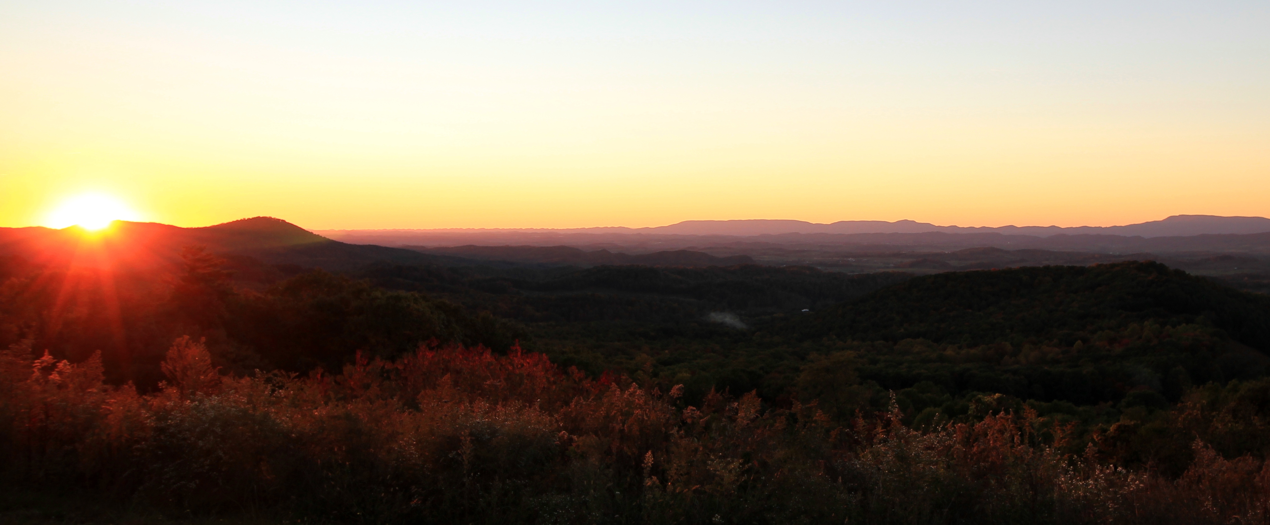
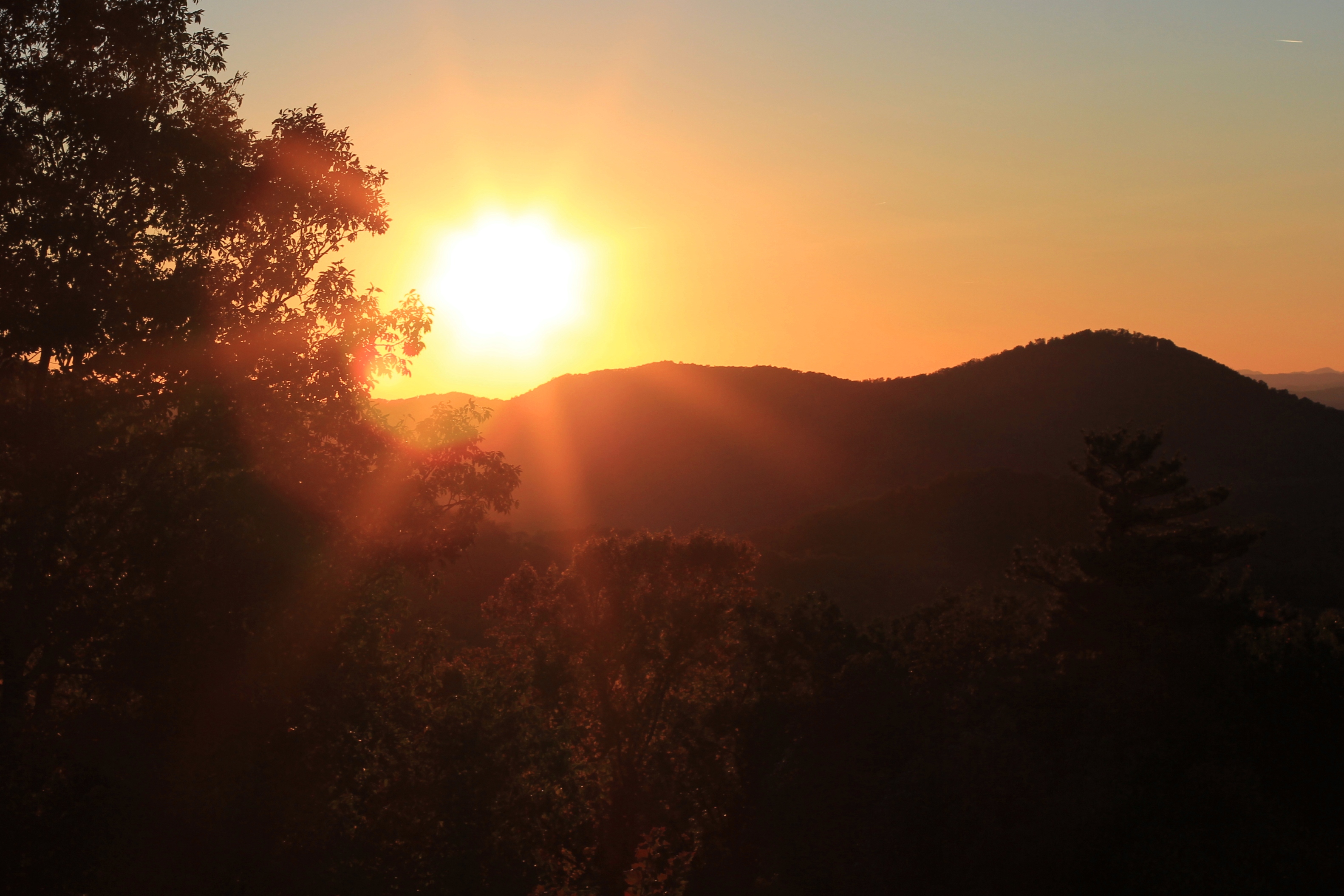
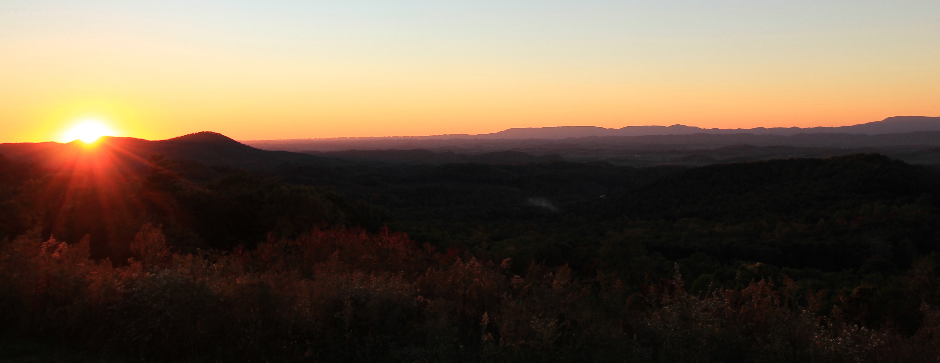
On Sunday, May 22, 2011, a set of late evening thunderstorms came through Abingdon. They left in their wake an unusual reddish hue in the sky, more of an Alpenglow than we ordinarily have in this region (especially for this time of the year). From our house you could see the sky change from dark grey, to burgundy, to red, eventually to a reddish orange. My son Karl and I hopped in the car and hastily drove to some vista points to capture the post-storm sunset, as there were only about five minutes left in the evening to capture the skylight.

Landscape photography is something I have always enjoyed and is an interest my son and I have shared for the last year or so. This winter he received a camera which he has been using on our trips outside. In addition, we have become fans of From the Edge, a photography show on The Weather Channel with landscape photographer Peter Lik. In From the Edge, Lik travels to beautiful areas of the United States, primarily our National Parks, and demonstrates photographic techniques. The show at times is a bit over the top, and Lik may exaggerate somewhat how dangerous some of the situations are, but the man is exuberant, the show is entertaining, and the photography and cinematography are gorgeous.


On this evening Karl and I were able to have our own “Peter Lik” moment inside of town limits as we raced to the west side of Abingdon to get these shots before the light changed. As the photos show, to the west the sky was a fiery red with heavier cloud cover framing a shrouded sunset.

