Category Archives: Cycling

To the North Pole

This night I did an evening mountain bike ride on the Virginia Creeper Trail.  The sky was clear and the air was cold.

November Moon and Jupiter over Norfolk Southern Railroad, Abingdon, Virginia

Crossing the railroad tracks on Pecan Street, a gigantic November moon appeared to rise directly over the tracks.  By the time I got home and got my camera, the moon had moved slightly and was not quite as dramatic, but still impressive.

In the photo above, Jupiter appears as the largest star in the sky and is to the right over the moon.  Airline contrails reflect the moonlight in both the foreground and background on a northeastern axis, while railroad tracks glisten from the street lamps in town on a northeastern axis.

The scene is reminiscent of The Polar Express, in which children take the train through the night to the North Pole.

The New River, Part II: Camping and Fishing at Foster Falls

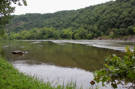
This is the second article in my short series on the New River.  This summer we canoed and fished several sections of the New River, first exploring the upper section in North Carolina, then the middle section that flows through Virginia, and finally the section that flows through the New River Valley and into West Virginia.  In the first article, I reviewed the section of the New River below the confluence of the North and South forks of the river.  This article is about our second trip where we fished and camped at Foster Falls in August 2011.

The Cliff at Foster Falls
Shallow Water and Rocks Visible at the Falls

The New River leaves Ashe County and Alleghany County in North Carolina and crosses the state line and flows into Virginia at Mouth of Wilson in Grayson County.   It then briefly crosses back into North Carolina and then back into Virginia again near Fries, Virginia.  The river then flows through the eastern part of Grayson County and into Wythe County.  As the river flows through the eastern part of the Appalachian Mountains in these counties it gains considerable volume and size as various tributaries add water to its flow.

Shortly after flowing under I-77, the New River has a series of step-like waterfalls that spand the entire width of the river and are collectively classified as a class 3 whitewater.  This area is known as Foster Falls and is the site of Virginia’s New River Trail State Park

Great Biking

The New River Trail State Park is a unique Virginia park: A 57-mile linear state park with various facilities located at different segments of the trail.  The main facilities are located at Foster Falls, where there is a small “walk in” campground, river access for fishing and a boat ramp, picnic areas, horse stables, and a canoe livery with a small shop.

The New River Trail itself is a converted railroad bed.  The trail is a packed dirt/ash trail that is excellent for mountain bikes or cross bikes.  The trail has several trestles that cross the river and also has a tunnel or two that cyclists travel through.  The trail is a level grade, with only a few minor hills, and generally follows the New River between Fries and Pulaski.  Foster Falls is the approximate half-way mark on the trail, and makes a good base camp to cycle in either direction on the trail. 

This trail is scenic with minimal traffic and road crossings.  After the Virginia Creeper Trail, it’s probably the nicest off-road cycling trail in Southwest Virginia.

Smallmouth Country

Low water allowed for great wet wading and fishing

The New River is renowned as one of the premier smallmouth fisheries in Virginia.  Actually, it’s one of the premier smallmouth fisheries in the United States.  The river also has large populations of musky and other game fish.  The New holds Virginia’s state records for largest smallmouth bass (8 pounds, 1 ounce) and largest musky (45 pounds, 8 ounces.) 

Isaac nabs a nice 14 inch smallie

There are several areas to fish right at Foster Falls.  I believe the key to fishing any large river, but especially the New, is to spread your casts methodically over fairly large areas of water to reach the most fish as possible and then move on.  Unless you are bait fishing and patient, covering a section of water and then moving on to another section is the best way to cover this river. 

We therefore first bank fished the river, then waded parts of the river where it was shallow and fished across a large island adjacent to the campground.  I fly fished with streamers and caught about 10 smallies with a size 8 olive wolly bugger.  My sons Karl and Isaac used Mepps and Blue Fox spinners on light and ultra light spinning tackle.  They caught about a dozen fish between them. 

Great Camping

Foster Falls campsite. The New River is seen right behind the campsite.

There are only 12 campsites at Foster Falls.  Thus, although it is a group camping area, the sites are dispersed and there is a wonderful absence of what I sometimes call the “Camp Jellystone Effect”−hundreds of sites jammed together creating a permanently smoky area that from a distance resembles a foreign refugee encampment as sometimes seen on the evening news.

The Falls Near the Camprground

Also, because these are “walk in” sites, there are no RVs or trailers.  You have to park in a designated parking area and carry your camp gear between 100-200 feet to the designated campsites.  This is not that difficult, and, much to my surprise, the state park provides little wagons for campers to transport their gear from the car to the campsites. 

"Walk In" Campsites

Most of the campsites are either right on the river, or very close to the river (with river views).  The camground also provides a sheltered area with dry wood for the campers.  You simply have to pay a daily fee, and then you may transfer the firewood to your site for your own use.  This was convenient and a reasonable way to provide firewood (if you run out, you simply go back to the covered area and get a few more logs).

Kayaking and Canoeing

Although we didn’t do any boating, there is the possibility of boating both up river and down river from Foster Falls.  Running the falls looked a bit sketchy.  When we were there in August, there did not appear to be sufficient water to successfully navigate the falls.  We saw one kayaker dragging his kayak down the river; it didn’t look fun.

I have kayaked the section of the river above the falls previously (my brother-in-law once took me down this section when a summer lightning and thunderstorm developed in which I feared for my life−getting caught on the water under these conditions can be scary).  During higher flows, this can be a moderately challenging kayak with lots of riffles and fast water, but there are not too many obstacles.  Downriver from the falls the river slows considerably as it approaches and eventually forms the upper part of Claytor Lake.

Kayaker Down River from Foster Falls

We will definitely return to Foster Falls, probably with a bike focus on our next trip.  However, I will also have to bring more marshmellows, Hersheys chocolate, and graham crackers next time.  Because this time, these ingredients seemed to mysteriously disappear each night.

Someone was stealing the S'mores. Who Was It?

Tour de Rocky Top: A Twisty, Thirst-Quenching Metric Century

The Tour de Rocky Top is a metric century ride in Knoxville, Tennessee organized by Race Day Events, a private race organization.  This ride is unique in this region in that it starts and finishes at a large pub, Barleys Tap Room.

I did this metric century on Saturday, July 2, 2011.  The ride went through downtown, across the Tennessee River, and out into the country to the south and east of Knoxville towards the Smoky Mountains.  The ride never got into the mountains, but had many rollers, totaling about 3,000′ in total elevation in climbing (and descending) in the 62 mile course.   There were three well-stocked aid stations on the ride.

The staging area for this ride was excellent.  It began right next to Barleys Tap Room.  Adjacent to the tap room is a six lane off-ramp/overpass.  The City of Knoxville has turned the area under the overpass into a very large parking lot.  This was a perfect area to park and leave vehicles in the shade while cycling.  The ride started cool but became quite hot.  Who would have thought riding in Knoxville in July under a noon sun could get hot?  On the negative side, there was no place to shower at the end of the ride.  You pretty much had to just change into street clothes next to your car or go into Barleys and use the restroom to do so.

This is definitely more of true “tour” than a race.  While there may have been a lead group pushing the pace at the front (I don’t know if there was or not since I was at the back side of the starting line), there were about 45 turns on the course.  Every time you got up to speed or began to proceed in a good rhythm it seemed like there was a turn.  And many of these turns were not your gradual “bear to the right or left” turns, but true 45 degree turns on small country roads, several at stop signs.  So this ride was not conducive to a personal best time record, but it was nonetheless a pleasant tour of the countryside around Knoxville.  The race organizers did a good job of getting the riders out of and back into the downtown area on roads with relatively slight traffic, which was impressive.

I finished the ride in approximately 4 hours.  Actual riding time was about 3 hours, 40 minutes.  The average speed on my odometer was 16.2 mph.

The ride ended on a great note.  The ride ended at Barleys Tap Room, a restaurant with excellent pizza in the old town section of Knoxville.    The Barleys in Knoxville is an open, unfinished warehouse with brick interior walls, large rough-hewn beams, and a nice garden patio.  Barleys had two large flat screen TVs showing coverage of the first day of the Tour de France.  Watching part of “the” Tour with several hundred fellow cyclists after doing a century ride was a nice way to start off the Independence Day weekend.

A note on getting to the ride:  The venue is about 1 hour, 50 minutes from Abingdon.  It is a straight shot down I-81.  It makes for an early morning to do the trip in one day.  There are several nice hotels in downtown Knoxville close to the race staging area, and there are lots of restaurants and boutique stores in this area of Knoxville.  Going down the evening before would probably not be a bad idea.

Big Walker Mountain and the 2011 Big Walker Mountain Century Ride

Big Walker Mountain is one of the most prominent mountains in Southwestern Virginia’s valley and ridge province.  From its rise as mere hill in Washington County (see my description of it in the Saltville Loop article), Big Walker rises to 3500’ above sea level,  and all the way from Saltville to the New River beyond Pulaski it is the main dividing ridge between the great valley that contains Route 11 and Interstate 81 and the valleys to the north.  In fact, it is so prominent and without any significant gap that the engineers who built I-77 created a tunnel to go through it.

The Southwest Virginia Cyclists use the primary and secondary highways that cross Big Walker Mountain for many of their training climbs.  They also sponsor two organized rides over the mountain each year, the Mother of a Metric and the Big Walker Mountain Century Ride

The Ride

This past weekend, Saturday, June 18, 2011, was the 8th Big Walker Century Ride.  The Big Walker Century has four ride options, including a metric century (100 kilometers) and an English century (100 miles).   This was the second year I did the metric century with a buddy from Abingdon.  There were about 100 riders who toed the start line in the morning.

The conditions turned out to be good for a long distance ride.  The morning started out cloudy, a bit chilly, and threatening rain.  As the ride progressed the skies cleared somewhat, and we had partly sunny weather for the tail end of the ride.  The ride starts and finishes in Wytheville.  The beginning of the ride this year began with a typical peloton mass start in downtown Wytheville at 7:30 AM.  There was a police escort for at least the first 15 miles.  This ride usually starts out at a pretty hard pace.  The local pack of Southwest Virginia Cyclists leads the peloton, and they are usually hammering pretty hard following the police car.  This year there were about 100 cyclists in the peloton.

This year involved an inauspicious start as I was cut off in the peloton by an errant rider within the first five miles.  I was driven off the pavement.  Like the famous decision of Lance Armstrong to take a short cut in stage 9 of the Tour de France in 2003 in order to avoid the crash with Joseba Beloki, or the quick decision of many professional riders to go off the pavé in Paris Roubaix to avoid crashes, I had to make a split second decision to avoid a crash and went off Route 11 at 30 mph.  I drove into the gravel shoulder and feathered my brakes to slow, standing on the pedals and leaning back so as not to endo.

While I was fortunate the incident occurred where there was a shoulder that allowed me to decelerate without flipping or crashing, I was unfortunate in that it occurred on a stretch of road just before the beginning of a long hill.  With adrenaline pumping and my heart pounding, I came to a stop, looked up, and saw the back peloton receding towards the distant top of the hill.  Having lost contact with the peloton and with no forward momentum, I then realized I would have no draft for next 15 or so miles to the base of the climb; the lead pack was gone, not be seen again for the rest of the ride.  I eventually caught up with my buddy James, and we rode the rest of the ride more or less together.

The Climbs

The climb up Big Walker Mountain on Rt. 52 is a moderately difficult climb of 1000 vertical feet at a 5% gradient (from 2400’ to 3400’).  The climb takes 30-45 minutes.  The gradient is consistent—there are no very sharp spikes in the gradient, thus allowing a cyclist to get into a good rhythm.

Coming from Wytheville, when you reach the top of the mountain on the metric century ride you go left (west) down Old Mountain Road, aka County Road 621, which is a narrow single lane road with great views down the valley.  County Road 621 actually resembles many of the mountain roads in Europe with its solid white lines on both sides and proximity to the side of the mountain, sometimes without any guard rail to prevent going off the side.  (Last year the organized ride went right at the top of the mountain continued down Route 52.) 

The most scenic part of the ride is definitely on the north side of the mountain in Rich Valley.   The valley is fairly narrow with mountain scenery on both sides.

The climb up the backside (north side) of the mountain on Route 52 is about 700 vertical feet at a 5.2% gradient (from 2700’ to 3400’).  The gradient on this climb is also consistent.  This is just a bit steeper climb with tighter switchbacks than the climb up the south side.

We finished the ride in 3 hours, fifty minutes at an average speed of 16.4 mph.  We also spent about 20 minutes out on the course stopped at aid stations; they were well-stocked and had lots of goodies for re-fueling.

Training on Big Walker

I have done the Big Walker Mountain climb many times on my own without any organized ride.  This is one of the best training rides in Southwest Virginia.  Route 52 has a good, steady gradient and is generally wide for a mountain road in this region. The climb is similar to the climb over Route 421 near South Holston Lake in Bristol, Tennessee.

One way to approach this climb without riding on Route 11 (the busiest stretch of the organized century ride) is to start in Rural Retreat, Virginia (Rural Retreat is ½ mile to the south of Exit 60 on I-81).  Park in one of the municipal parking areas or church parking lots in downtown Rural Retreat. 

From your starting location, take Main Street north back towards the Interstate.  You ride under the I-81 at Exit 60 and will be on Black Lick Road, aka County Road 680.  Continue north on Black Lick Road.  Black Lick Road eventually junctions with Route 52.  Make a left on Route 52 and you will approach the Big Walker Climb.  Once you reach the top of the mountain you can go down the backside, or simply return back to Rural Retreat.  From this point you can follow the directions from the cue sheet from the organized ride, which is set forth below.

At the top of the mountain there is the Big Walker Country Store.  This is good place to refuel.  There is also a lookout on the north side of the mountain and some scenic vistas from the store itself.

Cue Sheet for Big Walker Mountain Metric Century Ride

Start                      Head southwest on S Main St toward N 4th St 

0.43mi                  Turn right onto N 12th St 

0.43mi                  Head northwest on US-11 S/N 12th St toward W Monroe St Continue to follow US-11 S

1.1mi                     Slight left onto US-11 N/W Lee Hwy 

13.19mi                Turn right onto Kimberlin Rd/State Route 682 

13.2mi                  Head north on Kimberlin Rd/State Route 682 toward Mt Airy Rd/State Route F-015 

14.2mi                  Head northeast on Kimberlin Rd/State Route 682 toward Ridge Top Dr

Continue to follow Kimberlin Rd

16.41mi                Turn left onto Blacklick Rd/State Route 680 

16.42mi                Head north on Blacklick Rd/State Route 680 

18.53mi                Turn left to stay on Blacklick Rd/State Route 680 

19.18mi                Turn left to stay on Blacklick Rd/State Route 680

Continue to follow State Route 680

23.51mi                Turn left onto U.S. 52 N/Stony Fork Rd (Note this is the junction I describe in the alternative trip from Rural Retreat)

23.52mi                Head northwest on U.S. 52 N/Stony Fork Rd

Continue to follow U.S. 52 N

30.81mi                Head southeast on U.S. 52 S/S Scenic Hwy W toward Old Mountain Rd/State Route 621 

30.82mi                Turn left onto Old Mountain Rd/State Route 621 

33.66mi                Head west on Old Mountain Rd/State Route 621 toward VA-42 E/W Blue Grass Trail 

33.76mi                Sharp right onto VA-42 E/W Blue Grass Trail 

38.69mi                Head east on VA-42 E/W Blue Grass Trail toward U.S. 52 S/S Scenic Hwy 

38.7mi                  Turn right onto U.S. 52 S/S Scenic Hwy 

39.41mi                Turn left onto State Route 617/Waddletown Rd 

39.42mi                Head west on State Route 617/Waddletown Rd toward U.S. 52 N/S Scenic Hwy 

39.43mi                Turn left onto U.S. 52 S/S Scenic Hwy

Continue to follow U.S. 52 S

42.87mi                Head east on U.S. 52 S/Stony Fork Rd

Continue to follow U.S. 52 S  (Note that if you are going back to Rural Retreat, you need to watch for Black Lick Road, aka County Road 680, after coming off of the mountain, you would make a right onto Black Lick Road and follow it back into Rural Retreat)

53.04mi                Head east on N 4th St toward W Ridge Rd 

53.04mi                Turn right onto W Ridge Rd 

53.92mi                Head southeast on W Ridge Rd toward N Petunia Rd 

55.97mi                Turn left onto N 4th St 

55.97mi                Head southeast on N 4th St toward W Ridge Rd 

55.98mi                Turn left onto W Ridge Rd 

56.09mi                Head northeast on W Ridge Rd toward Tazewell St 

56.1mi                  Turn right onto Tazewell St 

56.44mi                Turn right onto W Spiller St 

56.44mi                Head southwest on W Spiller St toward N 4th St (you are in downtown Wytheville)

Saltville Loop

This is the second installment in a series on cycling routes near Abingdon.  The “Saltville Loop” is one of the more often ridden, middle-length cycling loops in Abingdon and Washington County.  It is popular because the roads are relatively low in traffic (especially the backside of this loop) and have only a few moderate climbs.  Below is a further description and directions for the ride.  Click on any of these thumbnail photos to expand them.

Distance:  Approximately 46 miles

Time:  Approximately 3 hours @ about 15 mph

Difficulty Notes:  Some moderate climbing on hills; big rollers, especially on the middle section of the first half of this route

The Saltville Loop is one of the major training routes used by the local cyclists in Abindgon.  The route generally follows the valleys between Abingdon and Saltville, which is in Smyth County.   Because the route generally follows the valleys, there is only one sustained climb, which is on Route 80 from the intersection with the North Fork of the Holston River back up to Old Saltworks Road.

There are some beautiful farms on Old Saltworks Road.  After about 8 miles into this ride, the hill that parallels Old Saltworks Road on your right (immediately to the south of the road) that gets higher and higher is the beginning of Big Walker Mountain.  Further to the east, towards Marion, Big Walker Mountain rises to almost 3500′ above sea level.

Poor Valley Road on the way back from Saltville provides excellent views of Clinch Mountain.  Coming from Saltville, after about 5 miles on Poor Valley Road you will pass Big Tumbling Creek and the Clinch Mountain Wildlife Management Area, one of the largest wildlife management areas in the Commonwealth of Virginia with over 30,000 acres.

This route starts in downtown Abingdon at the Jockey Lot of the county courthouse or as an alternative may start at the Coomes Center. 

Directions

  1. From downtown, travel on Valley Street east until it turns into Walden Road.  From the Coomes Center, make a right out of the Coomes Center and travel down to Walden Road.  Make a right on Walden Road. 
  2. Travel on Walden Road until you intersect with Old Saltworks Road (also known as County Road 740).  Turn left onto Old Saltworks Road.
  3. Travel on Old Saltworks Road until you reach the T-bone junction with Route 80.  Turn left here onto Route 80.
  4. Travel for about 1 mile.  You will approach an area of open fields.  The road makes a fairly sharp left turn at this point.  About 100 yards past this point there is a junction with Old Saltworks Road, aka County Road 745.  There is a sign for Saltville.  Turn right here to stay on Old Saltworks Road, aka 745.
  5. This road travels through the community of Clinchburg, and then continues into Saltville.  There is another junction with Route 91.  Turn left onto Route 91 which goes into Saltville.  This is about a 20 mile ride at this point.  Saltville is a good place to take a rest break and refuel if necessary at one of the gas stations with some water or sports drinks.
  6. Route 91 is Main Street.  One of the first roads as you enter into Saltville is Bank Street.  Make a left onto Bank Street.
  7. Bank Street turns into Allison Gap Road.  Continue on Allison Gap Road, aka County Road 634, as it leaves town.  Allison Gap Road eventually makes a junction with Poor Valley Road.  Veer to the left and stay on Poor Valley Road, aka County Road 613.  Poor Valley Road is a long, generally flat road that parallels the base of Clinch Mountain for about 10 miles. 
  8. Poor Valley Road eventually junctions with Hayters Gap Road, aka Route 80.  Stay to the left on Route 80 which continues parallel to Clinch Mountain (a right here would take you up the south side of Clinch Mountain, one of the largest climbs in Washington County and the subject of a future article).
  9. Route 80 will take you through the community of Hayters Gap—just a church, schoolhouse, and a few homes), and then goes downhill and follows Wolf Creek until you intersect with the North Fork Holston River.
  10. Stay on Route 80.  At this point the road turns up for the only lengthy climb, about 2 miles at a consistent 4-6% gradient, until it tops out in the community of Lindell.  This is the main climb on this ride.
  11. Stay on Route 80 as it continues through the large area of open fields you passed on the way out.  You will pass the junction for County Road 745 on the way out; however, stay on Route 80.  From this point, you now simply retrace your route back to Abingdon. 
  12. You will eventually come back to the junction with Old Saltworks Road, aka County Road 740.  Make a right back onto Old Saltworks Road.
  13. Make a right when you reach Walden Road.  Take Walden Road back into Abingdon and the start of your ride.   

There are several alternative ways to come back from Hayters Gap.  The main cycling roads between Abingdon and Saltville, Old Saltworks Road and Poor Valley Road, are described here.  These roads combined with the other connector roads described herein make for a good approximate 46 mile training ride.

Another alternative route is to do the whole route in reverse, i.e., in a clockwise fashion taking the route from Abingdon to Saltville via Poor Valley Road first and then coming back to Abingdon via Old Saltworks Road.  Coming back from Saltville, a good alternative to hilly Old Saltworks Road is to leave Saltville and take Old Saltworks Road until the junction with Old Mill Road, aka County Road 750.  Turn left onto Old Mill Road.  Old Mill Road will take you all the way to the Town of Glade Spring, where it junctions with Hillman Highway, aka County Road 609.   Turn right on Hillman Highway, and it will take you back to Main Street in Abingdon.  This is a fast route. Note that Hillman Highway can have higher traffic than the other route described above.

Maiden Creek Loop

Distance:  17 miles

Time:  Approximately 1 hour, 10 minutes @ 15 mph

Difficulty Notes:  Moderate climbing on hills

This will be the first installment of numerous cycling route reports from Abingdon, Virginia and the surrounding areas.   Maiden Creek Loop is one of the shorter loop road bike rides available from Abingdon.   It is approximately 17 miles in length over rolling roads with a few small climbs.  It generally has low vehicular traffic.   

Most of the routes I shall describe in the following installments are loop rides, that is, rides where the route is a circular or square loop trip of some sort with minimal doubling back on the same roads.  I prefer loop rides because the scenery during the ride is fresh during the entire ride.  In addition, there is a certain sense of satisfaction in completing a journey (or approaching the completion of a journey) with a loop trip that is different than in doing an out-and-back trip, regardless of the distance.

The Maiden Creek loop starts in downtown Abingdon.   For reference, most the rides I will report start in downtown Abingdon.  Perhaps the best reference spot is the so-called Washington County Courthouse “Jockey Lot,” the parking area immediately behind the courthouse at the intersection of Court Street and Valley Street.  This has traditionally been a meeting spot and point of reference in Abingdon going back well over 100 years.

The ride begins on Valley Street going east.  The first left down Valley Street is Whites Mill Road.  Take this left onto Whites Mill Road.  This road is flat and then gently ascends until the intersection with Chip Ridge Road.  Stay on Whites Mill Road.  From here, Whites Mill descends rapidly, all the way to Whites Mill, an historic mill about three miles from Abingdon.  The initial descent on Whites Mill from Chip Ridge is significant.  I have accelerated to almost 50 mph on this descent, and speeds in excess of 42 mph are easily obtainable without pedaling.  You will pass farmland and pasture on your left.  As you descend Whites Mill there are also excellent views through the hills of Clinch Mountain in the distance directly in front of you.

At the mill the road veers to the right and intersects with Rich Valley Road.  Take a right on Rich Valley Road.  This is a rolling road that generally travels east along the valley floor between two ridges.  Note that to your left (looking north) you can catch additional glimpses of Clinch Mountain in the distance.  After approximately 5 miles, you will intersect with Maiden Creek Road. 

Take a right onto Maiden Creek Road, which ascends following Maiden Creek to the right as you go uphill.  The road here is not in the best condition but is fine for a road bike.  Note there are numerous little riffles and small waterfalls to your right as you ascend.  The creek’s flow varies and is sensitive to rainfall as it mostly runoff from the hills at the top of the road, yet at times the little falls are quite pretty.  At the top of the initial climb, about two-third the way up the road, there is a little descent and then a false flat that gradually ascends to end at the intersection with Old Saltworks Road. 

Make a right at Old Saltworks Road.  Old Saltworks continues to ascend for about a half mile, and then mostly descends until the intersection with Walden Road.  Make a right on Walden Road, this road ascends for about two miles and then descends until it rolls back into the town limits of Abingdon.  Continue on this road, which eventually turns into Valley Street.  Continue on Valley Street until you are back at the courthouse.

Maiden Creek loop can be completed in approximately 1 hour, ten minutes at a pace of about 15 miles per hour.  At 15 mph the workout should be a moderate one, but is not “noodling” by any standard.  The rolling nature of this course, like many in Southwest Virginia, will result is slightly slower times than what you would expect in flatter sections of the country.  This route as set forth above has the advantage of all right turns, so there are no turns crossing traffic.  Traffic on this route is usually low, with the most traffic within a mile or two of town and on the section of Old Saltworks Road.  There are times you may encounter less than a half-dozen vehicles on this loop (excluding traffic in the town limits of Abingdon).  There are occasionally farm tractors on this loop, particularly on Rich Valley Road.

An alternative end of this route is instead of taking a right onto Walden Road, continue on Old Saltworks Road until it ends at Hillman Highway.  Make a right at the junction.  There is a steep little climb up on Hillman Highway immediately after you make the right.  Be careful here as vehicles coming in the opposite direction cannot see you ascending, and drivers behind you may be impatient and illegally attempt to pass you without being able to see oncoming traffic.  Once you climb this little rise, Hillman Highway will take you back into Abingdon in about the same time as Walden Road version of this route.  Hillman Highway ends at the junction with Main Street.  You can ride Main Street back into town towards the courthouse.

This route may also begin and end at the Coomes Center, Abingdon’s recreation center.  To begin the route from the Coomes Center, make a right leaving the Coomes Center past E.B. Stanley Middle School.  At the junction with Walden Road make a left.  Ride Back through to Valley Street and make a right onto White’s Mill.  From here the directions are the same as described above.

Time in the Outdoors

Recently my minister gave a sermon that explained the concepts of chronos time and kairos time.  Chronos time is that time measured by the clock.  Kairos time, on the other hand, is the concept of the Lord’s time, which does not correspond to chronos time and may not be measured.  Kairos time is metaphysical and beyond human comprehension.  This concept goes back at least to Greek times, when it was understood that time could be more than a measured unit.

In our modern age, chronos time is what drives us both at work and home.   We constantly confront deadlines, whether imposed by a third-party, our boss, or ourselves.  In my profession, for example, the court sets deadlines in litigation for filing lawsuits, filing papers, scheduling these cases for hearings and trials, etc.  Clients set deadlines for projects and transactions.  My profession also measures my worth, or value, based upon chronos time.  For most legal work, the billing unit is tenths of an hour, or six-minute increments of time.  

Most jobs are similar in that meeting deadlines and time spent on the job wholly or to some extent measure performance.  Scheduling and time commitments are also ubiquitous aspects of personal life.  There is always so little time and so much to do.  Indeed, in an increasingly busy, complicated and technological world, even “finding time” to be outdoors can be difficult.

In most outdoor sports, chronos time determines victory or measures success.  Whether racing against a competitor or directly against the clock, we are competing in chronos time.  When we race, we are conscious—usually very conscious—of the passage of time.  We wear watches that can keep track of it down to the hundredth of a second, and we time ourselves even in training.

We also, however, can experience kairos-like time in the outdoors.  Upon reflection I believe this may be one of the most important reasons those of us who are attracted to the outdoors spend time there.  In the outdoors time can become metaphysical.  The beauty of outside and our exertion somehow converts ordinary chronos time to kairos-like time or at least may allow us to experience something akin to kairos time. 

Reinhold Messner, the great mountain climber who has spent as much time alone in the mountains as anybody, has stated that while climbing his perception of time could become altered.  Messner has reported that while climbing he has had conversations with his deceased brother, and that at times when at altitude his entire existence seemed to be reduced to nothing more than a single, breathing lung.  Reading through literature, it is apparent that mind-altering or other virtual out-of-body type experiences like this are not that uncommon among extreme outdoor athletes, especially when they are alone and in remote areas.  They also almost universally experience kairos-like time.

A friend of mine who hiked the entire Appalachian Trail once told me that his journey completely altered the way he experienced and viewed time.  “Time was meaningless for me on the trail,” he told me.  This was one of the most memorable and important experiences of his 2000+ mile journey.  When I run, time may become slower and faster—sometimes simultaneously.  Time can seem to palpably slow as my mind relaxes, clears and yet races through thought.  For example, I wrote this entire essay in my mind within a one mile section of the Virginia Creeper Trail while running. 

When we get in “the zone”—and all endurance athletes know what this means—time as we ordinarily experience it is altered or may even seem to stop altogether.  In “the zone” there is a zen-like state of mind, feelings of a sort of euphoria, and temporal freedom.  Our mind relaxes until there is only the pleasantly repetitive, meditative stride while hiking or running.  While cycling, there is only the trance-like pedaling cadence, legs “ticking like a metronome,” as the saying goes.  We don’t always achieve this state of mind on every outing, however when we do it is a truly transcendent experience.  It’s part what keeps us coming back to these activities.

“The zone” has been extensively studied by scientific experts, and its cause is not well understood.  One possible yet inconclusive theory is that it is somehow related to the endocannabinoid system.  Like “the zone,” the phenomenon of kairos-like time in the outdoors has not been scientifically explained.  Are these experiences merely a perception resulting from the mind-altering physiological effects of exercise in the outdoors, an endorphin-induced high no different from the effects of a drug?   Is our perception simply the calming effect of being in nature?  Or is the different kind of time experienced in the outdoors not just a perception, but a reality:  Perhaps the closest we can come to appreciating an actual ordered yet unmeasured kind of time like kairos?

I am thankful for time spent outdoors.  There usually is not any analysis of it, though.  When I come back later than planned from a bike ride, run or hike and my wife asks what happened, I don’t get into a religious, spiritual or philosophical discussion with her.  I just shrug my shoulders and tell her, quite honestly, “I guess I just lost track of time.”