North of the Sun, a movie about two young Norwegians who live on a desolated beach north of the Arctic Circle through the sunless winter to surf and snowboard, cleaning up trash and flotsam that washes up on the beach. This film was the overall grand prize winner at the 2014 festival in Banff, Canada.
Last night, after the films, we had a very small taste of extreme conditions as we made a short but harrowing trip up to Blowing Rock in 40 mph winds and blizzard-like blowing snow. This morning, it was reported that there were 50-60 mph wind gusts in Boone and Blowing Rock, and up to 97 mph (that’s not a typo) on Grandfather Mountain, where we were planning to hike. Needless to say, the hiking trip we planned was cancelled. When the storm moved out, blue skies shined over the snow-blanketed mountains.
Here is what it was like in the morning, note the lamp posts that are bent in the wind:
As we left this morning, a 20 foot pine tree had been blown over in the parking lot. Not exactly the 60 degrees forecasted earlier this week. March went out with a roar, but we nonetheless enjoyed a nice weekend of adventure film watching.
On Sunday, October 13, 2013, we went over to the North Carolina High Country to hike Grandfather Mountain during the peak color change. Unfortunately, it was cloudy and drizzling.
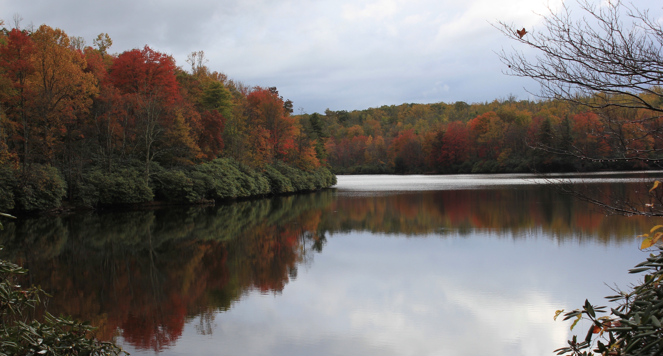
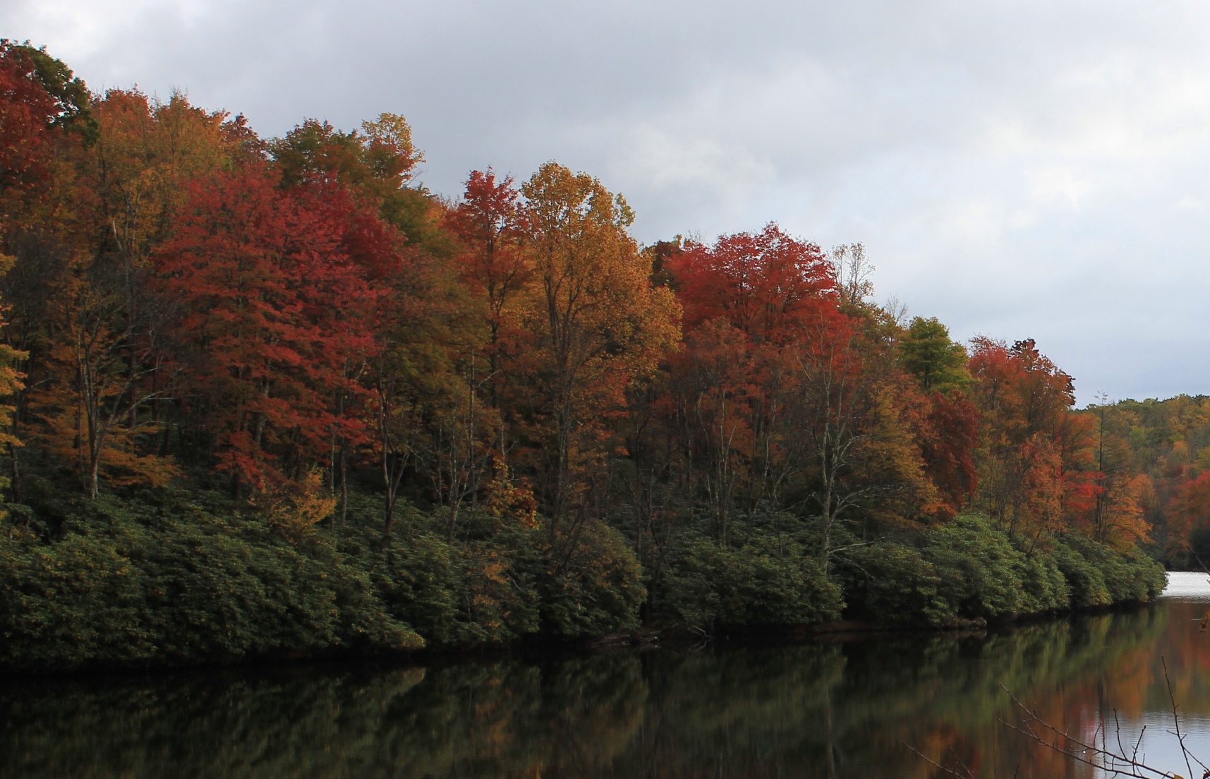
As we drove down the Blue Ridge Parkway towards Blowing Rock, the skies below 4000 feet cleared and created ideal conditions for these photos showing the fall colors and reflections on Julian Price Lake.
Immense ReflectionPerfect SymmetryBlue Sky ReflectionFall Colors Reflect on the LakeRhododendron on the LakeBlue Ridge Mountains – Ramparts of Grandfather MountainJulian Price Lake
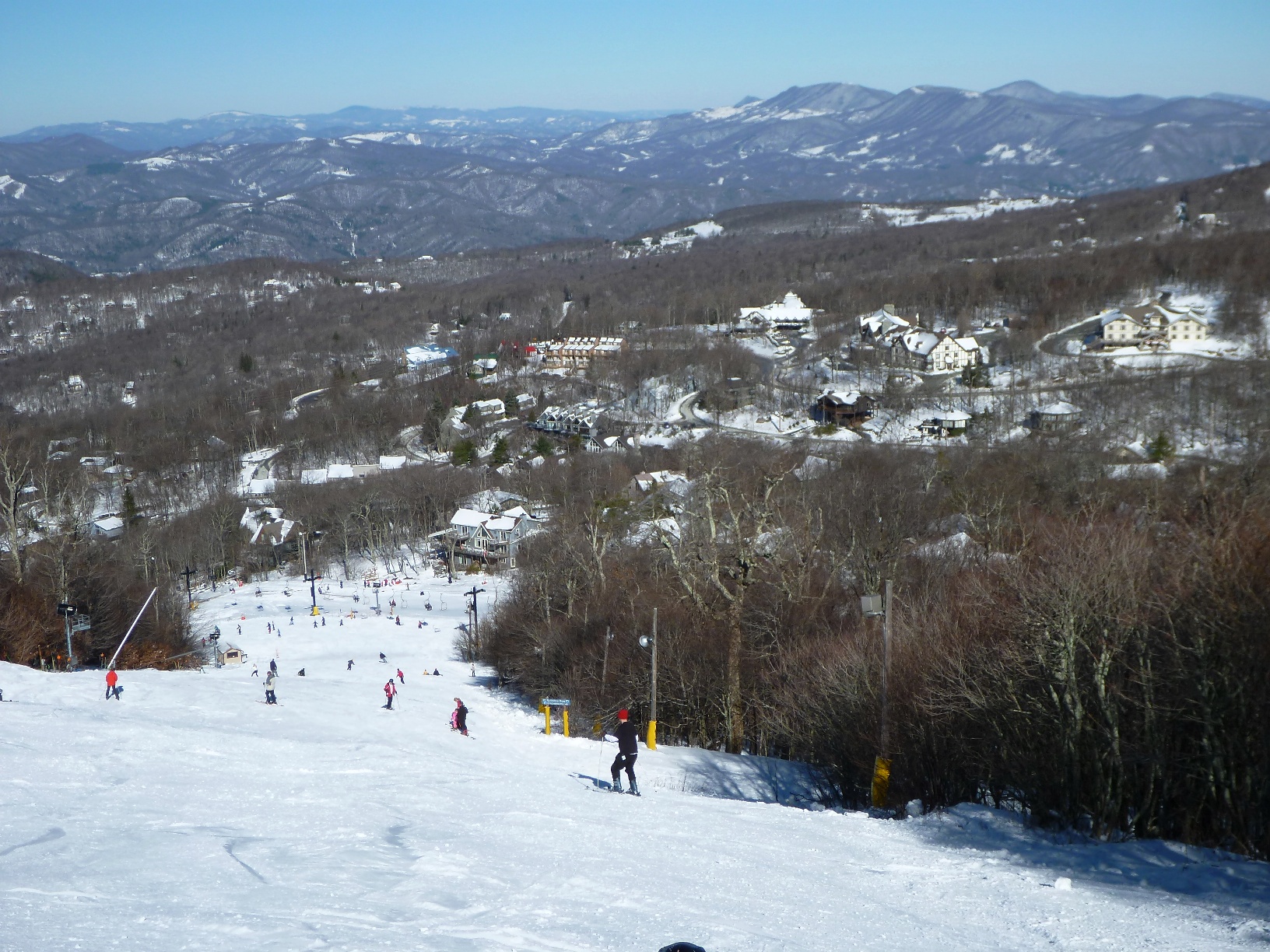
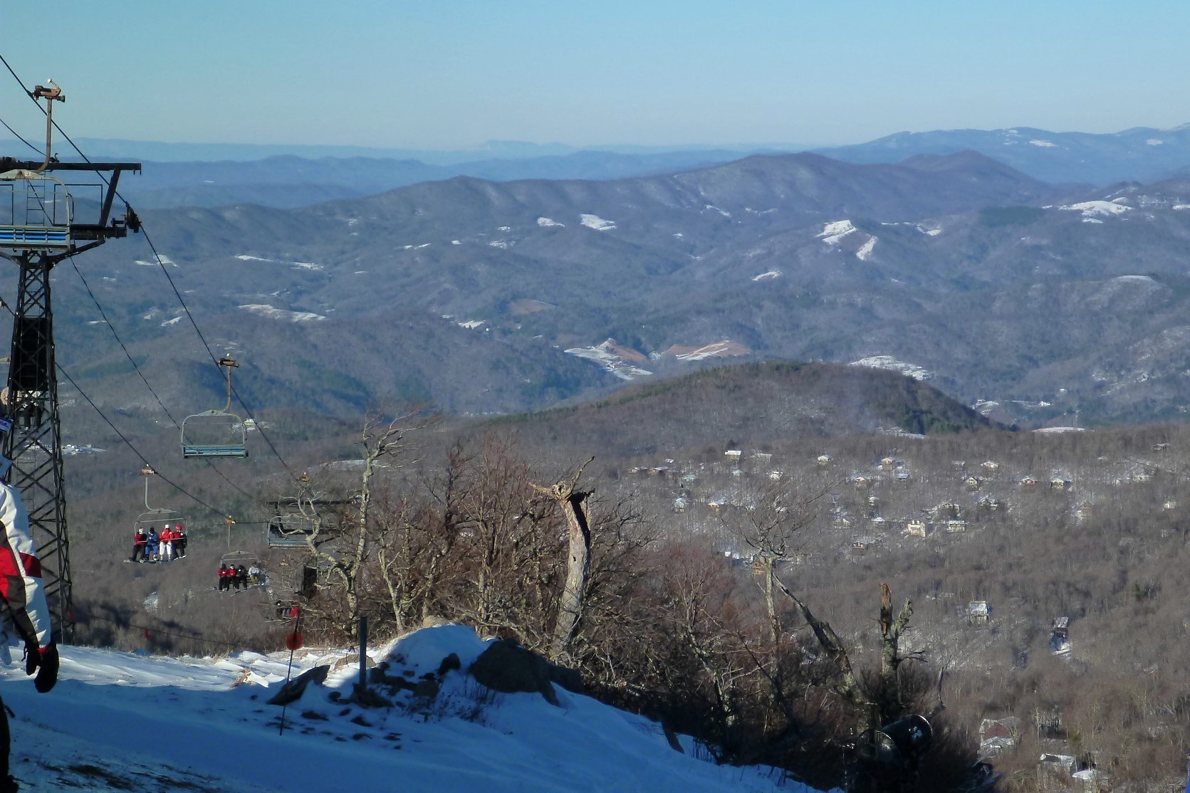
On January 17 and 18, an unusually powerful snowstorm clipped across the Southern Appalachians, dropping over 13″ of fresh snow in the coalfield counties of Southwest Virginia and the high country of North Carolina. On January 18, Beech Mountain ski area reported the highest one-day snowfall of any area in the lower 48 states (for that day).
The following photos are from Beech Mountain on January 19:
Beech Mountain, January 19, 2013
The Alpine-like base area looked like a resort out West:
Fresh Snow Glistening on Rooftops
There was snow as far as could be seen. This is the view looking north into Tennessee and Virginia:
The Footsloggers outdoor store in Boone, NC has a 40′ tall, 4000 square foot climbing tower. My son Isaac, age 9, enjoys climbing. Yesterday he did some climbing at the climbing tower. The tower is operated by Rock Dimensions, a climbing service in Boone.
Second Climb at the Tower
The second climb involved a couple of inverted wall sections, where there were angled overhangs.
Second Climb Inverted Section
The final climb was the most difficult. It required him to reach out and around from a three foot overhang. As this is one of the most difficult climbs there, a small crowd gathered to cheer him on. The video below is about 4 minutes.
The section of the Blue Ridge Parkway that skirts around Grandfather Mountain is most impressive. This is the site of the famous Linn Cove Viaduct, where the Parkway is raised up on pylon-like stilts and skirts around part of the mountain as if suspended in midair. This whole section of road has impressive views of the mountain, and off to the east and southeast, all the way to the Piedmont region.
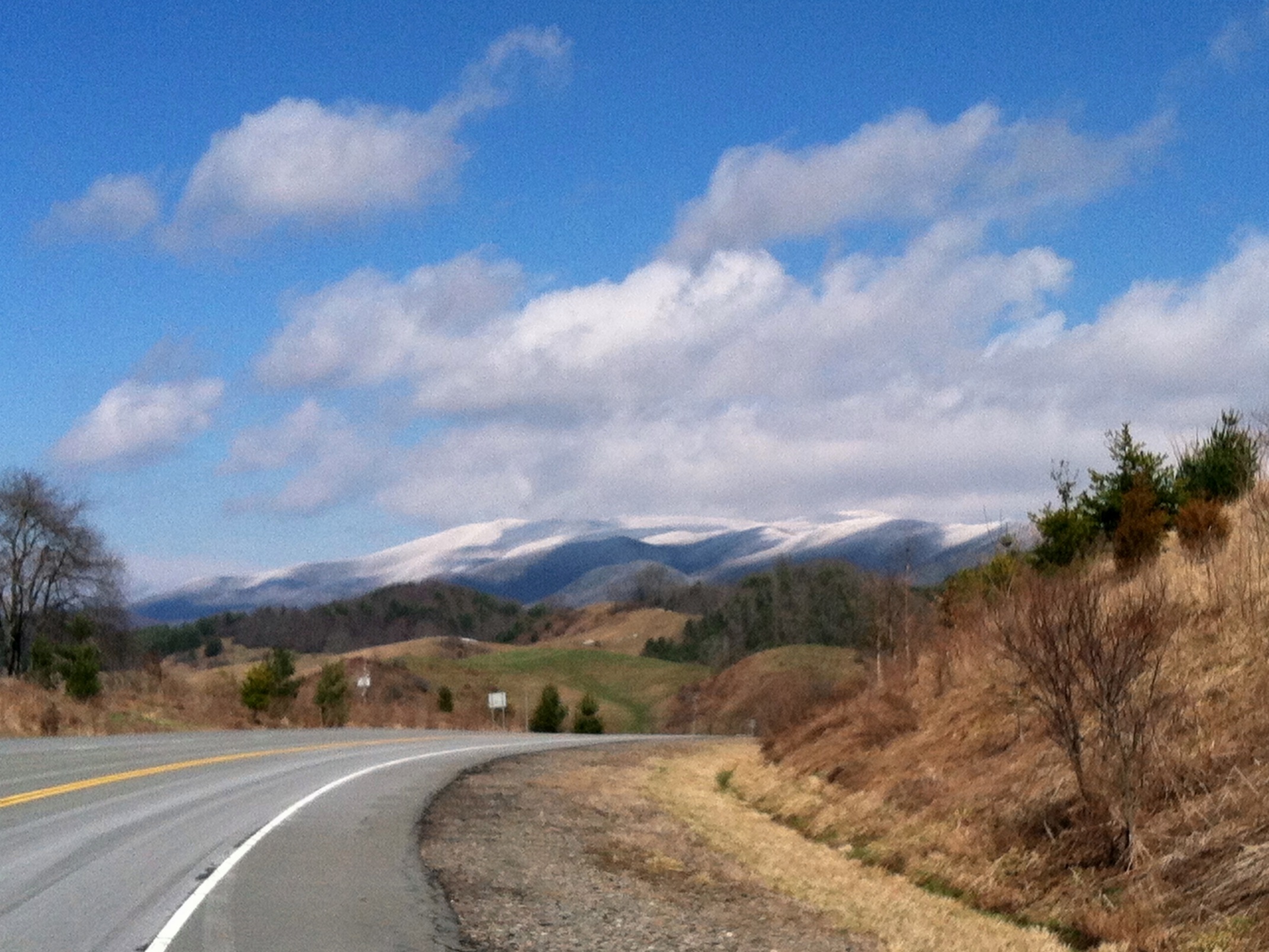
The photo above was taken in March near mile marker 302—right before you begin rounding Grandfather Mountain when approaching from the Blowing Rock Area. Low hanging cumulus clouds accentuate the blueish hue of the mountains. The photo views the mountains and hills to the southeast (Grandfather Mountain is not in the picture but is to the right from this viewpoint, on the other side of the Parkway from this turnoff).
This March we visited Linville Falls, one of the most famous waterfalls in North Carolina, during the 2012 Banff Film Festival in Boone (the inspirational film festival trailer can be seen here). The falls are located just off the Blue Ridge Parkway at mile marker 316. There is a visitor’s center and a short hiking trail (about .8 miles) to the falls.
Water Swirls Around Ancient Stone
The closest viewing area shows the upper falls (not pictured here) in one direction, and beginning part of the lower falls in the other direction. The photos above and below show the beginning part of the lower falls. The lower falls churn through a cavernous semi-circle of eroded limestone, and then plummet about 45 feet into a large pool.
Water Diverted in a Semi-Circle Above Linville Falls
“Chimney Rock Overlook” can be seen from the upper viewing area, as highlighted in the photo to the right. From Chimney Rock Overlook, you can see the lower falls in their entirety, as well as the large cliffs that surround the falls and mark the beginning of the Linville Gorge.
Highlighting the Overlooks Shows the Scale of these Falls
The cliff face next to the lower falls is as impressive as the falls themselves. When we viewed the falls, there was a relatively large volume of water flowing. This caused the falls to jettison outward from the upper pool.
Linville Falls is a very popular stop on the Blue Ridge Parkway (the parking lot at the visitor center is huge), so it is recommended that if you want to visit the falls without hordes of tourists, you should try to see them during less visited times of year such as in spring or winter, or during the middle of the week.
The viewing areas were built in a manner to try to fit into the natural surroundings and are constructed of stone and logs. When they are wet, it is possible they could be treacherous. In particular, the Chimney Rock overlook could be dangerous if someone got too close to the edge of the viewing area, as a fall from that location could be fatal.
The Linville Gorge is one of the deepest gorges in the Eastern United States. I have seen claims that it is in fact the deepest, but there are several others that are comparable (including the Russell Fork Gorge in Southwest Virginia). Suffice it to say that it is deep and impressive. Experienced hikers have become disoriented and lost in this place.
Linville Falls from Chimney Overlook
The Linville Gorge reminded me of the gorge below Abrams Falls close to Abingdon, although without doubt the Linville Gorge is much deeper and longer.
If you find yourself in Boone, Blowing Rock, or on the Blue Ridge Parkway in this neighborhood, a trip to Linville Falls makes for a nice day trip and provides a nice little outdoor experience without too much effort.
Most folks who visit Blowing Rock, North Carolina are on vacation from far away, usually in summer to escape the oppressive heat in places like Florida or maybe Charlotte or Atlanta. Not so for Abingdonians—for us, it’s just hop, skip, and jump over the mountains. It’s exactly 60 miles from Abingdon to Blowing Rock. Perfect for a day trip.
Well Maintained Carriage Paths Encircle Bass Lake, March 2011.
About a mile outside of Blowing Rock, just off Route 220, is the entry to Bass Lake, part of Moses H. Cone Memorial Park. An easy day trip from Abingdon (although certainly meriting a long longer trip if desired), the Moses H. Cone Park is a large, outdoor park managed by the U.S. National Park Service.
Moses H. Cone Mansion, circa 2007
We have been visiting this park for years. One of our spring rituals, when it’s warming up and we are getting cabin fever, is to come over here on a March weekend, before the crowds swarm Blowing Rock.
The walk around Bass Lake, about a mile, is the perfect family walk. There are a multitude of trails lacing the park that go far beyond the lake. A map of the trails, somewhat dated, from the National Park Service is located here.
Mrs. Abingdon Outdoors Revealed: Joanne and Isaac on the porch rail of the Cone mansion, circa 2007. Note the view of the lake in the background.
This is a great place to come to relax—lunch at one of the many restaurants in Blowing Rock and a stroll around the grounds of the estate makes for a nice day.
Aqueduct leading to Bass Lake. Note the mansion at the top of the photo.
Moses H. Cone was a textile magnate that built his country estate in the very early 1900s similar to Vanderbilt’s estate in Asheville. The Cone estate is not quite as exorbitant as The Biltmore, but with 3,500 acres of land and a 13,000 square foot mansion that overlooks the mountains, it’s undeniably grand. The estate was designed with the mansion, which sits at about 4,500′, overlooking the man-made lake and the carriage trails that meander down towards Blowing Rock. More information on the background to the creation of the estate is located here.
The house is open to the public, and is accessed off of mile 295-298 of the Blue Ridge Parkway. While the mansion is worth a visit, what keeps us coming back are the grounds. Imagine Virginia Creeper Trail type trails: well-maintained cinder or pea gravel covered trails.
Future Runner Practicing on the Carriage Path, March 20, 2011
The trails crisscrossing the ground make for an excellent area to train for running. In fact, most times you are here you will see some locals, part-time residents, or visitors running on the carriage trails. Next time you are in the Boone-Blowing Rock area, check out this park. You won’t be disappointed.
Southwest Virginia, Upper East Tennessee, and Western North Carolina have lots of small creeks that are usually more fishable in winter. In winter the water levels may be higher than the summer or fall, there’s no foliage and less brush to block access to the water, and the creeks are no longer clogged with the fallen leaves. It’s a great time of year to hit these creeks, especially during breaks of mild weather.
Wild, Creek-Caught Brown Trout in Smyth County, Virginia, January 2012
You’re not likely to catch lunkers in these waters, but the trout are more likely to be wild and more beautiful than the stockers in the rivers and lakes. They may also be willing to hit dry flies even when there’s no hatch coming off the water. These small creek trout don’t have the luxury of waiting for a full-blown hatch. They’re often stuck within the confines of small pools; this requires them to be particularly opportunistic feeders; and insects on the surface are opportunities to them regardless of season.
There is something especially rewarding about the adventure of hiking where few fishermen have been, where the trout may not have seen men or their fishing gear for a long time before you, and where you have a genuine belief that you are exploring the natural world.
In the Eastern United States, there are not many places that instill these feelings anymore. It has been this way for almost a century:
Most of the truly secret streams were small. The larger streams had names, a public sort of character, commercial importance, perhaps. They were accessible: if they held trout it became known and they were visited regularly throughout the open season. Without restocking they became at last depleted of fish.
But the little back-country feeder brooks were nameless, and inaccessible save by long tramping over the ridges and upland meadows which lay deep beyond the infrequent roads. In such remote rills, known only to ourselves and our most intimate partners, the brook trout swam and lurked to meet his chilly destinies much as he had in the first days of the world. Some of these streams are still where they used to be. . . .
Howard T. Walden, II, Upstream & Down, at 171-72 (First Edition 1938).
In Upstream & Down, Mr. Walden explained that in the East, except for in the “remote semi-wilderness counties,” most small streams were under increasing pressure from development and anglers in the early Twentieth Century. He lamented “the loss of the virgin stream of olden time.”
These days, even in the “remote semi-wilderness counties” of the East (acknowledging that the definition of Eastern “remote semi-wilderness” is probably different today than in the 1930s), there are very few, if any, “nameless” small streams. Nonetheless, the essence of what Mr. Walden wrote back in the 1930s is still true: Remote small streams are still the most likely places to find unspoiled trout waters.
Wild Creek in the Jefferson National Forest, Smyth County, Virginia
In the reality of our increased population and the informational resources of modern times, there is not just a geographical dimension to being adventurous in the outdoors—whether fishing for trout, or otherwise (hiking, backpacking, etc.). There is also a seasonal dimension. Most fishermen hang up their rods and reels come late fall, and many do not take the sport up again until the traditional opening days of April. Thus the ardent angler is far more likely to have a solitary and adventurous experience in winter than in spring, summer, or fall. This is not to say that small creek fishing is not rewarding in the fairer seasons, just to point out the undeniable fact that it is more likely to hold an excitement that comes from undisturbed exploration in the wintertime.
Trouty Water in the Virginia High Country, December 2011
So I will continue to fly fish in wintertime, even if I catch less trout during this season. For while catching trout is the “point of the whole exercise” (as fellow small stream enthusiast and Trout Underground author Tom Chandler has stated), it is not the sole—or perhaps even driving—reason that we engage in this sport.
Exploring Quarrryish Water in Wintertime
P.S. — I will write more about Upstream & Down, a fascinating book, and Mr. Walden’s thoughts about trout fishing in subsequent articles.
The three-mile section of the Appalachian Trail from Route 601 to the top of Whitetop Mountain rewards hikers in all seasons. In the late fall and winter, vistas open through the canopy on the mountainside, and the generally clearer skies provide better long-range views.
Hawthorn Berries Contrast Against an Azure Sky on Whitetop
This is a staple hike for our family; it’s distance is just about right as a challenging, yet quite doable hike for children. (It’s also a great training hike.) In late November, my son Isaac and I did this out-and-back hike up to Buzzard Rocks, the name of the rocky outcroppings at the base of the bald on Whitetop. The majority of this hike is in the deep forest, but in the last 1/4 you leave the larger hardwoods behind, go through some smaller scrub-like trees, and eventually come up onto the large Whitetop bald that is visible from most high points in Abingdon.
The view from the top of Whitetop is one of the best in Virginia. Here is the classic mountaintop shot from our hike:
Vista from Whitetop
During the summer, this hike can be the quintessential AT walk through a “tunnel of trees” until you reach the very top. In winter, however, you can look up and down the mountain at the various boulders and formations, and you can peer deep into the forest. In the photo below, the leafless canopy affords a view of the top part of Grandfather Mountain in North Carolina. During summer you can’t see this until you get to the balds:
Grandfather Mountain View from the Appalachian Trail Between Route 601 and Buzzard Rocks
Here, you can see the treeline giving way to the balds as my son and dog climb the trail. Note also that there was snow on the trail. It is invariably significantly colder up on the balds than below, usually to the tune of about 20° if there is any wind. It is almost as if you break out into the jet stream.
Emerging from the Trees Below
We were treated to a large, migrating flock of goldfinches when we arrived at the bald.
Migrating Flock of Goldfinches on Tall Hawthorn Bushes
The large Hawthorn bushes with their clumps of red berries reminded us that fall was almost over, and the Christmas season fast approaching. Soon similar berries would adorn mantles and wreaths as holiday decorations in people’s homes far below.
Outcroppings near Buzzard Rocks
Hawthorn Bush with Berries Screens View of Iron Mountain and Clinch Mountain
The big-ticket item—the main reason to do this hike—is the fabulous view from the top of Whitetop. The Whitetop bald is one of the largest individual balds in the Appalachian Mountains.
Looking into North Carolina
The vistas are superb from the bald. In the accompanying article, I have put together a panoramic photograph showing how expansive the view is. The photos in this article do not capture how open it is on top of the mountain.
High Altitude Cirrus Clouds Give Way to Long Stratocumulous Cloud on the Horizon
The winds picked up while we were at the summit; I estimated they were in excess of 30 or 35 mph. The ambient air temperature felt like it dropped about 30° from when we were below treeline. We only had on t-shirts, and we began shivering. Fortunately, I had come prepared: Out came the down jackets, the hats and the gloves.
Isaac Thiessen in the Puffy Jacket
It was extremely windy; note in the photo below how the wind has inflated my pants:
Eric Thiessen in the Puffy Vest
The Whitetop hike is not only a fabulous hike; it’s relatively close to home. Coming from Abingdon, you never leave Washington County (except perhaps while on the trail at the summit). At about 23 miles from Abingdon to trailhead, the Route 601-Buzzard Rocks hike is the closest access point to Whitetop and Mount Rogers from Abingdon.
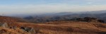
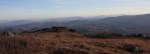
These two panoramic photos taken from a recent trip to Whitetop Mountain show the expansive vista to the southeast at the summit.
If you click on them in an updated browser, they should open in a much larger format that is pretty awesome viewed on 16:9 monitor. There is a slight overlap in the two photographs, but together they form almost a single, panoramic image.
Virginia into North Carolina Panorama
The Blue Ridge in North Carolina Panorama
As I state in the main article, the views at the top of Whitetop certainly justify the climb to the summit.
There is also a gravel road from the east side of Whitetop that goes to the summit of Whitetop. It is Route 89, and it connects to Route 600 near Elk Graden. Route 89 is usually open even in winter, although it is covered in snowpack and requires a 4 x 4.