
After the Storm

This month marks the 75th anniversary of the completion of the Appalachian National Scenic Trail. (To be precise, it was finished on August 14, 1937.) The trail is 2,180 miles long, has over 250 three-sided “shelters,” and links innumerable other trails through 14 states.

For three-quarters of a century people from all over the United States–indeed, from all over the world–have been trekking up and down the Appalachian Trail, or A.T., as most folks in the know refer to it. In commemoration of this milestone, this weekend I hiked a section of the A.T. between Mount Rogers and Whitetop Mountain.

Founded by a small group of hikers, particularly one forester named Benton Mckaye, who envisioned an East Coast “super trail”, the Appalachian Trail Conference started work on the A.T. in the 1920s. By 1930 the trail began to take form as small groups of volunteers worked up and down the mountains of the East. According to the Appalachian Trail Conservancy, this was not a government project but the accomplishment of private, local clubs who mapped and routed sections of the trail, negotiated with private landowners and governmental agencies, and did the physical labor to build it in their respective areas.
To this day, although the A.T. is now owned by the governnment, the Appalachian Trail Conservancy and the many volunteer organizations are critical to the maintenance of the trail.

After World War II, volunteers renewed development of the A.T. In 1948, Earl V. Shaffer, an Army veteran who served in the Pacific Theater, completed the first “thru hike,” or continuous hike of the entire A.T., reportedly in order to “walk off” the stress of the war. In the years since, the A.T. has become a cultural phenomenon in addition to being an outdoor experience. Every year hundreds of individuals from all walks of life attempt to thru hike or section hike part of the A.T., seeking solace, self-exploration, or temporary escape from urbanity on the trail.

In 1968, the United States Congress passed the National Trails System Act, and the A.T. was the first completed national trail designated a National Scenic Trail. This added the A.T. to the system of national parks. The A.T. links two national parks (the Great Smoky Mountain National Park and Shenandoah National Park), and includes Abingdon Outdoors’ own Mount Rogers National Recreation Area. While the A.T. has always crossed the MRNA, the trail used to traverse the Iron Mountains to the north of Mount Rogers and Whitetop Mountain. It was re-routed over Mount Rogers and Whitetop due to scenic beauty of these highest mountains in Virginia. The old shelters on Iron Mountain are still maintained as part of the Iron Mountain Trail.

Most folks—like myself—have no intention (at least no immediate intention) of hiking the entire length of the A.T. Most folks hike part of the trail in a day, or at most over the course of a weekend or for a week or two. The trail is also frequently utilized by the Boy Scouts and by church and civic groups for hiking and camping trips.

The trail is designed not to be easy: It randomly meanders and seldom takes the easiest path from point “A” to point “B”. At points it certainly appears as if the A.T.’s designers purposely placed obstacles such as rocks and roots in the way. This keeps the trail challenging.

The A.T. is different things for different people: A place for solitude and meditation; a place for a communal outdoor experience; a training ground for other pursuits; a naturalist’s place to study flora and fauna. Perhaps Benton MacKaye best answered the question, “What’s the ultimate purpose of the Appalachian Trail?”
He said, “To walk. To see. And to see what you see.”
Happy Birthday, A.T. . . . See you on the trail.

The last two days have seen record-breaking hot temperatures across the Eastern United States, including in Southwest Virginia. Yesterday it was 103 in Kingsport and 101 in Bristol, breaking the record high temperature ever recorded in the month of June in our region. Abingdon was 100, the highest temperature here in any month in 25 years.

It’s way too hot, especially for those of us in the mountains. I’m pining for cooler weather−way cooler weather. Along those lines, the B&W photo I took above shows massive hoarfrost on one of the solitary trees up on Whitetop in 2010, the last real winter we have had in Southwest Virginia.
Just looking at that photo cools you off a little bit, doesn’t it? Wish I was high up on a mountain with snow right now.
Here is a photo identifying the major peaks visible from Buzzard Rocks, the outcroppings about 200 vertical feet below the summit of Whitetop Mountain. Buzzard Rocks provides one of the best vistas towards Southwest Virginia, looking back into both Virginia and Tennessee. The small communities of Whitetop and Green Cove can be seen in the foreground.

Buzzard Rocks can be accessed via the gravel road 89 from State Route 600 near Elk Garden, via the Appalachian Trail from Elk Garden from State Route 600, or via the climb from State Route 601.
The pointy mountain labeled 3700′ is Fodderstack Mountain. This is a promentory that divides the valley towards Laurel Bloomery in Tennessee. Tennessee Laurel Creek runs down this valley between Fodderstack and the Iron Mountains towards Damascus.
Between the Iron Mountains and Holston Mountain lies Shady Valley, Tennessee. Beaverdam Creek runs down this valley from Shady Valley towards Damascus. On the other side of Holston Mountain is South Holston Lake, the TVA impoundement that is the largest lake in region.
Between Holston Mountain and Clinch Mountain (which is barely visible on the far horizon) is the great valley that encompasses most of Washington County, Virginia, including Abingdon.
For a comparison, here is another view in the evening from the same vantage point, slightly below Buzzard Rocks.

Whitetop Mountain contrasts with the almost-full foliage on the hillsides of Abingdon yesterday afternoon.


The three-mile section of the Appalachian Trail from Route 601 to the top of Whitetop Mountain rewards hikers in all seasons. In the late fall and winter, vistas open through the canopy on the mountainside, and the generally clearer skies provide better long-range views.


The large Hawthorn bushes with their clumps of red berries reminded us that fall was almost over, and the Christmas season fast approaching. Soon similar berries would adorn mantles and wreaths as holiday decorations in people’s homes far below.


The Whitetop hike is not only a fabulous hike; it’s relatively close to home. Coming from Abingdon, you never leave Washington County (except perhaps while on the trail at the summit). At about 23 miles from Abingdon to trailhead, the Route 601-Buzzard Rocks hike is the closest access point to Whitetop and Mount Rogers from Abingdon.
These two panoramic photos taken from a recent trip to Whitetop Mountain show the expansive vista to the southeast at the summit.
If you click on them in an updated browser, they should open in a much larger format that is pretty awesome viewed on 16:9 monitor. There is a slight overlap in the two photographs, but together they form almost a single, panoramic image.
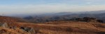
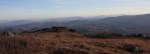
As I state in the main article, the views at the top of Whitetop certainly justify the climb to the summit.
There is also a gravel road from the east side of Whitetop that goes to the summit of Whitetop. It is Route 89, and it connects to Route 600 near Elk Graden. Route 89 is usually open even in winter, although it is covered in snowpack and requires a 4 x 4.
Yesterday morning, November 17, we had the first snowfall in Abingdon. It started after I was already at work, so I didn’t get any pictures of it. It only snowed for a couple of hours; it was not a particularly heavy snow, and the ground was too warm for any of it to accumulate.
Unlike many folks, I always enjoy the first snowfall in town, as it means we’re in the season where we’ll see more of it in the mountains as winter approaches.

However, the snow yesterday wasn’t the first this fall in Southwest Virginia. In the eastern end of Washington County we had noticeable accumlation twice in October.
The first heavy dusting occurred on Saturday, October 1, 2011. When we were camping at Grindstone last month (see my previous article), the campground host told me that it snowed all Saturday that first weekend of October, and there was significant accumulation all over the north side of Mount Rogers.

By the time I took the photo above, the weekend storm cleared out, the sun warmed the day back into the upper 50s°, and most of the snow had melted off of the mountains. You can still see some remnants on the summit of Mount Rogers (on the left side of the photo). The scene earlier in the day was more dramatic; it is a strange contrast to see snow on the mountains behind the green, deciduous trees in the valley before they’ve changed into their fall colors.

On the evening of September 21, 2011, a series of beautiful rainbows appeared over the mountains. From Abingdon, they appeared to rise from behind Holston Mountain and Whitetop Mountain. I took some quick photos of them. Somewhere 15,000′ or more above sea level in the sky, my friend took a photo of the same rainbows. I thought it was unique to have these two different perspectives, thus this post. Compare the photo on the right with the photos below. It’s amazing that no matter where you were, the rainbows appeared to rise to the heavens.


