This was a good year for viewing the fall foliage in Southern Appalachia. Here are some photos from the Buller Fish Hatchery in Smyth County, Virginia in early October.


This was a good year for viewing the fall foliage in Southern Appalachia. Here are some photos from the Buller Fish Hatchery in Smyth County, Virginia in early October.
This past Sunday afternoon my sons Isaac, Karl and I went for a five mile loop hike on the Iron Mountain Trail / Forest Road 84 off of State Route 600 in Smyth County. These photos were taken at the Skulls Gap scenic parking lot, which is about 3500′. The colors are starting to change at higher elevations and all foliage is taking on that golden hue in the evening that signals autumn has arrived. Click on any of the photos to enlarge to appreciate the panoramic views.


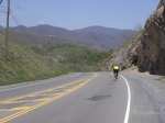
Driving south along I-81 in Wythe County, you cannot help but notice that there is one aesthetically appealing mountain on your left that notably rises from the valley floor much closer to the interstate than the surrounding mountains. This is Glade Mountain.

The mountain becomes visible to the south of the interstate just past Rural Retreat (Exit 60). Glade Mountain parallels the interstate for almost 10 miles, receding only as you approach Atkins (Exit 50).
Glade Mountain is part of the Mount Rogers National Recreation Area and lies entirely in the Jefferson National Forest. It is distinctive in that it is separated from the main part of the recreation area, yet is one of the largest mountains in terms of mass within the area. Despite its proximity to I-81, it is seldom visited other than by local Wythe and Smyth County residents and Appalachian Trail thru-hikers. Thru-hikers get their first view of Virginia’s valley and ridge mountains when they cross the mountain. Glade Mountain affords views of Big Walker Mountain, Clinch Mountain, and even part of East River Mountain (the West Virginia state line) to the north.
Most out-of-the-area hikers pass up Glade Mountain for other more written about and better known mountains further down the interstate. This leaves Glade Mountain to those of us who appreciate its solitude. I have hiked this mountain on several Saturday afternoons, and the only other hikers I have ever met on the mountain are a handful of thru-hikers in spring and early summer on their way north. I also once met a single thru-hiker on his way south in the fall.
The AT crosses Glade Mountain on a north-south axis. The base of the trail leaves the Settlers Museum of Southwest Virginia in Groseclose, and after about ½ mile through the forest heads up the mountain in a due south direction. Once climbing the mountain, the trail parallels a very small creek (about 1-2 feet in width). In June the mountain laurel on the north side of the mountain bloom profusely.

The northern section of the trail (the side closest to the Settlers Museum) has huge rhododendron thickets and mountain laurel thickets. At some points you travel through a tunnel of rhododendron that barely allows room for a backpack.

The trail travels uphill for about 3 or 4 miles, crossing Forest Road 86 (identified on some maps as Forest Road 644). The trail continues south and higher up the mountain to the Louise Chatfield Shelter, a fairly nice shelter on the mountainside close to a year-round creek.

The trail then continues for another approximately 1 ½ to 2 miles to the top of the mountain. There are a few places on the trail where the trees open up enough for a brief view of the valley and to the north. The views are much better in winter, when the canopy does not obscure the view. Towards the summit there are expanses of ferns over four feet in height under the trees. There is no designated spot or clearing that identifies the location of the summit.

The trail then descends the south side of the mountain until it crosses Forest Road 86 again, eventually crossing Route 16 approximately 4 miles further.
Forest Road 86 forms a band around the entire mountain about ½ way up from the base. Forest Road 86 is open to mountain bikes (and even off-road vehicles), and can be combined with the AT to form a large loop run (approximately 12 miles).

Access to the trailhead of this mountain is easy. Simply take Exit 54 off of I-81 and follow the signs to the Settlers Museum. The trailhead is about 6 miles from the interstate. More detailed directions are here:
From I-81 South (follow signs to the Museum):
1. At bottom of exit ramp at Exit 54 on I-81, turn left
2. Continue about 0.1 mile to Rt 11
3. Turn left on Rt 11, travel 1.3 miles to Rt 679
4. Turn right on Rt 679, travel 0.8 mile to Rocky Hollow Road
5. Turn right on Rocky Hollow Road, continue 1.2 miles to Museum
6. The Settlers Museum is on your left.
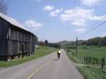
This is the second installment in a series on cycling routes near Abingdon. The “Saltville Loop” is one of the more often ridden, middle-length cycling loops in Abingdon and Washington County. It is popular because the roads are relatively low in traffic (especially the backside of this loop) and have only a few moderate climbs. Below is a further description and directions for the ride. Click on any of these thumbnail photos to expand them.
Distance: Approximately 46 miles
Time: Approximately 3 hours @ about 15 mph
Difficulty Notes: Some moderate climbing on hills; big rollers, especially on the middle section of the first half of this route
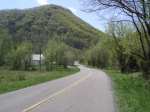
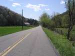
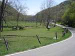
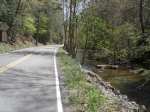
The Saltville Loop is one of the major training routes used by the local cyclists in Abindgon. The route generally follows the valleys between Abingdon and Saltville, which is in Smyth County. Because the route generally follows the valleys, there is only one sustained climb, which is on Route 80 from the intersection with the North Fork of the Holston River back up to Old Saltworks Road.
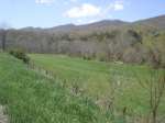
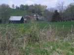
There are some beautiful farms on Old Saltworks Road. After about 8 miles into this ride, the hill that parallels Old Saltworks Road on your right (immediately to the south of the road) that gets higher and higher is the beginning of Big Walker Mountain. Further to the east, towards Marion, Big Walker Mountain rises to almost 3500′ above sea level.
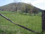
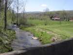
Poor Valley Road on the way back from Saltville provides excellent views of Clinch Mountain. Coming from Saltville, after about 5 miles on Poor Valley Road you will pass Big Tumbling Creek and the Clinch Mountain Wildlife Management Area, one of the largest wildlife management areas in the Commonwealth of Virginia with over 30,000 acres.
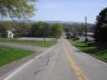
This route starts in downtown Abingdon at the Jockey Lot of the county courthouse or as an alternative may start at the Coomes Center.
There are several alternative ways to come back from Hayters Gap. The main cycling roads between Abingdon and Saltville, Old Saltworks Road and Poor Valley Road, are described here. These roads combined with the other connector roads described herein make for a good approximate 46 mile training ride.
Another alternative route is to do the whole route in reverse, i.e., in a clockwise fashion taking the route from Abingdon to Saltville via Poor Valley Road first and then coming back to Abingdon via Old Saltworks Road. Coming back from Saltville, a good alternative to hilly Old Saltworks Road is to leave Saltville and take Old Saltworks Road until the junction with Old Mill Road, aka County Road 750. Turn left onto Old Mill Road. Old Mill Road will take you all the way to the Town of Glade Spring, where it junctions with Hillman Highway, aka County Road 609. Turn right on Hillman Highway, and it will take you back to Main Street in Abingdon. This is a fast route. Note that Hillman Highway can have higher traffic than the other route described above.
