All posts by Eric Thiessen

Footbridge over Straight Branch

This is the Appalachian Trail footbridge that crosses Straight Branch Creek near Damascus, Virginia.  This photograph was taken on Saturday, July 9, 2011.  If you click on the photo and enlarge it, you can see the white blaze on the anchor tree on left of the footbridge in the background.  In order to obtain this composition, I waded into the center of the creek and set up a tripod.  I slowed the shutter speed slightly in order to capture the movement of the water in the foreground.

Tour de Rocky Top: A Twisty, Thirst-Quenching Metric Century

The Tour de Rocky Top is a metric century ride in Knoxville, Tennessee organized by Race Day Events, a private race organization.  This ride is unique in this region in that it starts and finishes at a large pub, Barleys Tap Room.

I did this metric century on Saturday, July 2, 2011.  The ride went through downtown, across the Tennessee River, and out into the country to the south and east of Knoxville towards the Smoky Mountains.  The ride never got into the mountains, but had many rollers, totaling about 3,000′ in total elevation in climbing (and descending) in the 62 mile course.   There were three well-stocked aid stations on the ride.

The staging area for this ride was excellent.  It began right next to Barleys Tap Room.  Adjacent to the tap room is a six lane off-ramp/overpass.  The City of Knoxville has turned the area under the overpass into a very large parking lot.  This was a perfect area to park and leave vehicles in the shade while cycling.  The ride started cool but became quite hot.  Who would have thought riding in Knoxville in July under a noon sun could get hot?  On the negative side, there was no place to shower at the end of the ride.  You pretty much had to just change into street clothes next to your car or go into Barleys and use the restroom to do so.

This is definitely more of true “tour” than a race.  While there may have been a lead group pushing the pace at the front (I don’t know if there was or not since I was at the back side of the starting line), there were about 45 turns on the course.  Every time you got up to speed or began to proceed in a good rhythm it seemed like there was a turn.  And many of these turns were not your gradual “bear to the right or left” turns, but true 45 degree turns on small country roads, several at stop signs.  So this ride was not conducive to a personal best time record, but it was nonetheless a pleasant tour of the countryside around Knoxville.  The race organizers did a good job of getting the riders out of and back into the downtown area on roads with relatively slight traffic, which was impressive.

I finished the ride in approximately 4 hours.  Actual riding time was about 3 hours, 40 minutes.  The average speed on my odometer was 16.2 mph.

The ride ended on a great note.  The ride ended at Barleys Tap Room, a restaurant with excellent pizza in the old town section of Knoxville.    The Barleys in Knoxville is an open, unfinished warehouse with brick interior walls, large rough-hewn beams, and a nice garden patio.  Barleys had two large flat screen TVs showing coverage of the first day of the Tour de France.  Watching part of “the” Tour with several hundred fellow cyclists after doing a century ride was a nice way to start off the Independence Day weekend.

A note on getting to the ride:  The venue is about 1 hour, 50 minutes from Abingdon.  It is a straight shot down I-81.  It makes for an early morning to do the trip in one day.  There are several nice hotels in downtown Knoxville close to the race staging area, and there are lots of restaurants and boutique stores in this area of Knoxville.  Going down the evening before would probably not be a bad idea.

Big Walker Mountain and the 2011 Big Walker Mountain Century Ride

Big Walker Mountain is one of the most prominent mountains in Southwestern Virginia’s valley and ridge province.  From its rise as mere hill in Washington County (see my description of it in the Saltville Loop article), Big Walker rises to 3500’ above sea level,  and all the way from Saltville to the New River beyond Pulaski it is the main dividing ridge between the great valley that contains Route 11 and Interstate 81 and the valleys to the north.  In fact, it is so prominent and without any significant gap that the engineers who built I-77 created a tunnel to go through it.

The Southwest Virginia Cyclists use the primary and secondary highways that cross Big Walker Mountain for many of their training climbs.  They also sponsor two organized rides over the mountain each year, the Mother of a Metric and the Big Walker Mountain Century Ride

The Ride

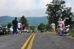
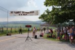
This past weekend, Saturday, June 18, 2011, was the 8th Big Walker Century Ride.  The Big Walker Century has four ride options, including a metric century (100 kilometers) and an English century (100 miles).   This was the second year I did the metric century with a buddy from Abingdon.  There were about 100 riders who toed the start line in the morning.

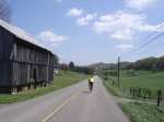
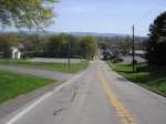
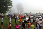
The conditions turned out to be good for a long distance ride.  The morning started out cloudy, a bit chilly, and threatening rain.  As the ride progressed the skies cleared somewhat, and we had partly sunny weather for the tail end of the ride.  The ride starts and finishes in Wytheville.  The beginning of the ride this year began with a typical peloton mass start in downtown Wytheville at 7:30 AM.  There was a police escort for at least the first 15 miles.  This ride usually starts out at a pretty hard pace.  The local pack of Southwest Virginia Cyclists leads the peloton, and they are usually hammering pretty hard following the police car.  This year there were about 100 cyclists in the peloton.

This year involved an inauspicious start as I was cut off in the peloton by an errant rider within the first five miles.  I was driven off the pavement.  Like the famous decision of Lance Armstrong to take a short cut in stage 9 of the Tour de France in 2003 in order to avoid the crash with Joseba Beloki, or the quick decision of many professional riders to go off the pavé in Paris Roubaix to avoid crashes, I had to make a split second decision to avoid a crash and went off Route 11 at 30 mph.  I drove into the gravel shoulder and feathered my brakes to slow, standing on the pedals and leaning back so as not to endo.

While I was fortunate the incident occurred where there was a shoulder that allowed me to decelerate without flipping or crashing, I was unfortunate in that it occurred on a stretch of road just before the beginning of a long hill.  With adrenaline pumping and my heart pounding, I came to a stop, looked up, and saw the back peloton receding towards the distant top of the hill.  Having lost contact with the peloton and with no forward momentum, I then realized I would have no draft for next 15 or so miles to the base of the climb; the lead pack was gone, not be seen again for the rest of the ride.  I eventually caught up with my buddy James, and we rode the rest of the ride more or less together.

The Climbs

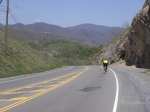
The climb up Big Walker Mountain on Rt. 52 is a moderately difficult climb of 1000 vertical feet at a 5% gradient (from 2400’ to 3400’).  The climb takes 30-45 minutes.  The gradient is consistent—there are no very sharp spikes in the gradient, thus allowing a cyclist to get into a good rhythm.

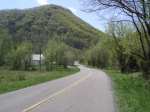
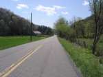
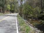
Coming from Wytheville, when you reach the top of the mountain on the metric century ride you go left (west) down Old Mountain Road, aka County Road 621, which is a narrow single lane road with great views down the valley.  County Road 621 actually resembles many of the mountain roads in Europe with its solid white lines on both sides and proximity to the side of the mountain, sometimes without any guard rail to prevent going off the side.  (Last year the organized ride went right at the top of the mountain continued down Route 52.) 

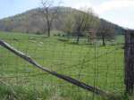
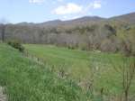
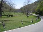
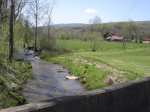
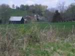
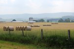
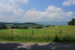
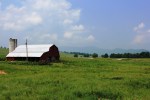
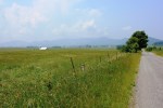
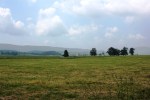
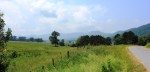
The most scenic part of the ride is definitely on the north side of the mountain in Rich Valley.   The valley is fairly narrow with mountain scenery on both sides.

The climb up the backside (north side) of the mountain on Route 52 is about 700 vertical feet at a 5.2% gradient (from 2700’ to 3400’).  The gradient on this climb is also consistent.  This is just a bit steeper climb with tighter switchbacks than the climb up the south side.

We finished the ride in 3 hours, fifty minutes at an average speed of 16.4 mph.  We also spent about 20 minutes out on the course stopped at aid stations; they were well-stocked and had lots of goodies for re-fueling.

Training on Big Walker

I have done the Big Walker Mountain climb many times on my own without any organized ride.  This is one of the best training rides in Southwest Virginia.  Route 52 has a good, steady gradient and is generally wide for a mountain road in this region. The climb is similar to the climb over Route 421 near South Holston Lake in Bristol, Tennessee.

One way to approach this climb without riding on Route 11 (the busiest stretch of the organized century ride) is to start in Rural Retreat, Virginia (Rural Retreat is ½ mile to the south of Exit 60 on I-81).  Park in one of the municipal parking areas or church parking lots in downtown Rural Retreat. 

From your starting location, take Main Street north back towards the Interstate.  You ride under the I-81 at Exit 60 and will be on Black Lick Road, aka County Road 680.  Continue north on Black Lick Road.  Black Lick Road eventually junctions with Route 52.  Make a left on Route 52 and you will approach the Big Walker Climb.  Once you reach the top of the mountain you can go down the backside, or simply return back to Rural Retreat.  From this point you can follow the directions from the cue sheet from the organized ride, which is set forth below.

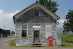
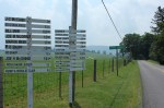
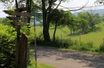
At the top of the mountain there is the Big Walker Country Store.  This is good place to refuel.  There is also a lookout on the north side of the mountain and some scenic vistas from the store itself.

Cue Sheet for Big Walker Mountain Metric Century Ride

Start                      Head southwest on S Main St toward N 4th St 

0.43mi                  Turn right onto N 12th St 

0.43mi                  Head northwest on US-11 S/N 12th St toward W Monroe St Continue to follow US-11 S

1.1mi                     Slight left onto US-11 N/W Lee Hwy 

13.19mi                Turn right onto Kimberlin Rd/State Route 682 

13.2mi                  Head north on Kimberlin Rd/State Route 682 toward Mt Airy Rd/State Route F-015 

14.2mi                  Head northeast on Kimberlin Rd/State Route 682 toward Ridge Top Dr

Continue to follow Kimberlin Rd

16.41mi                Turn left onto Blacklick Rd/State Route 680 

16.42mi                Head north on Blacklick Rd/State Route 680 

18.53mi                Turn left to stay on Blacklick Rd/State Route 680 

19.18mi                Turn left to stay on Blacklick Rd/State Route 680

Continue to follow State Route 680

23.51mi                Turn left onto U.S. 52 N/Stony Fork Rd (Note this is the junction I describe in the alternative trip from Rural Retreat)

23.52mi                Head northwest on U.S. 52 N/Stony Fork Rd

Continue to follow U.S. 52 N

30.81mi                Head southeast on U.S. 52 S/S Scenic Hwy W toward Old Mountain Rd/State Route 621 

30.82mi                Turn left onto Old Mountain Rd/State Route 621 

33.66mi                Head west on Old Mountain Rd/State Route 621 toward VA-42 E/W Blue Grass Trail 

33.76mi                Sharp right onto VA-42 E/W Blue Grass Trail 

38.69mi                Head east on VA-42 E/W Blue Grass Trail toward U.S. 52 S/S Scenic Hwy 

38.7mi                  Turn right onto U.S. 52 S/S Scenic Hwy 

39.41mi                Turn left onto State Route 617/Waddletown Rd 

39.42mi                Head west on State Route 617/Waddletown Rd toward U.S. 52 N/S Scenic Hwy 

39.43mi                Turn left onto U.S. 52 S/S Scenic Hwy

Continue to follow U.S. 52 S

42.87mi                Head east on U.S. 52 S/Stony Fork Rd

Continue to follow U.S. 52 S  (Note that if you are going back to Rural Retreat, you need to watch for Black Lick Road, aka County Road 680, after coming off of the mountain, you would make a right onto Black Lick Road and follow it back into Rural Retreat)

53.04mi                Head east on N 4th St toward W Ridge Rd 

53.04mi                Turn right onto W Ridge Rd 

53.92mi                Head southeast on W Ridge Rd toward N Petunia Rd 

55.97mi                Turn left onto N 4th St 

55.97mi                Head southeast on N 4th St toward W Ridge Rd 

55.98mi                Turn left onto W Ridge Rd 

56.09mi                Head northeast on W Ridge Rd toward Tazewell St 

56.1mi                  Turn right onto Tazewell St 

56.44mi                Turn right onto W Spiller St 

56.44mi                Head southwest on W Spiller St toward N 4th St (you are in downtown Wytheville)

New Alvarado Station

Tommorrow the Town of Abingdon will officially open the new Alvarado Station on the Virginia Creeper Trail during a ceremony at the site of its construction.  Earlier this week I drove out to Alvarado for an evening run and an inspection of the new facility.  Painted white with green trim, the new Alvarado Station matches the design and colors of the restored train stations further up the trail at Green Cove and at Whitetop.

Approaching Alvarado Station from Abingdon on the VCT

The new Alvarado Station has restrooms and has a nice parking lot that will accommodate more vehicles at this area of the trail.  The additional parking at this section of the trail will hopefully take some pressure off the parking areas at Watauga Road and in Abingdon on busy weekends.

Over the years Alvarado has become a more interesting spot on the trail.  The Abingdon Vineyard and Winery, a small winery across the South Fork of the Holston River, is a day-trip destination in and of itself.  While personally I am usually too engaged in exercise on the trail to stop for a glass of wine, it would be a pleasant break if you were taking a more leisurely ride on the trail.  The winery is located less than a half-mile down the road from the Virginia Creeper Trail.  You could easily ride your bike there from the trail.  The wine tasting room is at the junction of a small creek and the South Fork of the Holston River.

There is also a small store/restaurant called the Old Avarado Station that is right next to the Town-owned, new facility.  The store has cold drinks, snacks, baked goods, and barbecue.  The location of this store is the “last stop” when you are travelling from Damascus to Abingdon on the trail, or is the first stop on the way from Abingdon to Damascus that has food or drinks. 

Directions

Alvarado Station with Parking Lot

For those unfamiliar with the area, Alvarado is a locality on the Virginia Creeper Trail about 8 miles from Abingdon and 5 miles from Damascus.  By car it is reached by taking Route 58 east in the direction of Damascus. 

About 6 miles from Abingdon, turn right on Osceola Road, aka County Road 722.  After a mile or two Osceola Road turns into Alvarado Road, aka County Road 710, which crosses the North Fork of the Holston River.  About 100 yards past the bridge there is the parking lot and new Alvarado Station.

Saltville Loop

This is the second installment in a series on cycling routes near Abingdon.  The “Saltville Loop” is one of the more often ridden, middle-length cycling loops in Abingdon and Washington County.  It is popular because the roads are relatively low in traffic (especially the backside of this loop) and have only a few moderate climbs.  Below is a further description and directions for the ride.  Click on any of these thumbnail photos to expand them.

Distance:  Approximately 46 miles

Time:  Approximately 3 hours @ about 15 mph

Difficulty Notes:  Some moderate climbing on hills; big rollers, especially on the middle section of the first half of this route

The Saltville Loop is one of the major training routes used by the local cyclists in Abindgon.  The route generally follows the valleys between Abingdon and Saltville, which is in Smyth County.   Because the route generally follows the valleys, there is only one sustained climb, which is on Route 80 from the intersection with the North Fork of the Holston River back up to Old Saltworks Road.

There are some beautiful farms on Old Saltworks Road.  After about 8 miles into this ride, the hill that parallels Old Saltworks Road on your right (immediately to the south of the road) that gets higher and higher is the beginning of Big Walker Mountain.  Further to the east, towards Marion, Big Walker Mountain rises to almost 3500′ above sea level.

Poor Valley Road on the way back from Saltville provides excellent views of Clinch Mountain.  Coming from Saltville, after about 5 miles on Poor Valley Road you will pass Big Tumbling Creek and the Clinch Mountain Wildlife Management Area, one of the largest wildlife management areas in the Commonwealth of Virginia with over 30,000 acres.

This route starts in downtown Abingdon at the Jockey Lot of the county courthouse or as an alternative may start at the Coomes Center. 

Directions

  1. From downtown, travel on Valley Street east until it turns into Walden Road.  From the Coomes Center, make a right out of the Coomes Center and travel down to Walden Road.  Make a right on Walden Road. 
  2. Travel on Walden Road until you intersect with Old Saltworks Road (also known as County Road 740).  Turn left onto Old Saltworks Road.
  3. Travel on Old Saltworks Road until you reach the T-bone junction with Route 80.  Turn left here onto Route 80.
  4. Travel for about 1 mile.  You will approach an area of open fields.  The road makes a fairly sharp left turn at this point.  About 100 yards past this point there is a junction with Old Saltworks Road, aka County Road 745.  There is a sign for Saltville.  Turn right here to stay on Old Saltworks Road, aka 745.
  5. This road travels through the community of Clinchburg, and then continues into Saltville.  There is another junction with Route 91.  Turn left onto Route 91 which goes into Saltville.  This is about a 20 mile ride at this point.  Saltville is a good place to take a rest break and refuel if necessary at one of the gas stations with some water or sports drinks.
  6. Route 91 is Main Street.  One of the first roads as you enter into Saltville is Bank Street.  Make a left onto Bank Street.
  7. Bank Street turns into Allison Gap Road.  Continue on Allison Gap Road, aka County Road 634, as it leaves town.  Allison Gap Road eventually makes a junction with Poor Valley Road.  Veer to the left and stay on Poor Valley Road, aka County Road 613.  Poor Valley Road is a long, generally flat road that parallels the base of Clinch Mountain for about 10 miles. 
  8. Poor Valley Road eventually junctions with Hayters Gap Road, aka Route 80.  Stay to the left on Route 80 which continues parallel to Clinch Mountain (a right here would take you up the south side of Clinch Mountain, one of the largest climbs in Washington County and the subject of a future article).
  9. Route 80 will take you through the community of Hayters Gap—just a church, schoolhouse, and a few homes), and then goes downhill and follows Wolf Creek until you intersect with the North Fork Holston River.
  10. Stay on Route 80.  At this point the road turns up for the only lengthy climb, about 2 miles at a consistent 4-6% gradient, until it tops out in the community of Lindell.  This is the main climb on this ride.
  11. Stay on Route 80 as it continues through the large area of open fields you passed on the way out.  You will pass the junction for County Road 745 on the way out; however, stay on Route 80.  From this point, you now simply retrace your route back to Abingdon. 
  12. You will eventually come back to the junction with Old Saltworks Road, aka County Road 740.  Make a right back onto Old Saltworks Road.
  13. Make a right when you reach Walden Road.  Take Walden Road back into Abingdon and the start of your ride.   

There are several alternative ways to come back from Hayters Gap.  The main cycling roads between Abingdon and Saltville, Old Saltworks Road and Poor Valley Road, are described here.  These roads combined with the other connector roads described herein make for a good approximate 46 mile training ride.

Another alternative route is to do the whole route in reverse, i.e., in a clockwise fashion taking the route from Abingdon to Saltville via Poor Valley Road first and then coming back to Abingdon via Old Saltworks Road.  Coming back from Saltville, a good alternative to hilly Old Saltworks Road is to leave Saltville and take Old Saltworks Road until the junction with Old Mill Road, aka County Road 750.  Turn left onto Old Mill Road.  Old Mill Road will take you all the way to the Town of Glade Spring, where it junctions with Hillman Highway, aka County Road 609.   Turn right on Hillman Highway, and it will take you back to Main Street in Abingdon.  This is a fast route. Note that Hillman Highway can have higher traffic than the other route described above.

Burkes Garden and The Varmint Half-Marathon

In eastern Tazewell County lies Burkes Garden, an isolated, circular mountain valley nicknamed “God’s Thumbprint.”  The people who have lived here for generations apparently have known for a long time they own one of the most idyllic mountain valleys in the South.  In fact, at one time agents of George Vanderbilt inquired about building his gilded age mountain estate here.  The local population refused to sell out, and he instead built his house, The Biltmore, at another location outside of Asheville, North Carolina.

Burkes Garden is the location of a scenic half-marathon called “The Varmint.”  Saturday, June 11, 2011, was the 18th consecutive running of The Varmint.  The race is named after a peculiarly large coyote that was killing sheep in the valley in 1952.  As the story goes, this varmint was difficult to catch or kill, so a professional big game hunter was called in to get the beast.  They eventually did get it.  The coyote itself can be viewed at nearby Crab Orchard Museum

Prior to this year I had run this 13.1 mile race a couple of times, so I was curious to go back and see how the race had changed.  To get to Burkes Garden, you have to drive over a mountain that separates the valley from the rest of Tazewell County.  The road, named Burkes Garden Road (Route 663), is about 2.5 miles in length from the base to the top and climbs considerably; I would estimate somewhat less than 1000 vertical feet.  Coming down into Burkes Garden at 7:30 AM, there was a fog which completely engulfed the valley.

As I approached the race, I was surprised by how many people were there.  There were well over 300 people.  The Varmint Half-Marathon is run in conjunction with a 5K road race, so some of the people who were there were obviously there for the 5K.  Nonetheless, the half-marathon has grown a lot since 2002 and 2004 when I last participated.  This year there were groups of runners from Virginia Tech University and West Virginia as well as the more expected contingent of runners from Southwest Virginia and Northeast Tennessee with the State of Franklin Track Club.

The half-marathon is essentially a tour of Burkes Garden.  The race is staged and the start/finish line is at a school in the community.  Racers travel in a counter-clockwise fashion around the valley.  This is one of the more scenic races in the region.  You have to appreciate the scenery, because this is a tough and very hilly course.  The first six miles are constant hills.  Your legs will get pounded.  Thereafter the hills continue, but they are less pronounced.  The last three miles of the race is one long, slow climb with one small out-and-back detour back to the finish line.

After I ran The Varmint this Saturday I retraced the race route and took some photos of the course.  These are presented in the order a runner would see these views during the race.  Click on any of the photos in this gallery to enlarge and read a description of them.

The roads are very lightly traveled in Burkes Garden.  This would make for a great afternoon family or casual mountain bike ride, or a challenging road bike route if combined with the climb over 663 from Tazewell. 

Route 663 actually continues southeast all the way through Burkes Garden and travels up over Brushy Mountain, where it eventually intersects with the Appalachian Trail at the peak of the mountain, then continues down the other side via switchbacks to connect with Route 42 in Bland County.  Leaving Burkes Garden Route 663 however turns to gravel and is essentially an unimproved forest road.  This could be another mountain bike option as well.

Burkes Garden is one of those increasingly rare places where the beauty of the countryside is simple and still pure.  There are no restaurants and no stores in Burkes Garden.  There are also no neon or electric signs, no flashy or tacky homes, and no unnecessary distubances to the pastoral countryside.  It’s easy on the eyes.  It’s just a great place to sit back and relax—especially after 13.1 miles.

Virginia’s Most Spectacular Hike

The ascent up Wilburn Ridge is the most spectacular hike in Virginia.  I usually avoid superlatives in describing the outdoors, because descriptions such as “most spectacular” are of course necessarily subjective.  However, in many years of hiking across the Commonwealth, this route remains my personal favorite.  If you are reasonably fit and only do one hike in Southwest Virginia, this should be it. 

This hike is one for all seasons:  Spring, summer, fall and winter each bring a different hiking perspective.  Because of the elevation, the winters can be harsh up here, and summer comes later than it does to the valleys.  In the middle of June, the balds boast the largest open rhododendron thickets in Virginia.  In the fall, the trees burst forth with color.  The peak brilliance of fall foliage occurs several weeks earlier here than in the rest of the region—usually the last week of September or first week of October.

The Views

These photos were taken on a day hike on Memorial Day Weekend in 2011.  Some the trees were still in the early leafing out stage that has long past the rest of the Virginia.  This provided an interesting contrast between the lighter greens of early foliage and the darker colors of the Fraser firs that are spread across the higher elevations. 

The following photo taken of hikers ascending Wilburn Ridge shows the grand views from practically the outset of this hike.  Click on this photo to enlarge it and appreciate the expansive views into North Carolina along Wilburn Ridge.

Most of Wilburn Ridge is above treeline in “balds,” huge sections of the mountain where there are only grass, underbrush, and rocky outcroppings.  This is more like hiking in the Western mountain ranges than anywhere else in the Southeastern United States. 

Wilburn Ridge is a ridge climb that is the southern rampart of Mount Rogers, the highest mountain in Virginia at 5700′ above sea level.  The highest point on the ridge itself is approximately 5500′.  The rock outcroppings rise like embattled parapets on a castle as you ascend the ridge.  From the northern part of this ridge the Appalachian Trail continues west across additional balds towards the true peak of Mount Rogers, and there is a short spur trail that ascends the final 200′ to the summit.  The actual summit of Mount Rogers is forested and has no view.

The trails surrounding Mount Rogers provide views in all directions.  There are some outcroppings that provide literal 360 degree views.  The further you ascend on this route, the better the views become.  In the midsection of the ridge, the views to the southwest show the Appalachian Range that separates North Carolina and Tennessee.

At the northern end (the highest end) of Wilburn Ridge, you can view almost 100 miles of the North Carolina-Tennessee state line.  Clicking to enlarge the photo below, you can see Grandfather Mountain in the foreground on the left side (about 1/4 from the left side).  It has a unique “U” shape in the middle of it.  The mountains in the middle include Sugar Mountain in North Carolina, while the largest mountains on the center-right hand side of the photo include Roan Mountain that divides North Carolina and Tennessee.

At the northern end of Wilburn Ridge, you can look west back down towards the valley and ridge section of Virginia.  In the photo below, you can see where the Appalachian Trail, Crest Trail, and Pine Mountain Trail intersect.  Click to enlarge this photo and you can see the horses and riders on the trail.  Iron Mountain is the long straight mountain behind them that runs along the top of the picture.  In the very upper left of the photo is the valley back towards Abingdon.  While not visible in this photo, Abingdon is less than 30 miles as the crow flies from this viewpoint.

To the north, Wilburn Ridge overlooks Pine Mountain.  As shown below, Pine Mountain appears as a semi-circular mountain that has huge bald sections but is also partially forested.  Pine Mountain has tremendous views itself looking back up to Wilburn Ridge and towards the southern mountains in North Carolina.  The Appalachian Trail traverses the entire ridge of Pine Mountain.  The Crest Trail can be seen on the left of the photo below.  Click to enlarge it for a more detailed view.

The Trail

The Wilburn Ridge Trail is part of the Appalachian Trail.  The quickest way to access the trail is to enter Grayson Highlands State Park and drive to the Massie Gap parking area.  A short 1/2 mile spur trail leaves the parking lot and rapidly ascends to meet the Appalachian Trail and Virginia Highlands Horse Trail.  This photo shows the view looking up Wilburn Ridge at the beginning of the hike once on the Appalachian Trail.

Photo by Karl Thiessen

The views begin immediately climbing the trail.  The photo below was taken along the Virginia Highlands Horse Trail less than 1 mile from the parking lot in Grayson Highlands State Park.  If you click on it and enlarge it, the horse trail is clearly visible to the left-center of the photo, while the AT is just above it in the center of the photo.  These two trails parallel one another during the first 1.5 miles up Wilburn Ridge, until reaching the gate that separates Grayson Highlands State Park from Mount Rogers Wilderness.

The trail alternates between a series of rocky step climbing and traverses across fields.  Here is one of the fields showing rock outcroppings both near and far:

The following shows typical trail conditions while descending back down towards the parking lot:

The Ponies

Wilburn Ridge and the surrounding area are known not only for the views, but also for the herds of feral ponies that live in Grayson Highlands State Park and in the high country or “crest zone” of the Mount Rogers National Recreation Area.  This is one of only two areas in Virginia where wild ponies roam (the other is almost 400 miles away on Assateaugue Island National Seashore).  The ponies here endure tremendous temperature changes from the heat of summer to the winters at 5000′.

The ponies graze across the high country throughout the summer, preserving the character of the balds.  In the winter they migrate to lowers areas of the park.  The ponies can be seen on the trails that crisscross the balds:

The photo below shows ponies along Wilburn Ridge.  The mountain in the distance is Whitetop.

The Wilburn Ridge Pony Association, a private organization, assists managing these animals.  In the spring some of the female ponies give birth, and in the fall the ponies are rounded up, and a certain number of them are auctioned off during the Grayson Highlands Festival.

The ponies are awesome to observe as you are hiking up the ridge.  While completely wild, they are not afraid of the hikers and usually continue grazing.  I have even experienced them waking up backpackers by grazing close to tents in the early morning hours.  Here is a mother with her young:

Here is another young pony up close:

So there you have it:  The combination of views, miles of balds which provide above-treeline hiking conditions, wild ponies, and rugged country make this the most spectacular hike in Virginia. 

Directions

From Abingdon, drive east to Damascus on Route 58.  Stay on Route 58 through Damascus.  Route 58 itself is a beautiful drive as it parallels Whitetop Laurel Creek.  You will continue on Route 58 east until you enter Grayson County; when you reach the community of Whitetop you have about 20 minutes left until you will reach the entrance to Grayson Highlands State Park.

There is a $3 entrance fee to drive into the park.  The drive to the Massie Gap parking lot is another 3 miles or so.

The best map for hiking in the high country that is currently published is the National Geographic Trails Illustrated Mount Rogers Map 786, available at the outdoor stores in Abingdon, Bristol, and Damascus.

A Brush Burnin’ and Rat Stompin’ Party

Have you ever been to a brush burnin’ and rat-stompin’ party?  Have you ever even heard of such a thing? 

Let me introduce you to an Appalachian mountain tradition:  Spring and fall land clearing and cleaning, gathering the debris into a huge pile over a period of weeks or months, and then torching the whole thing one evening.  Some folks do this in conjunction with a neighborly get together—thus the party.

One person tends the fire while others enjoy dinner at a biannual brush burnin' party in Rural Retreat, Virginia

The allure of fire has attracted men and women for ages.  In modern times, those who spend time in the outdoors know the enjoyment of a campfire in the woods or a bonfire on the beach.  Most everyone enjoys a crackling fire in a fireplace.  I always get nostalgic about my own youth when around a fire:  Sharing a spot in front of the fireplace at my parents’ home with my brother when we came back inside after playing in the winter weather; drinking hot chocolate in front of a roaring fireplace at a lodge or cabin when our family vacationed during colder times of the year; or the old-fashioned campfires we had when car camping across the Midwest.  Generations of Americans have enjoyed the huge fireplaces of the grand lodges in our national parks in the West or in famous hotels like the Grove Park Inn in the East.

Sitting around a fire makes us feel warm, relaxed and mellows our mood.  We are softened and reminiscent when we stare into the fire, thinking about our lives and talking with friends and family.  The so-called “fireside chat” is the informal discussion about serious issues in a relaxed manner, made famous by FDR’s radio addresses in the 1940s.  During an evening meal, the simple lighting of a candle can transform the environment and make it warmer and romantic.  There is something about socializing in front of the fire to which people are drawn.

In this day and age, there has been a renaissance of the outdoor fire, usually now burned in a fire pit, fire kettle or chiminaya in the backyard of someone’s house.  Some could argue that the modern versions of the campfire have become too sanitized:  Newer backyards have elaborately constructed fire pits with built-in seating such that they are virtual living rooms outside.  Some patios even have fireplaces with chimneys, replete with outdoor kitchens and all other manner of niceties.  Many don’t even use real wood.  You can just push a button or use a remote control to start the ignition and crank up a gas fire that is supposed to mimic the real thing.

While such controlled and comfortable environments may be desired, there is something to be said for the old-fashioned campfire, just a bunch of brush and twigs on the ground inside of small, hand-arranged stone ring, with flickering coals, true ashes, and the smell of wood smoke.   The primitive simplicity of it is what makes it aesthetically as enjoyable as the most expensive, fancy backyard patio.

This is the beauty of brush burning:  It’s nothing more than a campfire on steroids.  It’s the real deal, and it’s huger than huge.

This month we went to my wife’s parents’ brush burnin’ party.  Built with their neighbors, the accumulated brush pile reaches over ten feet in height and about 20 feet in width before it is burned.  When torched, the flames lick up high and the amount of heat thrown off is incredible.  It’s a sight to see.  As the flames grow, the lawn chairs are pulled back and the people retreat to a safe distance.  The fire is watched as its flames reach their zenith and then shrink back to a manageable size.  Embers form beneath the fire, and the coals are red hot. 

The folks all bring their chairs in closer, and the meal begins.  Long tables are set up, and prepared food—good country food and fixings—are all laid out.  Everyone has brought something:  casseroles, beans, cole slaw, chips, dips, buns, etc. (and of course, several desserts like pies and red velvet cake).

Hot dogs are roasted just like they are over a campfire.  The main difference here is the device used to roast the wieners.  Two-pronged large forks that hold the wieners are attached to poles between 8 and 15 feet in length so that the hot dogs can be thrust into the fire without the holder of the roasting device getting burned.   These contraptions are lined up against a nearby tree, ready for battle like knights’ jousting poles in a medieval stadium.  Folks roast the wieners while one person minds the fire, making sure the embers stay within the designated area and redistributing the burning material to maintain the brush pile’s heat.  As the hot dogs come off the fire, people eat, socialize, and enjoy the flickering flames.

Our brush burnin’ parties these days are just family affairs, but I have attended some in Southwest Virginia that are much larger and are major gatherings for people from all over the county where they’re held.  These larger parties are a great time.  In some rural communities lots of local “movers and shakers” from the area come out, and county and community business is discussed.  It’s a social phenomenon that many people don’t realize occurs.  If you are fortunate to get invited to a good old-fashioned brush burnin’ party, you definitely should attend and personally experience this regional outdoor activity.

If you want to start your own brush burnin’ party, remember there are rules in most areas regarding burning.  Most of the radio and television news programs broadcast the ubiquitous burning regulations that the state forestry departments announce every spring and occasionally at other times of the year.  In Virginia, for example, there is a burn ban in the spring until after 4 pm.  There is also a requirement that burning is done carefully, i.e., in a big pile with a cleared area around it.  Legally stated,

It shall be unlawful for any owner or lessee of land to set fire to, or to procure another to set fire to, any woods, brush, logs, leaves, grass, debris, or other inflammable material upon such land unless he previously has taken all reasonable care and precaution, by having cut and piled the same or carefully cleared around the same, to prevent the spread of such fire to lands other than those owned or leased by him.

Va. Code § 10.1-1142.  Of course, if there is an outright burn ban due to dry conditions, don’t burn anything outside.

Oh yes, and what about the “rat stompin’” part of the party?  Supposedly, when the brush pile starts burning, all the rats and other vermin come scrambling out from it.  The idea is that you should stomp them as they come out.  I have never actually seen vermin come scrambling out, and I certainly have never seen anyone actually successfully stomp on them as they did so.

I will keep looking out for them, though, as I plan to attend many more of these parties in the future.  And next time you are driving on a country road or down the interstate and see a bunch of people all hanging out around a big brush fire, you’ll know what they’re doing.

Sunday Evening Post-Storm Sunset

 On Sunday, May 22, 2011, a set of late evening thunderstorms came through Abingdon.  They left in their wake an unusual reddish hue in the sky, more of an Alpenglow than we ordinarily have in this region (especially for this time of the year).  From our house you could see the sky change from dark grey, to burgundy, to red, eventually to a reddish orange.  My son Karl and I hopped in the car and hastily drove to some vista points to capture the post-storm sunset, as there were only about five minutes left in the evening to capture the skylight.

Taken from a ridge on the outskirts of Abingdon, this photo overlooks the ragged ridgeline of Clinch Mountain southwest of town. Mist and steam created from the fast moving storm rises from the valley. Click to enlarge.

Landscape photography is something I have always enjoyed and is an interest my son and I have shared for the last year or so.  This winter he received a camera which he has been using on our trips outside.  In addition, we have become fans of From the Edge, a photography show on The Weather Channel with landscape photographer Peter Lik.  In From the Edge, Lik travels to beautiful areas of the United States, primarily our National Parks, and demonstrates photographic techniques.  The show at times is a bit over the top, and Lik may exaggerate somewhat how dangerous some of the situations are, but the man is exuberant, the show is entertaining, and the photography and cinematography are gorgeous.

This photo is looking west. Remnants of storm clouds hover and reflect the evening sunlight. Click to enlarge.
 
Dark purple storm clouds above Clinch Mountain. Click to enlarge. The snaggle-toothed ridgeline of Clinch Mountain that divides Washington and Scott counties is visible in the enlargement.

On this evening Karl and I were able to have our own “Peter Lik” moment inside of town limits as we raced to the west side of Abingdon to get these shots before the light changed.  As the photos show, to the west the sky was a fiery red with heavier cloud cover framing a shrouded sunset.

Young photographer adjusts camera on tripod to get the "perfect shot."