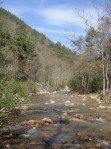
One of the gems of the Mount Rogers National Recreation Area is Fox Creek. Nestled between the south side of Iron Mountain and the north side of Mount Rogers, Fox Creek flows east through about 5 miles of National Forest before entering private property down the mountainside.
Fox Creek
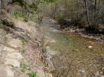
Lower Fox Creek
The lower section of the creek that lies within the national forest flows through a miniature gorge. Large boulders and timbers create numerous beautiful pools of water. Fox Creek Falls, a fan-type cascading waterfall, is a much photographed feature. The photo below shows Fox Creek Falls from a side angle, a less traditional view. (Click on any of the photos in this article to enlarge them.)
Fox Creek Falls
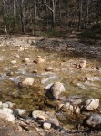
The two trips we took to Fox Creek in October revealed remarkable foilage on the moss-covered boulders. Although past their peak vibrancy, the leaves created a tapestry of color that I needed to capture with the camera.
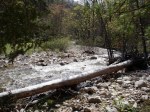
Fallen Timber and Boulders Create a Striking Foreground
The first day we arrived in the middle of the afternoon. The sunlight was too harsh for good photography, so we came back the next day in the later afternoon. The boulders in the creek are quite large; in the photo below, you can see my son Isaac playing on one of them.
One of the Larger PoolsAutumn Leaves Dress Up Huge Boulders
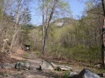
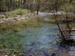
Upper Fox Creek
The upper part of Fox Creek is formed when Lewis Fork Branch joins the Fox Creek headwater. At this point, the creek becomes a full fledged, albeit small, trout stream. A modest, high elevation valley forms between Mount Rogers and Iron Mountain. The National Recreation Area has a large, split rail fence that runs along Virginia Route 603 for several miles.
Along this section of road is the trailhead for the Mount Rogers Trail, Grindstone Campground, a parking lot for the Appalachian Trail, the Fairwood Horse Camping Area, and the entrance to the unimproved road that goes up to the Scales area of Pine Mountain.
One Entrance to Upper Fox Creek
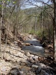
Fox Creek in this area is a small, swiftly moving creek with a gentle gradient remiscent of a Midwestern trout stream or an Eastern chalk stream as much as typical freestone stream. However, the flow of the creek is variable as it is dependent on runoff from Mount Rogers.
Stalking Wild Trout
The views up and down the valley are Western-like. In fact, much of the Mount Rogers area reminds many people, including me, of the West. It’s like a little slice of the West dropped into Southwest Virginia.
Evening Glow in Fox Creek MeadowFly Fishing for Wild Trout
The large meadows along upper Fox Creek provide many starting points for short hikes. There are also numerous places to begin longer hikes up Mount Rogers or Iron Mountain.
This is the second article in my short series on the New River. This summer we canoed and fished several sections of the New River, first exploring the upper section in North Carolina, then the middle section that flows through Virginia, and finally the section that flows through the New River Valley and into West Virginia. In the first article, I reviewed the section of the New River below the confluence of the North and South forks of the river. This article is about our second trip where we fished and camped at Foster Falls in August 2011.
The Cliff at Foster FallsShallow Water and Rocks Visible at the Falls
The New River leaves Ashe County and Alleghany County in North Carolina and crosses the state line and flows into Virginia at Mouth of Wilson in Grayson County. It then briefly crosses back into North Carolina and then back into Virginia again near Fries, Virginia. The river then flows through the eastern part of Grayson County and into Wythe County. As the river flows through the eastern part of the Appalachian Mountains in these counties it gains considerable volume and size as various tributaries add water to its flow.
Shortly after flowing under I-77, the New River has a series of step-like waterfalls that spand the entire width of the river and are collectively classified as a class 3 whitewater. This area is known as Foster Falls and is the site of Virginia’s New River Trail State Park.
Great Biking
The New River Trail State Park is a unique Virginia park: A 57-mile linear state park with various facilities located at different segments of the trail. The main facilities are located at Foster Falls, where there is a small “walk in” campground, river access for fishing and a boat ramp, picnic areas, horse stables, and a canoe livery with a small shop.
The New River Trail itself is a converted railroad bed. The trail is a packed dirt/ash trail that is excellent for mountain bikes or cross bikes. The trail has several trestles that cross the river and also has a tunnel or two that cyclists travel through. The trail is a level grade, with only a few minor hills, and generally follows the New River between Fries and Pulaski. Foster Falls is the approximate half-way mark on the trail, and makes a good base camp to cycle in either direction on the trail.
This trail is scenic with minimal traffic and road crossings. After the Virginia Creeper Trail, it’s probably the nicest off-road cycling trail in Southwest Virginia.
Smallmouth Country
Low water allowed for great wet wading and fishing
The New River is renowned as one of the premier smallmouth fisheries in Virginia. Actually, it’s one of the premier smallmouth fisheries in the United States. The river also has large populations of musky and other game fish. The New holds Virginia’s state records for largest smallmouth bass (8 pounds, 1 ounce) and largest musky (45 pounds, 8 ounces.)
Isaac nabs a nice 14 inch smallie
There are several areas to fish right at Foster Falls. I believe the key to fishing any large river, but especially the New, is to spread your casts methodically over fairly large areas of water to reach the most fish as possible and then move on. Unless you are bait fishing and patient, covering a section of water and then moving on to another section is the best way to cover this river.
We therefore first bank fished the river, then waded parts of the river where it was shallow and fished across a large island adjacent to the campground. I fly fished with streamers and caught about 10 smallies with a size 8 olive wolly bugger. My sons Karl and Isaac used Mepps and Blue Fox spinners on light and ultra light spinning tackle. They caught about a dozen fish between them.
Great Camping
Foster Falls campsite. The New River is seen right behind the campsite.
There are only 12 campsites at Foster Falls. Thus, although it is a group camping area, the sites are dispersed and there is a wonderful absence of what I sometimes call the “Camp Jellystone Effect”−hundreds of sites jammed together creating a permanently smoky area that from a distance resembles a foreign refugee encampment as sometimes seen on the evening news.
The Falls Near the Camprground
Also, because these are “walk in” sites, there are no RVs or trailers. You have to park in a designated parking area and carry your camp gear between 100-200 feet to the designated campsites. This is not that difficult, and, much to my surprise, the state park provides little wagons for campers to transport their gear from the car to the campsites.
"Walk In" Campsites
Most of the campsites are either right on the river, or very close to the river (with river views). The camground also provides a sheltered area with dry wood for the campers. You simply have to pay a daily fee, and then you may transfer the firewood to your site for your own use. This was convenient and a reasonable way to provide firewood (if you run out, you simply go back to the covered area and get a few more logs).
Kayaking and Canoeing
Although we didn’t do any boating, there is the possibility of boating both up river and down river from Foster Falls. Running the falls looked a bit sketchy. When we were there in August, there did not appear to be sufficient water to successfully navigate the falls. We saw one kayaker dragging his kayak down the river; it didn’t look fun.
I have kayaked the section of the river above the falls previously (my brother-in-law once took me down this section when a summer lightning and thunderstorm developed in which I feared for my life−getting caught on the water under these conditions can be scary). During higher flows, this can be a moderately challenging kayak with lots of riffles and fast water, but there are not too many obstacles. Downriver from the falls the river slows considerably as it approaches and eventually forms the upper part of Claytor Lake.
Kayaker Down River from Foster Falls
We will definitely return to Foster Falls, probably with a bike focus on our next trip. However, I will also have to bring more marshmellows, Hersheys chocolate, and graham crackers next time. Because this time, these ingredients seemed to mysteriously disappear each night.
This photo taken with a point-and-click camera shows Brumley Creek the day after the heavy rains from Tropical Depression Lee last week. Normally, this creek is only about 10 feet wide during low water. As a point of reference in the photo, the distance from the bank on the right side to the large tree in foreground in the middle of the creek is about 15 feet (and the width of the stream from the tree to the other side is at least about another 10-15 feet).
Brumley Creek Flooding
We went down to the creek in the evening to look around, and to see how high the water would have risen from the storm water runoff. Usually this section of the creek is quiet, but there was a roar from the water that you could hear as soon as you opened the car door.
How do trout survive in such a rapidly changing environment? This week over at the Orvis Fly Fishing Blog Drew Price explains. Simplifying the explanation, the torrential flow we view from surface is moderated at the bottom, and there are places where the fish can hold and stay safe.
A little bit about Brumley Creek: Technically, it is the closest trout stream to Abingdon. It’s a small stocked creek less than 10 miles from town. It doesn’t have a reputation for producing large or many fish, as there are not many holdovers from the previous seasons. It’s also not regulated, i.e., it’s open to all fisherman who hold a trout license during the stocking season. As stated above, it’s also small. It’s still a pretty little creek though.
Note that this description is of the stocked lower section of the creek, which has about 1/2 mile or so of fishable water, on Trout Road. The creek flows from Hidden Valley Wildlife Management Area and down off of Clinch Mountain.
This 12″ brown trout was caught (and released) today in Wythe County on a Royal Parachute Madam X, aka PMX, a dry fly that is a terrestrial pattern similar to a Royal Wulff with a caddis-type hackle and rubber legs. It looks a little bit like a lot of different types of insects and is an attractor fly as well. The brown trout hit the dry fly pretty hard, which was a nice ending to an otherwise quiet day on the water that seemed to be mostly about casting practice. But with temperatures reaching 96 degrees in the region, wet-wading and fishing a cool mountain stream was a nice start to the Labor Day weekend.
Notwithstanding that the local watershed continues to be low and unreplenished due to lack of big storms, there is still some good fly fishing to be had towards the end of this summer in the high mountains.
Working a Section of a Creek in August
This August fellow Abingdonian, outdoorsman, and neighbor John Hortenstine, my son Karl, and I took a mid-week, evening fly fishing trip to one of our local trout streams in Southwest Virginia. John took us out to one of those relatively unknown spots that anglers usually don’t reveal on websites.
Blindfolded and sworn to secrecy before we were allowed to enter his car, John drove us to a secluded stretch of water where we were treated to some nice fishing. Once on the water, John and I took turns working the various pools as we worked our way upstream. Karl started several pools downstream and brought up the rear as a sweeper, fishing each of the downstream pools after they were rested for a while and documenting our trip with photography.
Only John was getting all the action when we started out. While he might contend it was solely due to the skilfulness of the angler in question, at the time I suggested it was the fact that he was using a lighter tippet (the final part of the line that connects the leader to the fly), and that the fish were more interested in the particular pattern, or type, of fly he was using. John caught several nice fish right out of the gate, while my dry fly was just getting some rises and some looks, but the trout were ultimately not interested in the Parachute Adams I was offering.
SW Virginia Rainbow
When the water is super low, your approach is a big part of the fishing. “Spooking” the fish by a clumsy approach will dampen, if not totally destroy, your chance of catching trout. While the water is not always extremely clear in the Appalachians, when it’s low like it is right now in late summer, the fish will easily spook if you are not cautious. Even poor or unnecessary false casting of the fly line (where the line shoots out over the water before the actual cast of the fly out onto the water) will spook a rising trout in these little creeks.
Stealthy Approach to Trout-Laden Pool
Of course, the flip side to the low water is that you have a better chance of actually seeing more of the trout in the pools and other places where the fish are more likely to be holding in the smaller water. We saw several trout at a time in some of the pools, and a few were lunkers.
An additional benefit to being quiet on the water is that you may see additional wildlife. About halfway through our fishing, a small deer busted through the brush at the bank less than 100 feet from where we were fishing, and stopped right in the middle of the stream. It froze for a few seconds when it saw us. Then it crossed and was gone.
As we were fishing in this fashion, John had one rise—and a sip, or take—by a particularly large trout in a 2 foot slow-moving pool of clear water. The top part of the trout actually broke the surface of the quiet pool as it opened its jaws and slowly and deliberately sipped the fly. I immediately estimated this trout was 18-22 inches! It was clearly visible in the water since the entire length of the trout was only an inch below the surface at the time it sipped the fly. We both watched mesmerized. Seeing a take like that is impressive on any level, but when it is your fly that is being taken it can send chills up your spine. You draw in your breath with a silent gasp and your heart skips a beat. This is what a dry fly fisherman lives for.
There was a momentary pause—we both knew this was a great fish. Then, timing it properly, John attempted to set the hook . . . but just at that moment the lunker ejected the fly as deliberately as he had taken it. The fish turned and returned to his lie at the bottom of the pool as the leader and tippet with the fly attached was withdrawn back towards us. The whole thing almost seemed to happen in slow motion. Watching it was agonizing, but awesome.
John's Nice 'Bow Caught on a Dry Fly
Setting the hook with a dry fly on a rising trout is much more difficult than on a nymph or streamer (let alone setting the hook using spinning tackle), because with the dry fly there is a longer period between the fish’s actual strike, or take, of the fly and the moment to set the hook. Getting the timing just right to set the hook while the fly has been taken, but before it is ejected, is challenging. While there are sometimes violent strikes, if the trout are rising and merely gently sipping surface flies, the angler must concentrate, time the hook-set perfectly, and generally use more finesse to catch the fish. A large trout like the one we almost caught may be even more finicky, as it may have been caught before and is probably even more cautious than most fish. It takes a lot of skill, and also a little bit of luck, to catch a seasoned trout on a dry fly.
My Turn
After a while, we finally switched out my rig to use a smaller (6X) tippet and to change my fly to a pattern similar to the one John was using. Within a few minutes I started to get some rises and more interest from the trout. I had several takes, but also was unable to set the hook. Towards the end of the evening, however, I caught a beauty, too:
My Colorful August ‘Bow
In the end, there was plenty of wealth to spread around. Last but not least, Karl got into the action with a nice, fat rainbow in one of the largest pools we fished. He now has the fly fishing “fever,” too: He is getting his own fly rod for the fall.
This was a great little evening of fishing. Willing trout, close to home, and a cool summer evening: It’s hard to beat that.
P.S. — John did not really blindfold us; we were, however, truly sworn to secrecy!
This is the first of a short series of articles that will examine the New River, the largest river which flows through Southwest Virginia, and the source of great outdoor opportunities in the region including paddling and fishing.
Canoeing the New River in the North Carolina "High Country" - Click to Enlarge
Purportedly the second oldest river in the world (only the Nile in Africa is older), the New River predates the Appalachian Mountains (themselves some of the oldest mountain ranges in the world). Geologists explain that this river existed before the tectonic shift that caused the uplift of the Appalachia range. The river more or less continued its present-day path during the tectonic shift, cutting through the mountains as they were created.
The New begins high in the mountains of northwestern North Carolina. The New actually starts as two rivers, the North Fork and South Fork of the New. These two forks join in Ashe County before flowing north and west through Virginia into West Virginia. The mighty New ends when it confluences with the Gauley River to form the Kanawah River, which flows into the Ohio River at the West Virginia/Ohio state line.
In the 2001 bestseller Far Appalachia, author and radio host Noah Adams travelled the length of the New River from North Carolina to West Virginia, recounting the scenery, his interactions with local residents along the way, and his autobiographical musings about his own family’s heritage in the region. In the book, Adams notes that there are two views as to the source point, or the true beginning, of the New. On the South Fork, it is somewhere near Blowing Rock; on the North Fork, it is somewhere on the upper part of Snake Mountain, one of the highest peaks in northwestern North Carolina. (As an aside, Blood, Sweat and Gears, the well-known challenge century road bike race that starts and ends in Valle Crucis, NC every June, traverses the high road over Snake Mountain. I can attest it is very difficult climb on a road bike.)
My son Karl and I did our own “section” paddle trips and travels to different parts of the New River Blueway, or paddle trail, over the course of this summer. For non-hiking readers, a “section” hike is the partial completion of a long trail, like the Appalachian Trail, in “sections”. Most hikers on the AT, for example, are section hikers, not thru hikers. We applied this concept to the New River, taking on several distinct sections of the river to observe and experience the river along its course. This article is the trip report about the first section. In June we travelled from Abingdon to Ashe and Allegheny County to paddle a 13-mile stretch of the South Fork of the New (above the confluence). This section of the New is part of the New River Paddle Trail in North Carolina. An excellent map of the New River Paddle Trail in North Carolina is here.
possess outstandingly remarkable scenic, recreational, geologic, fish and wildlife, historic, cultural or other similar values, [and] shall be preserved in free-flowing condition, and that they and their immediate environments shall be protected for the benefit and enjoyment of present and future generations.
This section of the river is also part of the North Carolina New River State Park (there is also a New River State Park in Virginia, but that is for the next article). We elected to paddle the section from Wagoner Road to Route 221. The trip is about a five or six-hour paddle, not including stops. Here was our route:
Wagoner Road to Route 221
In North Carolina the New River is still a moderately sized river. Both the North Fork and the South Fork are navigable. There are apparently some trout in the upper reaches of the New River, most notably high on the North Fork section. However, where we were paddling the river was already somewhat warm (compared to trout waters). The section of the New from the confluence to the Virginia state line is supposed to be a fairly good smallmouth fishery. We were above that section. We fished the 13-mile stretch of the South Fork intermittently with light spinning tackle, and did not catch anything.
Yes, That's Really Rhododendron on the River! - Click to Enlarge
The flora up in the North Carolina High Country is a bit different from down in the New River Valley in Virginia. For example, there were rhododendron on the banks of the river and stands of pine trees mixed in with the hardwoods.
Make no mistake, although moderately sized, this is still a powerful river. There are numerous boulders and riffles that I imagine cause current changes to a much greater extent when the river is at a higher cubic feet per second (CFU). We ran the river in low water, however it is probably quite a different river during the springtime. On this section of the New, where it is designated a National Scenic and Wild River, there are relatively few homes or other signs of development. You go through whole sections of river where the trees come right down to the water, and there are no homes visible up river or down river.
Geese and Goslings
On this paddling trip, we saw geese, beaver or otter, osprey, and ducks. There were also hunting blinds set up in some of the open fields along the river. The water along the 13-mile stretch we paddled was mostly flat or moderate Class I rapids. There were a few submerged rock shelves over which we had to paddle, and we almost bottomed out in a place or two.
Overall, this is a nice paddle trip. It may be a bit long for some folks. There are shorter alternatives along this route, and both up river and down river from the section that we completed. The New River State Park has several access points.
One thing we did not do, that should be done if you are in the area, is have breakfast or lunch at Shatley Springs Inn, an old inn and restaurant that is a true old-timey place renowned for its family style dining with delicious North Carolina country food.
Breakfast at Shatley Springs and/or a canoe trip down the New would be an excellent day trip down from a camping trip in the Mount Rogers National Recreational Area in Virginia. We have in fact done this in the past.
Cumulus Clouds Over the New River
Directions
It takes about 1 1/2 hours to drive from Abingdon to the Route 221 Bridge crossing (where the New River State Park is located, and where we rented our canoe). From Abingdon, drive to Damascus, then up Route 58 past the Beartree Lake area. Up on the mountain, Route 58 makes a sharp right-hand turn. You can continue on Route 58 through Whitetop, or instead stay straight on Route 603, aka Konnarock Road. Either one will eventually take you to Route 16/Route 58 south. I prefer going via Route 603 over to Route 16, as it is a straighter road.
At Route 16/58 head south to Mouth of Wilson. Drive through Mouth of Wilson. Here Route 16/58 split. To get to the New River State Park at the Route 221, bear left and stay on Route 58. After about 1 mile there is a junction with Route 93. Turn right on Route 93. This turns into Route 113 at the NC state line.
Drive on Route 113 for about 8 miles, until it junctions with Route 221. (At this intersection is a BBQ restaurant called Motleys.)
Make a right on Route 221. Route 221 is a very twisty road, taking you through the small community of Scottsville, NC (just a few homes and churches) and after about 5 miles on Route 221 you will see the signs for the New River State Park. A nother mile or so and you will cross the New River. Immediately on the right there is an old General Store with inadequate parking right on Route 221. Behind this store is New River Outfitters.
Note: There are plenty of other outfitters in the area. National Geographic makes an excellent map of the entire New River watershed, it is Map 773, New River Blueway, and it contains names of most of the outfitters in NC, VA, and WV with their locations identified clearly on the map.
Note: This area of North Carolina is very rural, and the roads are very twisty. Getting around is not intuitive until you know the roads. Carry a good map, use a GPS, etc. In addition, this makes getting to and from the canoe/kayak drop off points difficult. This is another reason using an outfitter in this area is good idea.
This weekend was a fly fishing marathon of sorts. My son and I covered three different streams in three days, shopped for fishing gear and talked fishing with numerous people about fly fishing, researched fishing opportunities around the region, and caught some nice fish while escaping the oppressive heat that seems to have taken the nation hostage this summer. On Sunday afternoon, I caught my first large rainbow trout since purchasing a new fly rod.
Southwest Virginia Rainbow TroutBeautiful Rainbow on a Sunny Afternoon
As you can see from the photo above, this fish was about as long as my forearm from elbow to the middle of my hand. We estimated him about 15 inches and about 2 pounds. I caught him with a nymph in about 1 1/2 feet of water near a cut bank. My rod was a 5 wt, and I was using 6X tippet. He jumped once and ran twice, the second time pulling line out from the reel. We enjoyed that sweet whine of the drag as the trout pulled the line as he straight-lined it up river. We had about a five minute fight to get him close enough to bring him in, and we promptly released him.
The Catch
The Release
This is a great time of the year to get up into the mountains for recreation since it has been so hot lately. We enjoyed temperatures in the low to mid 70s most of the time we have been fishing this weekend. That said, the water is extremely low, so the fish may not be as responsive as at other times of the year. The heat puts a lot of additional stress on trout, who require the colder water to survive. We therefore have minimized the length of fights or playing the fish out too long, as in the heat it is difficult for them to recover.
Fly Fishing Somewhere in Southwest Virginia
The Southern Appalachians boast some of the best fly fishing in the Eastern United States. That declaration, while seeming strange on its face—fishing for trout, a cold water fish, in The South?—actually makes a lot of sense when you think about it. Streams and rivers originating from springs and filtered runoff from mountains, relatively remote pockets of forestland, and steep valleys providing lots of cover and protection from the heat of the sun combine to make the streams of this region good for trout. Within a 60-mile radius from Abingdon there are numerous “blue ribbon” trout streams in Virginia, North Carolina, and Tennessee that provide first class fly fishing opportunities. Many are tight creeks and smaller streams, but there is definitely some wonderful fly fishing in this area.
Little Southwest Virginia Rainbow
The Virginia Department of Game and Inland Fisheries is a good place to start to get some basic information on regulations and fishing locations in Southwest Virginia. Abingdon is fortunate to have an excellent and well-equipped fly fishing shop, Virginia Creeper Fly Shop, whose owner Bruce Wankel is always welcoming, provides useful information, and also guides local waters. Mountain Sports, Ltd. in Bristol also sells fly fishing specific gear and has knowledgable staff about fly fishing in the region.
St. Mary’s Wilderness is in the George Washington National Forest in Augusta County. St. Mary’s River, a small river that is better characterized as a large creek, empties a large drainage area on the west slopes of the Blue Ridge Mountains. It’s about three hours from Abingdon via I-81. In fact, it’s as close to Washington, DC and Richmond as it is to Abingdon.In April 2011 I hiked and did some trail running up the main St. Mary’s “trail”—if you would call it that—on a weekend trip to the Shenandoah Valley. The last time prior to this that I hiked in the St. Mary’s Wilderness was as a student and member of the Washington & Lee University Outing Club in the late 1980s. Unlike most hiking areas, St. Mary’s Wilderness has become more inaccessible since my trips there when I was in college.
There is a sign at the entrance to St. Mary’s Wilderness that states that the trail was destroyed during Hurricane Katrina in 2005. There was a well-established trail prior to the hurricane. Now it starts out as a trail but within a half-mile deteriorates to sporadic rocky areas and only remnants of a trail. There are numerous areas where the “trail” is blocked by blow-downed trees, and where the trail meanders or peters out and then reappears several hundred feet further along the river. The trail also runs along some embankment areas that are somewhat dangerous, requiring hand-holds on tree branches. This trail could be challenging with a large, heavy pack for these reasons.
Due to limited time, I was only able to get several miles up the trail, so I cannot comment on the further reaches of the trail. However, the lower areas are not in very good condition. In fact, the conditions were so poor that I carefully retraced my hike back to the entrance parking lot, to make sure that I had not missed the trail somehow. Considering that this was early in the season, with the leaves not fully out and the underbrush not obscuring the trail, I do not think was this the case.
While there are interesting cliff faces, views up the gorge, and glimpses of the Blue Ridge mountains above, the reason to hike this trail is the St. Mary’s River itself. The river is clear, runs over a light-colored stone bed, and has a couple of waterfalls. There are also numerous deep pools, several which are suitable as swimming holes or places to take a dip on a hot day. Here is a typical deep water pool:
The St. Marys River is purportedly a good trout fishery. The river is not part of Virginia Department of Game and Inland Fisheries’ stocking program, however it is a designated special regulation trout water. Only single hook artificial lures may be used; no bait may in possession of the angler; and all trout less than the minimum—for St. Mary’s River, a 9-inch minimum—must be released.
Comprising 9,835 acres, St. Mary’s Wilderness is one of the largest federally designated wildernesses area in Virginia. Under the Wilderness Act of 1964 a federally designated wilderness is described as: “A wilderness, in contrast with those areas where man and his own works dominate the landscape, is hereby recognized as an area where the earth and community of life are untrammeled by man, where man himself is a visitor who does not remain.”
Although designated as a wilderness, it is not remote compared to many areas of national forest southwest of Roanoke in the Abingdon area such as the Mount Rogers National Recreation Area, parts of the Clinch Mountain Ranger District, or the Cherokee National Forest in Upper East Tennessee. St. Mary’s Wilderness is nonetheless remarkable for being such a large, contiguous wilderness area so close to the major metropolitan areas of Virginia.
Here are some additional thumbnail photos of the St. Mary’s Wilderness. Click to enlarge them.
Only 45 miles from Abingdon, Bays Mountain Park and Planetarium in Kingsport, Tennessee is one of the nicest large parks in the region. It is right off of Interstate 26, Exit 3, Meadowview Parkway. The entrance to the park is just a few miles to the south of the exit.
With 3,550 acres and an extensive network of 37 miles of trails, it offers a good place to do some trail running or mountain biking in an enclosed, very pretty natural park. The trails are a mix of old fire roads and single track. There are several good annual trail running races within the park, most notably the Bays Mountain 15 Mile Trail Race, which is in September and starts from the nature center area, and the Laurel Run Ascent, which is in April and starts in Laurel Run Park (accessed from Church Hill, Tennessee). I did the Bays Mountain 15 miler several years ago and can attest to it being one of the nicer trail races in the region.
Bays Mountain Park has nature programs and dedicated habitat areas—essentially large pens—for bobcat, wolves, river otters, turtles, and raptors. This area of Bays Mountain Park is similar to the Western Carolina Nature Center in Asheville, North Carolina. There are not as many exhibits at Bays Mountain as at WCNC; however, the wolf exhibit at Bays Mountain is larger and better.
The photo gallery below shows some areas of the park close to the nature center. Click on a photo to see a description of it.
I recently visited Bays Mountain with my son for an elementary school field trip. (This park hosts many school field trips; during our visit there were also school field trips from Scott County, Va. and from Hawkins County, Tenn.). With the school group, we visited the nature center, listened to a lecture on the wolves, and watched a program at the planetarium.
During the wolf lecture, the park official explained how wolves live in packs, their feeding habits and pack behavior, and then demonstrated how the wolves howl. She prompted the wolves to howl with her own human “howl,” which involved cupping her hands to her mouth and then initiating a howling sound and was unlike an ordinary human imitation of a wolf howl. The wolves responded slowly at first, and then all of them seemed to howl together. This lasted several minutes. It was quite loud, actually pretty fascinating to hear, and was the highlight of the trip.
We then proceeded to the planetarium. The planetarium has a modern Carl Zeiss planetarium projector that allows the audience to sit back and look up onto the domed ceiling to watch an accurate representation of the night sky. This was the first time I had seen a planetarium show since I was a child at the Adler Planetarium in Chicago, so it was a treat. The Bays Mountain Park website indicates they also have quality telescopes and allow the public to use them at designated times in the evenings.
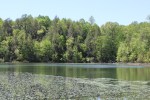
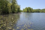
Bays Mountain Park has a 44 acre lake named the Kingsport Reservoir that was apparently originally used as the major source of water for the city of Kingsport. The lake has many inlets, lily pads, and bass and bluegill that were visible from the shore. Overall, this park is a nice asset to the region, one often overlooked as a place for outdoor recreation considering how close it is to Abingdon and Southwest Virginia. It’s definitely worth a day trip.
This weekend two good friends, my wife, and I drove over to Boone, North Carolina for the evening to attend the local screening of the Banff Mountain Film Festival at the Farthing Auditorium at Appalachian State University. The Banff Mountain Film Festival is the largest and oldest film festival for celebrating mountain sports and culture. The festival takes place in Banff, Alberta, and then a shorter version travels around North America (and the world) for screenings of the best films. The Boone screening, a two night affair, is supposed to be one of the largest outside of the actual festival in Banff.
Our road trip was about an hour and ten minutes via Route 91 through Mountain City, Tennessee and up Route 421. As we went through Trade, Tennessee, we were treated to a setting sun shining directly on snow-capped mountains on the North Carolina side of the state line. The upper half of the mountains had a nice dusting of fresh snow that looked like someone had dumped powder sugar on them. Apparently it had been snowing all day in the higher elevations, setting the mood nicely.
Arriving at Farthing Auditorium, the crowds were raucous, and there was a lot of energy anticipating the screening. We watched five films. WildWater, Eastern Rises, and The Swiss Machine were the most memorable. WildWater is about the spiritual aspects of paddling in wild places and the devotion of those who paddle. The film contained incredible footage, including creek boating in Colorado, rafting in the Grand Canyon, and the massive rapids of the North Fork of the Payette River in Idaho during high water.
Eastern Rises seemed to be the best liked film of the night. It documented a bunch of guys who took an incredible fly fishing trip to Kamchatka, Russia. Kamchatka is one of the most remote areas of the world: A vast, basically unpopulated peninsula across the Bearing Sea from Alaska and to the north of Japan and China. In the film these guys fished super remote rivers and streams, many without names. The trout were huge, and they were rising to go after gigantic custom-tied flies. The guys’ reverence for trout fishing and the pristine waters they fished came through, and their irreverence towards one another was hilarious. This is one entertaining movie regardless of whether you are personally into fly fishing.
The Swiss Machine was an adventure biography of Ueli Steck, an alpinist who is a speed climber. The film shows Steck climbing in the Himalaya, Yosemite, and in the Alps. The film leads up to his speed ascent of the north face of the Eiger. Viewing the steepness of the Eiger face on the big screen almost made me queasy. The filming shows how dangerous speed climbing can be. Yet the film is quite inspirational. Steck’s athleticism and determination are well conveyed for such a shorter film. The cinematography in the final scene is superb.
Coming back from the screening, appropriately enough it began to thunder snow on the drive home. This is in April in Virginia, mind you. There are additional screenings of the Banff Film Festival in other places this year. This was the first year I was able to attend the annual festival; if you have a chance to see it sometime, I highly recommend it. It’s inspirational and definitely makes you want to go get into the outdoors in the mountains.