High up on Pine Mountain in the Mount Rogers National Recreation Area is an area known as the Scales. This June we drove and hiked up to this area.
The Scales
Basically, it’s nothing more than a grassy, fenced in area used by campers and horse riders. On the other hand, the Scales have been for many, many years the eastern gateway to the high country of Mount Rogers, where ranchers brought their cattle to graze in the summer and then sell during earlier in the 1900s. Livestock was weighed up here (thus the name “Scales”) before the animals trekked back down off the mountain and lost weight (and brought their owners less money when sold).
Forest Road Warning
The Scales are located above 5000′. The Appalachian Trail crosses right above this area. The most direct route from below is Route 613, which is a rugged, rock strewn forest road that requires a high clearance vehicle.
You need a rugged, high clearance vehicle for Route 613
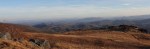
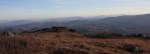
The road eventually crosses a cattle guard. Shortly thereafter the forest opens up to show Pine Mountain and some good views to the north of the valley and ridge mountains in Virginia.
Cattle Guard
The skies always seem to be a deeper color of blue up here on the mountain.
Blue Skies
The photo below shows the numerous mountains visible to the north from the area near the Scales.
This article reviews the newest federally protected area in Southwest Virginia, the Seng Mountain National Scenic Area.
Rowland Creek Falls
In 2009 the United States enacted the Virginia Ridge and Valley Act of 2008. Sponsored by Senator John Warner (R-VA) and Rick Boucher (D-VA), the Act preserved over 50,000 acres of wilderness areas in the western part of Virginia. Part of the Act created the Seng Mountain National Scenic Area, a 6,500 acre tract, and the Bear Creek National Scenic Area, a 5,500 acre tract (I will review the Bear Creek National Scenic Area in a future article). See16 U.S.C. § 546b. The designation of these tracts as “scenic areas,” as opposed to “wilderness,” was a compromise to allow continued non-motorized recreational use by cyclists (mostly single track mountain biking).
Some groups and individuals have known about this part of the northern ramparts and mountainsides of Iron Mountain for a long time. The Seng Mountain area has been part of the Mount Rogers National Recreation Area for 25+ years. The scenic area designation simply gives it more protection and makes permanent the designation of the area as one for the limited recreational uses enumerated in the statute. Ok—enough with the legal mumbo jumbo—let’s talk about the area itself:
The area is located in the southern section of Smyth County and is about 30 miles as the crow flies from Abingdon. Its boundaries are roughly Route 600 (Skulls Gap) on the west, Hurricane Campground on the east (off of Route 16), Forest Road 84 near the top of Iron Mountain on the south, and private land near the Stony Battery community on the north.
There are two major single track trails that cross the scenic area, Jerrys Creek Trail on the west side, and Rowland Creek Trail on the east side. Each of the trails follows a small creek that runs down the mountainside. The high point in the scenic area is Round Top Mountain, 4626′.
Mountainsides Draw Close Together to Form Miniature Gorge
In mid-April my family and I drove to the upper trail head of Rowland Creek Trail. Our starting point was at 3850′. You reach this trailhead by traveling on FR 84, which is a gravel forest road. Getting to the trailhead from Route 600 takes about 20-25 minutes.
This is an unusual mountain hike, in that the hike starts the top, so you start hiking downhill, and return going back uphill. Rowland Creek trail starts out wide as it descends around Seng Mountain, down towards the headwaters of the creek below. The area forms a mini-gorge, as the mountainsides are steep and drop quickly down into Rowland Creek.
Rowland Creek Trail - Steep Switchbacks
Where we started, on FR 84, there were no leaves. However, within a half mile of going down the trail, we descended into the foliage of springtime. The protection of the gorge-like formation protects the trees below from the elements, creating a micro-climate that is much milder than at the top.
Leafed Out Trees Below Contrast with 4000'+ Bare Ridge Lines
After several switchbacks, you arrive at the headwaters of Rowland Creek. There are some nice potential campsites at the upper end of the trail, within easy walking distance of the creek.
Moss Covered Rocks and Boulders Photo by Karl Thiessen
One thing we noticed is that the trail was quite moist and rutted out from horses near the creek. It is probably extremely muddy after rains. The trail roughly parallels the creek the rest of the way down the mini-gorge.
The area along the creek is lush. We spotted numerous flowers. A bit of research shows that the trilliums we saw are native to the Southeastern United States, particularly in mountainous, gorge-like hollows such as that on this trail. They bloom in April or May at the earliest, while sunlight reaches the forest floor before the trees are fully leafed out.
Southern Red Trillium Photo by Karl Thiessen
One thing we were not anticipating, but had some fun with, were the creek crossings.
Rowland Creek Crossing Number 1
While none of the creek crossings were too difficult, we were hiking after several dry days. The trail could likely become completely washed out, and the creek crossings more difficult (at least to get across without getting soaked) under wetter conditions.
Rowland Creek Crossing 2
Even our dog, Magnus, was enjoying the creek crossings (here is creek crossing 3):
The highlight of this trip is most definitely Rowland Creek Falls, a 50′ cascade-type waterfall that drops down a series of stairs for about 80-100′.
Upper Rowland Creek Falls
The falls are not directly on the trail, so we needed to go down a hill in order to get some clean shots of the cascades.
Multiple Cascades
My son Karl made it all the way to the bottom and took some nice shots of the lower end of the falls, including this photo:
Lower Rowland Creek Falls Photo by Karl Thiessen
Below is a map of the entire scenic area. Rowland Creek Trail and Jerrys Creek Trail can be connected by either FR 84, or an older, no longer used forest road that parallels FR 84 about 100′ downslope of it. This loop is about 12 miles in length. It is also used by mountain bikers, although there are sections that are very difficult due to the grade and the wetness near the creek beds.
This March we visited Linville Falls, one of the most famous waterfalls in North Carolina, during the 2012 Banff Film Festival in Boone (the inspirational film festival trailer can be seen here). The falls are located just off the Blue Ridge Parkway at mile marker 316. There is a visitor’s center and a short hiking trail (about .8 miles) to the falls.
Water Swirls Around Ancient Stone
The closest viewing area shows the upper falls (not pictured here) in one direction, and beginning part of the lower falls in the other direction. The photos above and below show the beginning part of the lower falls. The lower falls churn through a cavernous semi-circle of eroded limestone, and then plummet about 45 feet into a large pool.
Water Diverted in a Semi-Circle Above Linville Falls
“Chimney Rock Overlook” can be seen from the upper viewing area, as highlighted in the photo to the right. From Chimney Rock Overlook, you can see the lower falls in their entirety, as well as the large cliffs that surround the falls and mark the beginning of the Linville Gorge.
Highlighting the Overlooks Shows the Scale of these Falls
The cliff face next to the lower falls is as impressive as the falls themselves. When we viewed the falls, there was a relatively large volume of water flowing. This caused the falls to jettison outward from the upper pool.
Linville Falls is a very popular stop on the Blue Ridge Parkway (the parking lot at the visitor center is huge), so it is recommended that if you want to visit the falls without hordes of tourists, you should try to see them during less visited times of year such as in spring or winter, or during the middle of the week.
The viewing areas were built in a manner to try to fit into the natural surroundings and are constructed of stone and logs. When they are wet, it is possible they could be treacherous. In particular, the Chimney Rock overlook could be dangerous if someone got too close to the edge of the viewing area, as a fall from that location could be fatal.
The Linville Gorge is one of the deepest gorges in the Eastern United States. I have seen claims that it is in fact the deepest, but there are several others that are comparable (including the Russell Fork Gorge in Southwest Virginia). Suffice it to say that it is deep and impressive. Experienced hikers have become disoriented and lost in this place.
Linville Falls from Chimney Overlook
The Linville Gorge reminded me of the gorge below Abrams Falls close to Abingdon, although without doubt the Linville Gorge is much deeper and longer.
If you find yourself in Boone, Blowing Rock, or on the Blue Ridge Parkway in this neighborhood, a trip to Linville Falls makes for a nice day trip and provides a nice little outdoor experience without too much effort.
Most folks who visit Blowing Rock, North Carolina are on vacation from far away, usually in summer to escape the oppressive heat in places like Florida or maybe Charlotte or Atlanta. Not so for Abingdonians—for us, it’s just hop, skip, and jump over the mountains. It’s exactly 60 miles from Abingdon to Blowing Rock. Perfect for a day trip.
Well Maintained Carriage Paths Encircle Bass Lake, March 2011.
About a mile outside of Blowing Rock, just off Route 220, is the entry to Bass Lake, part of Moses H. Cone Memorial Park. An easy day trip from Abingdon (although certainly meriting a long longer trip if desired), the Moses H. Cone Park is a large, outdoor park managed by the U.S. National Park Service.
Moses H. Cone Mansion, circa 2007
We have been visiting this park for years. One of our spring rituals, when it’s warming up and we are getting cabin fever, is to come over here on a March weekend, before the crowds swarm Blowing Rock.
The walk around Bass Lake, about a mile, is the perfect family walk. There are a multitude of trails lacing the park that go far beyond the lake. A map of the trails, somewhat dated, from the National Park Service is located here.
Mrs. Abingdon Outdoors Revealed: Joanne and Isaac on the porch rail of the Cone mansion, circa 2007. Note the view of the lake in the background.
This is a great place to come to relax—lunch at one of the many restaurants in Blowing Rock and a stroll around the grounds of the estate makes for a nice day.
Aqueduct leading to Bass Lake. Note the mansion at the top of the photo.
Moses H. Cone was a textile magnate that built his country estate in the very early 1900s similar to Vanderbilt’s estate in Asheville. The Cone estate is not quite as exorbitant as The Biltmore, but with 3,500 acres of land and a 13,000 square foot mansion that overlooks the mountains, it’s undeniably grand. The estate was designed with the mansion, which sits at about 4,500′, overlooking the man-made lake and the carriage trails that meander down towards Blowing Rock. More information on the background to the creation of the estate is located here.
The house is open to the public, and is accessed off of mile 295-298 of the Blue Ridge Parkway. While the mansion is worth a visit, what keeps us coming back are the grounds. Imagine Virginia Creeper Trail type trails: well-maintained cinder or pea gravel covered trails.
Future Runner Practicing on the Carriage Path, March 20, 2011
The trails crisscrossing the ground make for an excellent area to train for running. In fact, most times you are here you will see some locals, part-time residents, or visitors running on the carriage trails. Next time you are in the Boone-Blowing Rock area, check out this park. You won’t be disappointed.
Check out these photographs of falcons and falconry from a new Northern Virginian blog on photography. Falconry, the ancient sport of taking quarry with raptors, is not widely practiced in the United States, although there is a Virginia Falconers Association.
A Falcon's View in Tennessee
If you investigate a little bit you will learn there is normally an “apprenticeship” whereby an aspiring falconer will work with a more senior bird handler to learn how to trap, manage and train a falcon. The apprenticeship may take years. Falconers must obtain U.S. Fish and Wildlife Permits in order to trap and keep these birds.
Having a falcon return to you and land on your arm would be exhilarating—presuming, of course, that you were wearing a protective gauntlet (otherwise your exhilaration would be tempered by extreme pain as the raptor’s talons clamped down on your forearm).
These photos reminded me of a backpacking trip a friend and I took several years ago wherein we accidentally came upon several wild raptors that flew extremely close to us. It was a bit unnerving to have birds of prey buzz so closely by. A few minutes later we would realize why the birds were flying so close to us.
We were hiking the Appalachian Trail in the Bald Mountains, up on the North Carolina-Tennessee border about 10 miles north of Sams Gap. As we rounded some large boulders, we accidentally came upon the Big Bald Banding Station. There were some individuals near the summit of Big Bald Mountain collecting data, and there were birds of prey that were either nesting or returning to the area. There were also some large bird cages, and, if I recall correctly, we observed several birds being released.
The sheer randomness of our coming upon these guys and watching the magnificent birds was pretty neat. In fact, we were so surprised that neither of us remembered to take our cameras and photograph the birds. We probably could have gotten some shots like those in the article highlighted above. The birds we saw were not trained, but were wild and free and were probably just passing through, stopping briefly on their way south for the winter.
On Top of the World - Eastern Falcon Migration Throughway
Big Bald Mountain, at 5516′, is one the higher points on the AT (and the highest between the Roan balds to the north and the Smokies to the south). The hike on the AT from Spivey Gap (Route 19W, aka Spivey Mountain Road) to Big Bald Mountain is a steep, rugged hike. The Bald Mountains are a natural bird migration throughway, and both large birds and smaller species cross the mountain during the seasons.
Southern Exposure: View of the Smokies from Big Bald Mountain
Immediately above the confluence of Little Brumley Creek and Brumley Creek on Clinch Mountain is a unique 16-20 foot plunge-type waterfall known as Little Brumley Creek Falls.
Little Brumley Creek Falls
This past weekend some friends, my son, and I hiked, climbed across mountainsides, and otherwise bushwhacked through state forest to reach this remote waterfall.
This waterfall is unique in that the waterfall drops over a huge slab of overhanging rock. There is a shallow cave behind the falls. You can actually get up in the cave and walk behind the falls.
Little Brumley Creek Falls Front View
Here is some footage of my son and another person in our party walking behind the falls:
In 1934, the Civilian Conservation Corps began construction on the trails of Hungry Mother State Park in Marion, Virginia. In 2012, the trails still provide hikers, runners and mountain bikers great recreation opportunities.
The Promentory on Top of Molly's Knob
In late October 2011, my son Isaac and I (with my daughter Josephine in a backpack carrier) hiked up to Molly’s Knob, the highest point in the park. This is a classic day hike in Southwest Virginia. Molly’s Knob is a sharply rising promentory knob that is about 3500′, rising slightly over 1000′ from the lake. The hike from the lake is about three miles, making for a six mile round trip.
Hungry Mother Lakeshore
Over the years, Hungry Mother State Park has been a major training ground for me, particularly for running, mountain biking, and kayaking. The trails are not your typical Southern Appalachian foot trails—we’re not talking root-laden, AT-type trails.
As you would expect for trails constructed by the CCC, these are similar to the U.S. National Park trails across the country. The trails are wide enough in most places for two people to walk abreast together, especially the main trail around the lake (appropriately named the Lake Trail). (If you add about a hundred yards to a run around the lake, you have almost exactly 10k.)
Other than the Lake Trail, the trails weave up and down the mountainside, mostly on the backside of the lake. The map of all the trails is located on the state park website, here.
There is good signage throughout the park; all trails are marked.
The first time I ascended to the top of Molly’s Knob, sometime in the mid-1990s, it was on a mountain bike, and I was huffing and puffing attempting to follow my brother-in-law up the trails. While I still see mountain bikers on these trails, the climb to Molly’s Knob is more enjoyable, in my opinion, as a regular hike.
View of Molly’s Knob from the trail. The knob is about 1000′ feet above the Lakeside Trail.
Most of the trail is a steady climb along ridgelines that gradually ascends the mountain. The last half-mile of the trail is a spur that circles around to the backside of the top of the knob and is quite steep. If you are on a mountain bike, it is probably best to dismount and just hike-a-bike up to the top.
Molly Vista Trail Spur, a steep spur leading to the top. It is about .4 miles to the summit from this point.
The photos above and below show the start of the final, steep climb. It gets considerably steeper than in these photos in the final section.
Close up of the trail marker.
As you climb the mountain, the views of the surrounding mountains begin to open up. Below is one of the first views of Mount Rogers and Whitetop to the south.
View of Mt. Rogers and Whitetop mountains from Molly Knob Trail.
The view from the knob looks southwest, directly down the valley-and-ridges. There is, however, a prominent smaller mountain that rises adjacent to Big Walker Mountain. This is the mountain shown in the photo below.
Late Afternoon Sunburst
In the photo below, you can see the view of the valley below. I-81 runs down there somewhere, thankfully hidden in the folds of the hills, along with the Middle Fork of the Holston River.
Valley View
Below is another view looking south. From this point, at the top of the mountain, you make out Mount Rogers (to the left) and Whitetop (to the right), with Iron Mountain rising about 3/4 of the way up in front of those two peaks.
Mount Rogers and Whitetop mountains as viewed from Molly's Knob.
Below is another view looking out from the top of the knob. There was smoke from a fire in the photo.
View from Molly's Knob.
To the left of the fire, probably too small to be seen in the photo (unless you click and enlarge it), there was a hawk soaring on the thermal upwind currents. It is easily seen in the close-up photo below.
Hawk Gliding on Thermals
This hike was toward the end of October, and while the brightest fall colors had already peaked and passed, there was still some wonderful auburn and golden foliage on the mountainsides.
Late fall colors as viewed from the knob.
Depending upon your level of fitness, this may be considered a moderate or a strenuous hike. It’s definitely one that reasonably fit children over the age of 10 or so are capable of, especially if you pack water, some goodies, and take some breaks.
The three-mile section of the Appalachian Trail from Route 601 to the top of Whitetop Mountain rewards hikers in all seasons. In the late fall and winter, vistas open through the canopy on the mountainside, and the generally clearer skies provide better long-range views.
Hawthorn Berries Contrast Against an Azure Sky on Whitetop
This is a staple hike for our family; it’s distance is just about right as a challenging, yet quite doable hike for children. (It’s also a great training hike.) In late November, my son Isaac and I did this out-and-back hike up to Buzzard Rocks, the name of the rocky outcroppings at the base of the bald on Whitetop. The majority of this hike is in the deep forest, but in the last 1/4 you leave the larger hardwoods behind, go through some smaller scrub-like trees, and eventually come up onto the large Whitetop bald that is visible from most high points in Abingdon.
The view from the top of Whitetop is one of the best in Virginia. Here is the classic mountaintop shot from our hike:
Vista from Whitetop
During the summer, this hike can be the quintessential AT walk through a “tunnel of trees” until you reach the very top. In winter, however, you can look up and down the mountain at the various boulders and formations, and you can peer deep into the forest. In the photo below, the leafless canopy affords a view of the top part of Grandfather Mountain in North Carolina. During summer you can’t see this until you get to the balds:
Grandfather Mountain View from the Appalachian Trail Between Route 601 and Buzzard Rocks
Here, you can see the treeline giving way to the balds as my son and dog climb the trail. Note also that there was snow on the trail. It is invariably significantly colder up on the balds than below, usually to the tune of about 20° if there is any wind. It is almost as if you break out into the jet stream.
Emerging from the Trees Below
We were treated to a large, migrating flock of goldfinches when we arrived at the bald.
Migrating Flock of Goldfinches on Tall Hawthorn Bushes
The large Hawthorn bushes with their clumps of red berries reminded us that fall was almost over, and the Christmas season fast approaching. Soon similar berries would adorn mantles and wreaths as holiday decorations in people’s homes far below.
Outcroppings near Buzzard Rocks
Hawthorn Bush with Berries Screens View of Iron Mountain and Clinch Mountain
The big-ticket item—the main reason to do this hike—is the fabulous view from the top of Whitetop. The Whitetop bald is one of the largest individual balds in the Appalachian Mountains.
Looking into North Carolina
The vistas are superb from the bald. In the accompanying article, I have put together a panoramic photograph showing how expansive the view is. The photos in this article do not capture how open it is on top of the mountain.
High Altitude Cirrus Clouds Give Way to Long Stratocumulous Cloud on the Horizon
The winds picked up while we were at the summit; I estimated they were in excess of 30 or 35 mph. The ambient air temperature felt like it dropped about 30° from when we were below treeline. We only had on t-shirts, and we began shivering. Fortunately, I had come prepared: Out came the down jackets, the hats and the gloves.
Isaac Thiessen in the Puffy Jacket
It was extremely windy; note in the photo below how the wind has inflated my pants:
Eric Thiessen in the Puffy Vest
The Whitetop hike is not only a fabulous hike; it’s relatively close to home. Coming from Abingdon, you never leave Washington County (except perhaps while on the trail at the summit). At about 23 miles from Abingdon to trailhead, the Route 601-Buzzard Rocks hike is the closest access point to Whitetop and Mount Rogers from Abingdon.
These two panoramic photos taken from a recent trip to Whitetop Mountain show the expansive vista to the southeast at the summit.
If you click on them in an updated browser, they should open in a much larger format that is pretty awesome viewed on 16:9 monitor. There is a slight overlap in the two photographs, but together they form almost a single, panoramic image.
Virginia into North Carolina Panorama
The Blue Ridge in North Carolina Panorama
As I state in the main article, the views at the top of Whitetop certainly justify the climb to the summit.
There is also a gravel road from the east side of Whitetop that goes to the summit of Whitetop. It is Route 89, and it connects to Route 600 near Elk Graden. Route 89 is usually open even in winter, although it is covered in snowpack and requires a 4 x 4.
In Washington County, Virginia, less than a score of miles from Abingdon, is one of the most impressive series of waterfalls in Virginia.
Abrams Falls
This October the owner of Abrams Falls, who is an acquaintance and client of mine, graciously took my son Karl and I for a viewing and photography shoot of the falls.
This is a special place worthy of protection and preservation. It’s almost hard to believe such a natural formation exists on private property, right in the most populous county in Southwest Virginia, unknown to most people who live here.
Front View of Abrams Falls
There is a series of waterfalls here, the major of which is a plunge-type waterfall of about 70′ that continues with a secondary cascade waterfall that drops over a series of ledges for another 15 or 20′. The main falls drop into a large, natural amphitheatre of sedimentary rock that forms a semicircle of 180°. Below the falls, Abrams Creek continues to flow through a 500′ deep, extremely steep, horseshoe-shaped gorge for over 1/2 mile.
Boy in Foreground Shows Scale of the Falls
The size of these falls can be appreciated in the photo above. Note the boy in the foreground on the right of the photo; he is almost 100′ from the base of the falls.
Abrams Falls create their own micro-environment. Mist and moisture at the base of the falls make for conditions that allow certain rare plants to grow.
Abrams Falls – The Main 70′ Plunge
Upper Falls
The falls are located on private property not currently open to the public. There is no road directly to the falls. To get to the falls, one must hike in for about a mile. There is not any developed trail to the falls. There are two semi-trails that property owners and trespassers have used. Numerous trespassers have died or been injured over the years trying (without permission of the landowner) to see the falls.
Abrams Creek has several additional noteworthy falls. On our hike, we passed the first, unnamed cataract below. The fall colors were either at their peak, or just slightly past their peak, and made for a great backdrop.
Abrams Falls - The First Cataract
There is another waterfall, I will call it the Upper Abrams Creek Falls, and it is impressive in its own right. It is about a 15-20′ cascade waterfall that spans about 40 feet across. It is at the Upper Falls that the mountains begin to close in to form the gorge.
Abrams Falls - The Upper FallsAbrams Falls - The Upper Falls - The Full Second Cascade
The Gorge
The mountainsides become quite steep downstream from the Upper Falls. Our hike left Abrams Creek at this point, and we began to climb up the mountainside in order to take a safer way to the main falls. This path also allowed us to better view the horseshoe-shaped gorge. The hiking here was strenuous.
The Upper Falls - The mountainside entering into the gorge
The photograph below shows the opposite side of the gorge. This gorge is so closed in that it is difficult to photograph in a way that conveys how steep and deep it is. It reminded me of a miniature version of the New River Gorge in West Virginia, or perhaps even more the Russell Fork Gorge. There are rock outcroppings and cliffs on both sides of the Abrams Creek Gorge. Abrams Creek flows about 500 vertical feet below the highest point of the trail.
Abrams Falls Gorge
We traveled to a point at the top of the mountain that allowed us to view the horseshoe shape of the gorge, and then we began our descent into the amphitheatre where the main falls are located. This descent was quite steep. As we descended, we could hear the ever-increasing sound of the falls crashing on the rocks below. In the photo below, the property owner leads the way down the path toward the falls.
Abrams Falls - Descending into the amphitheatre
The Amphitheatre
The amphitheatre is formed by 70-80′ cliffs that surround the falls. The photo below is from about 3/4 of the way down into the amphitheatre and shows the steep cliff face.
Abrams Falls Cliff
When there is high water, the force of the creek and the falls must be incredible. In the photo below, you can see a large tree that is up against the opposite canyon wall. This tree was about 35′ in length, and could not have been moved even if we had tried to do so.
There were several large, ordinarily immovable pieces of wood that looked like they had been thrown around down into the gorge. It reminded me of the way you might see random timber lodged against the walls of a Southwestern U.S. slot canyon from flash floods. I would surmise Abrams Creek is also susceptible to flash flooding.
Side Wall of the Amphitheatre
While the main plunge is the central scenic feature, the cascades at the base complement it and complete the falls. In the front-on photo of the falls below, you can see how the cascades spread out beneath the plunge.
Abrams Falls - The Main Lower Cascade
The falls are a true plunge-type falls. Viewed from the side, they look like a bridal veil. There is actually room to get behind the falls, but the rocks are extremely slick, and it would have been dangerous to approach any closer that we did.
Abrams Falls - Side View
The mist from the falls can be felt 50′ from the base of the falls. The roar of the falls at the base of the amphitheatre makes conversation difficult. The whole experience of being at these falls—a completely natural, pristine, and extraordinary place so close to Abingdon—was quite remarkable.
Abrams Falls - Misty Bottom of Plunge
NOTE: The photos here are published with permission of the landowner. Please enjoy these photos, and at this time appreciate this place through them.
These falls are not on public property. It is illegal to trespass on private property in Virginia. This trip and photo shoot was conducted at the invitation of the landowner. The general public is not invited to visit the premises at this time.
There have been fatal and other serious accidents involving illegal trespassers at Abrams Falls. Respect the landowner of this property, and do not attempt to visit the falls unless you have permission.