2011-2012 has been a mild winter. Last night we finally received a decent snowfall. The Weather Channel was just up the road in Wytheville reporting live while I-81 got hammered. To the west in the coalfields we also got a pretty good snow, and all the schools in the region were closed today.
Early Morning Twilight
The trend this season has also been that on the occasions we have received any accumulation, it’s been gone within 24 hours. This morning I did get a few quick shots of the snow clinging to the dogwoods with the mountains in the background. As soon as the sun rose, the snow began to melt.
Glistening Sunrise
As usual, the white winter blanket of beauty was fleeting. By this evening the snow was all gone.
There have been more bald eagle sightings in Southwest Virginia this fall and winter. The sightings are becoming more widespread. I have heard first-hand accounts of bald eagle spottings at Hidden Valley Lake and at Clinch Mountain Wildlife Management Area, as well as on private land in Washington County between Abingdon and Damascus. Here is a photo my brother-in-law James Bear took of two eagles in December:
Bald Eagles in Wythe County, December 2011
The increase in bald eagle sitings was also recently profiled in a local article:
Sightings of bald eagles are still rare enough that people like Osborne and his neighbor are excited to spot one. However, Boynton, a bird watcher himself, says if individuals know where to look, it’s not difficult to see a bald eagle in Southwest Virginia or Smyth County.People regularly spot bald eagles, Boynton said, at Laurel Bed, Claytor and South Holston lakes as well as along the New River. In Smyth County, the wildlife biologist said, eagles can be seen along the Middle Fork and at DGIF’s trout hatchery on Rt. 16 and some private trout farms.
While the bald eagle’s presence has been growing in the region for some time, Boynton did note a new observation that now some nests are being located in Southwest Virginia.
I previously wrote the tongue-in-cheek article on my finding bigfoot in Southwest Virginia last November. That article has generated a lot of interest (This website has gotten lots of hits from people searching for the elusive bigfoot.) For those interested, the premier of the Southwest Virginia episode on Finding Bigfoot will be shown on the Animal Planet channel on Sunday, February 12 at 10:00 pm.
Did They Overlook Some Prime Squatch Country? Classic Mt. Rogers NRA Scenery
The episode will not only profile some areas in Washington and Smyth Counties as locations where bigfoot has been seen in our area, but also High Knob in Wise County. (“Animal Planet Seeks Bigfoot in Wise County,” The Coalfield Progress, January 31, 2012, at 1.)
The article quotes Chad Hammel, an Animal Planet producer, as stating that High Knob may be a likely location for bigfoot because of the “topography and thick forest.” The article states that this area also has a history of bigfoot sightings.
The U.S. Forest Service official who was quoted in the article did not confirm the sightings and expressed skepticism, stating that if they existed up on High Knob, “They would have been discovered by now.”
I plan to watch the show this Sunday. I think it’s high time I plan a hike up on High Knob, too (and not just for the squatch watchin’).
Southwest Virginia, Upper East Tennessee, and Western North Carolina have lots of small creeks that are usually more fishable in winter. In winter the water levels may be higher than the summer or fall, there’s no foliage and less brush to block access to the water, and the creeks are no longer clogged with the fallen leaves. It’s a great time of year to hit these creeks, especially during breaks of mild weather.
Wild, Creek-Caught Brown Trout in Smyth County, Virginia, January 2012
You’re not likely to catch lunkers in these waters, but the trout are more likely to be wild and more beautiful than the stockers in the rivers and lakes. They may also be willing to hit dry flies even when there’s no hatch coming off the water. These small creek trout don’t have the luxury of waiting for a full-blown hatch. They’re often stuck within the confines of small pools; this requires them to be particularly opportunistic feeders; and insects on the surface are opportunities to them regardless of season.
There is something especially rewarding about the adventure of hiking where few fishermen have been, where the trout may not have seen men or their fishing gear for a long time before you, and where you have a genuine belief that you are exploring the natural world.
In the Eastern United States, there are not many places that instill these feelings anymore. It has been this way for almost a century:
Most of the truly secret streams were small. The larger streams had names, a public sort of character, commercial importance, perhaps. They were accessible: if they held trout it became known and they were visited regularly throughout the open season. Without restocking they became at last depleted of fish.
But the little back-country feeder brooks were nameless, and inaccessible save by long tramping over the ridges and upland meadows which lay deep beyond the infrequent roads. In such remote rills, known only to ourselves and our most intimate partners, the brook trout swam and lurked to meet his chilly destinies much as he had in the first days of the world. Some of these streams are still where they used to be. . . .
Howard T. Walden, II, Upstream & Down, at 171-72 (First Edition 1938).
In Upstream & Down, Mr. Walden explained that in the East, except for in the “remote semi-wilderness counties,” most small streams were under increasing pressure from development and anglers in the early Twentieth Century. He lamented “the loss of the virgin stream of olden time.”
These days, even in the “remote semi-wilderness counties” of the East (acknowledging that the definition of Eastern “remote semi-wilderness” is probably different today than in the 1930s), there are very few, if any, “nameless” small streams. Nonetheless, the essence of what Mr. Walden wrote back in the 1930s is still true: Remote small streams are still the most likely places to find unspoiled trout waters.
Wild Creek in the Jefferson National Forest, Smyth County, Virginia
In the reality of our increased population and the informational resources of modern times, there is not just a geographical dimension to being adventurous in the outdoors—whether fishing for trout, or otherwise (hiking, backpacking, etc.). There is also a seasonal dimension. Most fishermen hang up their rods and reels come late fall, and many do not take the sport up again until the traditional opening days of April. Thus the ardent angler is far more likely to have a solitary and adventurous experience in winter than in spring, summer, or fall. This is not to say that small creek fishing is not rewarding in the fairer seasons, just to point out the undeniable fact that it is more likely to hold an excitement that comes from undisturbed exploration in the wintertime.
Trouty Water in the Virginia High Country, December 2011
So I will continue to fly fish in wintertime, even if I catch less trout during this season. For while catching trout is the “point of the whole exercise” (as fellow small stream enthusiast and Trout Underground author Tom Chandler has stated), it is not the sole—or perhaps even driving—reason that we engage in this sport.
Exploring Quarrryish Water in Wintertime
P.S. — I will write more about Upstream & Down, a fascinating book, and Mr. Walden’s thoughts about trout fishing in subsequent articles.
The three-mile section of the Appalachian Trail from Route 601 to the top of Whitetop Mountain rewards hikers in all seasons. In the late fall and winter, vistas open through the canopy on the mountainside, and the generally clearer skies provide better long-range views.
Hawthorn Berries Contrast Against an Azure Sky on Whitetop
This is a staple hike for our family; it’s distance is just about right as a challenging, yet quite doable hike for children. (It’s also a great training hike.) In late November, my son Isaac and I did this out-and-back hike up to Buzzard Rocks, the name of the rocky outcroppings at the base of the bald on Whitetop. The majority of this hike is in the deep forest, but in the last 1/4 you leave the larger hardwoods behind, go through some smaller scrub-like trees, and eventually come up onto the large Whitetop bald that is visible from most high points in Abingdon.
The view from the top of Whitetop is one of the best in Virginia. Here is the classic mountaintop shot from our hike:
Vista from Whitetop
During the summer, this hike can be the quintessential AT walk through a “tunnel of trees” until you reach the very top. In winter, however, you can look up and down the mountain at the various boulders and formations, and you can peer deep into the forest. In the photo below, the leafless canopy affords a view of the top part of Grandfather Mountain in North Carolina. During summer you can’t see this until you get to the balds:
Grandfather Mountain View from the Appalachian Trail Between Route 601 and Buzzard Rocks
Here, you can see the treeline giving way to the balds as my son and dog climb the trail. Note also that there was snow on the trail. It is invariably significantly colder up on the balds than below, usually to the tune of about 20° if there is any wind. It is almost as if you break out into the jet stream.
Emerging from the Trees Below
We were treated to a large, migrating flock of goldfinches when we arrived at the bald.
Migrating Flock of Goldfinches on Tall Hawthorn Bushes
The large Hawthorn bushes with their clumps of red berries reminded us that fall was almost over, and the Christmas season fast approaching. Soon similar berries would adorn mantles and wreaths as holiday decorations in people’s homes far below.
Outcroppings near Buzzard Rocks
Hawthorn Bush with Berries Screens View of Iron Mountain and Clinch Mountain
The big-ticket item—the main reason to do this hike—is the fabulous view from the top of Whitetop. The Whitetop bald is one of the largest individual balds in the Appalachian Mountains.
Looking into North Carolina
The vistas are superb from the bald. In the accompanying article, I have put together a panoramic photograph showing how expansive the view is. The photos in this article do not capture how open it is on top of the mountain.
High Altitude Cirrus Clouds Give Way to Long Stratocumulous Cloud on the Horizon
The winds picked up while we were at the summit; I estimated they were in excess of 30 or 35 mph. The ambient air temperature felt like it dropped about 30° from when we were below treeline. We only had on t-shirts, and we began shivering. Fortunately, I had come prepared: Out came the down jackets, the hats and the gloves.
Isaac Thiessen in the Puffy Jacket
It was extremely windy; note in the photo below how the wind has inflated my pants:
Eric Thiessen in the Puffy Vest
The Whitetop hike is not only a fabulous hike; it’s relatively close to home. Coming from Abingdon, you never leave Washington County (except perhaps while on the trail at the summit). At about 23 miles from Abingdon to trailhead, the Route 601-Buzzard Rocks hike is the closest access point to Whitetop and Mount Rogers from Abingdon.
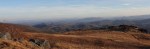
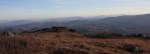
These two panoramic photos taken from a recent trip to Whitetop Mountain show the expansive vista to the southeast at the summit.
If you click on them in an updated browser, they should open in a much larger format that is pretty awesome viewed on 16:9 monitor. There is a slight overlap in the two photographs, but together they form almost a single, panoramic image.
Virginia into North Carolina Panorama
The Blue Ridge in North Carolina Panorama
As I state in the main article, the views at the top of Whitetop certainly justify the climb to the summit.
There is also a gravel road from the east side of Whitetop that goes to the summit of Whitetop. It is Route 89, and it connects to Route 600 near Elk Graden. Route 89 is usually open even in winter, although it is covered in snowpack and requires a 4 x 4.
In Washington County, Virginia, less than a score of miles from Abingdon, is one of the most impressive series of waterfalls in Virginia.
Abrams Falls
This October the owner of Abrams Falls, who is an acquaintance and client of mine, graciously took my son Karl and I for a viewing and photography shoot of the falls.
This is a special place worthy of protection and preservation. It’s almost hard to believe such a natural formation exists on private property, right in the most populous county in Southwest Virginia, unknown to most people who live here.
Front View of Abrams Falls
There is a series of waterfalls here, the major of which is a plunge-type waterfall of about 70′ that continues with a secondary cascade waterfall that drops over a series of ledges for another 15 or 20′. The main falls drop into a large, natural amphitheatre of sedimentary rock that forms a semicircle of 180°. Below the falls, Abrams Creek continues to flow through a 500′ deep, extremely steep, horseshoe-shaped gorge for over 1/2 mile.
Boy in Foreground Shows Scale of the Falls
The size of these falls can be appreciated in the photo above. Note the boy in the foreground on the right of the photo; he is almost 100′ from the base of the falls.
Abrams Falls create their own micro-environment. Mist and moisture at the base of the falls make for conditions that allow certain rare plants to grow.
Abrams Falls – The Main 70′ Plunge
Upper Falls
The falls are located on private property not currently open to the public. There is no road directly to the falls. To get to the falls, one must hike in for about a mile. There is not any developed trail to the falls. There are two semi-trails that property owners and trespassers have used. Numerous trespassers have died or been injured over the years trying (without permission of the landowner) to see the falls.
Abrams Creek has several additional noteworthy falls. On our hike, we passed the first, unnamed cataract below. The fall colors were either at their peak, or just slightly past their peak, and made for a great backdrop.
Abrams Falls - The First Cataract
There is another waterfall, I will call it the Upper Abrams Creek Falls, and it is impressive in its own right. It is about a 15-20′ cascade waterfall that spans about 40 feet across. It is at the Upper Falls that the mountains begin to close in to form the gorge.
Abrams Falls - The Upper FallsAbrams Falls - The Upper Falls - The Full Second Cascade
The Gorge
The mountainsides become quite steep downstream from the Upper Falls. Our hike left Abrams Creek at this point, and we began to climb up the mountainside in order to take a safer way to the main falls. This path also allowed us to better view the horseshoe-shaped gorge. The hiking here was strenuous.
The Upper Falls - The mountainside entering into the gorge
The photograph below shows the opposite side of the gorge. This gorge is so closed in that it is difficult to photograph in a way that conveys how steep and deep it is. It reminded me of a miniature version of the New River Gorge in West Virginia, or perhaps even more the Russell Fork Gorge. There are rock outcroppings and cliffs on both sides of the Abrams Creek Gorge. Abrams Creek flows about 500 vertical feet below the highest point of the trail.
Abrams Falls Gorge
We traveled to a point at the top of the mountain that allowed us to view the horseshoe shape of the gorge, and then we began our descent into the amphitheatre where the main falls are located. This descent was quite steep. As we descended, we could hear the ever-increasing sound of the falls crashing on the rocks below. In the photo below, the property owner leads the way down the path toward the falls.
Abrams Falls - Descending into the amphitheatre
The Amphitheatre
The amphitheatre is formed by 70-80′ cliffs that surround the falls. The photo below is from about 3/4 of the way down into the amphitheatre and shows the steep cliff face.
Abrams Falls Cliff
When there is high water, the force of the creek and the falls must be incredible. In the photo below, you can see a large tree that is up against the opposite canyon wall. This tree was about 35′ in length, and could not have been moved even if we had tried to do so.
There were several large, ordinarily immovable pieces of wood that looked like they had been thrown around down into the gorge. It reminded me of the way you might see random timber lodged against the walls of a Southwestern U.S. slot canyon from flash floods. I would surmise Abrams Creek is also susceptible to flash flooding.
Side Wall of the Amphitheatre
While the main plunge is the central scenic feature, the cascades at the base complement it and complete the falls. In the front-on photo of the falls below, you can see how the cascades spread out beneath the plunge.
Abrams Falls - The Main Lower Cascade
The falls are a true plunge-type falls. Viewed from the side, they look like a bridal veil. There is actually room to get behind the falls, but the rocks are extremely slick, and it would have been dangerous to approach any closer that we did.
Abrams Falls - Side View
The mist from the falls can be felt 50′ from the base of the falls. The roar of the falls at the base of the amphitheatre makes conversation difficult. The whole experience of being at these falls—a completely natural, pristine, and extraordinary place so close to Abingdon—was quite remarkable.
Abrams Falls - Misty Bottom of Plunge
NOTE: The photos here are published with permission of the landowner. Please enjoy these photos, and at this time appreciate this place through them.
These falls are not on public property. It is illegal to trespass on private property in Virginia. This trip and photo shoot was conducted at the invitation of the landowner. The general public is not invited to visit the premises at this time.
There have been fatal and other serious accidents involving illegal trespassers at Abrams Falls. Respect the landowner of this property, and do not attempt to visit the falls unless you have permission.
One of the gems of the Mount Rogers National Recreation Area is Fox Creek. Nestled between the south side of Iron Mountain and the north side of Mount Rogers, Fox Creek flows east through about 5 miles of National Forest before entering private property down the mountainside.
Fox Creek
Lower Fox Creek
The lower section of the creek that lies within the national forest flows through a miniature gorge. Large boulders and timbers create numerous beautiful pools of water. Fox Creek Falls, a fan-type cascading waterfall, is a much photographed feature. The photo below shows Fox Creek Falls from a side angle, a less traditional view. (Click on any of the photos in this article to enlarge them.)
Fox Creek Falls
The two trips we took to Fox Creek in October revealed remarkable foilage on the moss-covered boulders. Although past their peak vibrancy, the leaves created a tapestry of color that I needed to capture with the camera.
Fallen Timber and Boulders Create a Striking Foreground
The first day we arrived in the middle of the afternoon. The sunlight was too harsh for good photography, so we came back the next day in the later afternoon. The boulders in the creek are quite large; in the photo below, you can see my son Isaac playing on one of them.
One of the Larger PoolsAutumn Leaves Dress Up Huge Boulders
Upper Fox Creek
The upper part of Fox Creek is formed when Lewis Fork Branch joins the Fox Creek headwater. At this point, the creek becomes a full fledged, albeit small, trout stream. A modest, high elevation valley forms between Mount Rogers and Iron Mountain. The National Recreation Area has a large, split rail fence that runs along Virginia Route 603 for several miles.
Along this section of road is the trailhead for the Mount Rogers Trail, Grindstone Campground, a parking lot for the Appalachian Trail, the Fairwood Horse Camping Area, and the entrance to the unimproved road that goes up to the Scales area of Pine Mountain.
One Entrance to Upper Fox Creek
Fox Creek in this area is a small, swiftly moving creek with a gentle gradient remiscent of a Midwestern trout stream or an Eastern chalk stream as much as typical freestone stream. However, the flow of the creek is variable as it is dependent on runoff from Mount Rogers.
Stalking Wild Trout
The views up and down the valley are Western-like. In fact, much of the Mount Rogers area reminds many people, including me, of the West. It’s like a little slice of the West dropped into Southwest Virginia.
Evening Glow in Fox Creek MeadowFly Fishing for Wild Trout
The large meadows along upper Fox Creek provide many starting points for short hikes. There are also numerous places to begin longer hikes up Mount Rogers or Iron Mountain.
Thanksgiving is tomorrow. During this time we often reminisce and reflect on what’s happened in the past year and give thanks for the good things we have in our lives. Along the themes of reminiscence and reflection, here are some tranquil, reflective photos from a trip my son Karl and I took to Hidden Valley Lake one evening in this November.
Reflections on Hidden Valley Lake
We approached the eastern side of the lake just as a series of interesting cloud formations developed in the otherwise clear evening sky. The lake was very still—there was no wind—and the reflections looking back toward the sun were magnificent. (Click on any of these photos to enlarge them.)
Shoreline Reflections
The leaves had already mostly fallen, but as can be seen in the above photo, there were still oaks on the far side of the lake that clung to some of their dark auburn foliage.
Surrounded by Clouds
We were the only two people in the valley. There was absolute quiet except for the sound of the rushing water in the distance at the dam.
The air was crisp and had a unique, slightly sweet scent. I have since come to learn that Hidden Valley at one time may have been a high elevation bog. There are some unusual plants in the valley that give off the unique scent in the late fall. I have discussed with Virginia Game and Inland Fisheries that it may be Possum Haw aka Shawnee Haw or Nanny Berry, or it may even be the bark from some of the trees after the leaves have fallen and they are more exposed to the air and sun.
Karl and I went for a hike to explore upper Brumley Creek. The creek’s headwaters are formed from the lake’s drainage, high elevation springs, and smaller creeks in the valley.
Upon our return, most of the clouds had rolled away. In the stillness of evening, the lake made an almost perfect reflecting pool. Faint light and muted features caused the scene to look like an impressionist painting:
Reflecting back on this year, I’ve spent a lot of time in the outdoors with my family. That’s one thing, among many other things, for which I am thankful.